Mayhew, Mississippi
Encyclopedia

Unincorporated area
In law, an unincorporated area is a region of land that is not a part of any municipality.To "incorporate" in this context means to form a municipal corporation, a city, town, or village with its own government. An unincorporated community is usually not subject to or taxed by a municipal government...
in Lowndes County
Lowndes County, Mississippi
As of the census of 2000, there were 61,586 people, 22,849 households, and 16,405 families residing in the county. The population density was 123 people per square mile . There were 25,104 housing units at an average density of 50 per square mile...
in the U.S. state
U.S. state
A U.S. state is any one of the 50 federated states of the United States of America that share sovereignty with the federal government. Because of this shared sovereignty, an American is a citizen both of the federal entity and of his or her state of domicile. Four states use the official title of...
of Mississippi
Mississippi
Mississippi is a U.S. state located in the Southern United States. Jackson is the state capital and largest city. The name of the state derives from the Mississippi River, which flows along its western boundary, whose name comes from the Ojibwe word misi-ziibi...
.
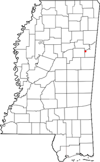
Mayhew is located at 33°29′05"N 88°38′04"W west of Columbus
Columbus, Mississippi
Columbus is a city in Lowndes County, Mississippi, United States that lies above the Tombigbee River. It is approximately northeast of Jackson, north of Meridian, south of Tupelo, northwest of Tuscaloosa, Alabama, and west of Birmingham, Alabama. The population was 25,944 at the 2000 census...
, north of Artesia
Artesia, Mississippi
Artesia is a town in Lowndes County, Mississippi, United States. The population was 498 at the 2000 census.-History:Artesia was originally Artesia Junction, a junction point on the Mobile and Ohio Railroad. During the railroad's construction in the 1850s, an offer was made to the towns of Columbus...
, east of Starkville
Starkville, Mississippi
-Demographics:As of the census of 2000, there were 21,869 people, 9,462 households, and 4,721 families residing in the city. The population density was 851.4 people per square mile . There were 10,191 housing units at an average density of 396.7 per square mile...
and south of West Point
West Point, Mississippi
West Point is a city in Clay County, Mississippi, United States. The population was 12,145 at the 2000 census. It is the county seat of Clay County and the principal city of the West Point Micropolitan Statistical Area, which is part of the larger Columbus-West Point Combined Statistical...
. According to the United States Geological Survey
United States Geological Survey
The United States Geological Survey is a scientific agency of the United States government. The scientists of the USGS study the landscape of the United States, its natural resources, and the natural hazards that threaten it. The organization has four major science disciplines, concerning biology,...
, a variant name is Mayhew Station. Mayhew Station was the original name given to this community when it was moved from its original site (near Muldrow, Mississippi) to alongside the tracks of the newly built Mobile and Ohio Railroad (later Gulf, Mobile & Ohio) in the very early 1850s. The original location of the town of Mayhew is now referred to as Old Mayhew, but only a cemetery exists there today. Mayhew held the distinction for most of the 20th Century as being home to Stover Apiaries, the world's largest Queen Bee apiary, which shipped queen bees to beekeepers worldwide.
Mayhew is also referred to as Mayhew Junction, or more commonly as "The Crossroads" by area residents, a reference to when US Highways 82 and 45 crossed as at-grade two-lane highways. Before the construction of the new US 82 and the expansion of US 45 to four lanes, the intersection of the original highways was a four way stop, because it was quite dangerous. Several bars and service stations lined the four sides of the original intersection, and were torn down when the new expressways were built over a period of several years between 1975 and 1995.
The East Mississippi Community College
East Mississippi Community College
East Mississippi Community College , also known as East Mississippi Junior College, is a community college system in Mississippi with its headquarters in the Thomas L. Davis, Jr...
Golden Triangle Campus is in Mayhew.

