Mendoza River
Encyclopedia

Provinces of Argentina
Argentina is subdivided into twenty-three provinces and one autonomous city...
of Mendoza
Mendoza Province
The Province of Mendoza is a province of Argentina, located in the western central part of the country in the Cuyo region. It borders to the north with San Juan, the south with La Pampa and Neuquén, the east with San Luis, and to the west with the republic of Chile; the international limit is...
, Argentina
Argentina
Argentina , officially the Argentine Republic , is the second largest country in South America by land area, after Brazil. It is constituted as a federation of 23 provinces and an autonomous city, Buenos Aires...
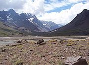
. It is formed in the Andes
Andes
The Andes is the world's longest continental mountain range. It is a continual range of highlands along the western coast of South America. This range is about long, about to wide , and of an average height of about .Along its length, the Andes is split into several ranges, which are separated...
range between the Aconcagua
Aconcagua
Aconcagua is the highest mountain in the Americas at . It is located in the Andes mountain range, in the Argentine province of Mendoza and it lies west by north of its capital, the city of Mendoza. The summit is also located about 5 kilometres from San Juan Province and 15 kilometres from the...
and the Tupungato
Tupungato
Tupungato, one of the highest mountains in South America, is a massive stratovolcano dating to Pleistocene times. It lies on the border between the Chilean Metropolitan Region and the , near a major international highway about 80 km east of Santiago, Chile. It is located about south of Monte...
, by the confluence of the Vacas, the Cuevas and the Tupungato River
Tupungato River
The Tupungato River is a river located in the western zone of the Mendoza Province called Uco Valley , flows in Luján de Cuyo and Tupungato departments, to the west of Argentina. It arises on the Del Plomo and Del Juncal glaciers in the north of the Tupungato Mountain and ends at the Mendoza River...
s, the last being its major tributary.

Above mean sea level
The term above mean sea level refers to the elevation or altitude of any object, relative to the average sea level datum. AMSL is used extensively in radio by engineers to determine the coverage area a station will be able to reach...
, and it is U-shaped, of glacial
Glacier
A glacier is a large persistent body of ice that forms where the accumulation of snow exceeds its ablation over many years, often centuries. At least 0.1 km² in area and 50 m thick, but often much larger, a glacier slowly deforms and flows due to stresses induced by its weight...
origin. The river reaches Uspallata
Uspallata
Uspallata is a village, and an administrative district, in Argentina in a scenic location on the road which crosses the Andes between Mendoza and Santiago in Chile. It is located west of Mendoza and was once served by the now disused Transandine Railway which passed through the town on its way...
, then crosses the Precordillera through the Potrerillos Valley
Potrerillos, Mendoza
Potrerillos is an area of the Luján de Cuyo Department of the province of Mendoza, Argentina. It includes a number of small settlements along Provincial Routes 82 and 89, National Route 7, and the rivers Blanco and Mendoza...
, flows along the Cacheuta Canyon and reaches the plain. It forms an arc and turns northeast, finally emptying into the Bañados de Guanacache, which join the San Juan River
San Juan River (Argentina)
The San Juan River is, together with the Jáchal, the most important river of the Argentine province of San Juan. Both join the Desaguadero/Colorado system that end at the Atlantic Ocean....
, part of the system of the Desaguadero River
Desaguadero River
The Desaguadero River is the general name of a river in western Argentina that receives a number of different names on its path of 1,515 kilometres, with its most important section named Desaguadero proper.-Spring:...
.
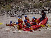
The river has a mean flow of 50 m³/s, and supplies water for the main oasis in the otherwise arid province. Its course through Potrerillos, at about 1,350 m AMSL, features rapid
Rapid
A rapid is a section of a river where the river bed has a relatively steep gradient causing an increase in water velocity and turbulence. A rapid is a hydrological feature between a run and a cascade. A rapid is characterised by the river becoming shallower and having some rocks exposed above the...
s, which are employed for rafting
Rafting
Rafting or white water rafting is a challenging recreational outdoor activity using an inflatable raft to navigate a river or other bodies of water. This is usually done on white water or different degrees of rough water, in order to thrill and excite the raft passengers. The development of this...
(level III–IV in the International Scale of River Difficulty
International Scale of River Difficulty
The International Scale of River Difficulty is a standardized scale used to rate the safety of a stretch of river, or a single rapid. The grade reflects the technical difficulty and skill level required associated with the section of river...
during the summer). In Potrerillos the river is also dam
Dam
A dam is a barrier that impounds water or underground streams. Dams generally serve the primary purpose of retaining water, while other structures such as floodgates or levees are used to manage or prevent water flow into specific land regions. Hydropower and pumped-storage hydroelectricity are...
med, forming a reservoir, which feeds a hydroelectric
Hydroelectricity
Hydroelectricity is the term referring to electricity generated by hydropower; the production of electrical power through the use of the gravitational force of falling or flowing water. It is the most widely used form of renewable energy...
power station
Power station
A power station is an industrial facility for the generation of electric energy....
.
The Cacheuta Spa
Cacheuta Spa
The Cacheuta Hot Springs are natural hot springs at Cacheuta on the Mendoza River in the foothills of the Andes....
and the Potrerillos Dam are tourist destinations along the river.
Mendoza River irrigates the Maipú and Lujan vineyards, located in Mendoza piedmont, at 30° south latitude. This region hosts 17% of the Mendoza vineyards
Mendoza wine
The Mendoza Province is one of Argentina's most important wine regions, accounting for nearly two-thirds of the country's entire wine production. Located in the eastern foothills of the Andes, in the shadow of Mount Aconcagua, vineyards are planted at the some of the highest altitudes in the world...
, and 360 wineries.

