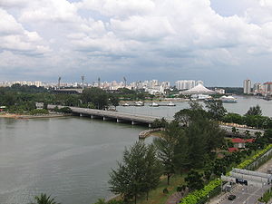
Merdeka Bridge
Encyclopedia

Pedestrian
A pedestrian is a person traveling on foot, whether walking or running. In some communities, those traveling using roller skates or skateboards are also considered to be pedestrians. In modern times, the term mostly refers to someone walking on a road or footpath, but this was not the case...
bridge
Bridge
A bridge is a structure built to span physical obstacles such as a body of water, valley, or road, for the purpose of providing passage over the obstacle...
located in Kallang
Kallang
Kallang is an urban planning area and a subdivision located in the southeastern part of Singapore.It is probably best known for being the location of the Singapore Indoor Stadium & the old National Stadium, as well as the new Singapore Sports Hub...
in the south-eastern part of Singapore
Singapore
Singapore , officially the Republic of Singapore, is a Southeast Asian city-state off the southern tip of the Malay Peninsula, north of the equator. An island country made up of 63 islands, it is separated from Malaysia by the Straits of Johor to its north and from Indonesia's Riau Islands by the...
. It spans over the river mouths of the Kallang River
Kallang River
The Kallang River flows for 10 kilometres from the Lower Peirce Reservoir to the coast at Nicoll Highway, making it the longest river in Singapore...
and Rochor River
Rochor River
Rochor River is a canalised river in Kallang of the Central Region in Singapore. The river is about 0.8 km in length....
, which empty into the Kallang Basin. Designed by the Public Works Department the bridge was officially opened on August 17, 1956.
Etymology
The name MerdekaMerdeka
Merdeka is a word in the Indonesian and Malay language meaning Independent or freedom. It is derived from the Sanskrit Maharddhika meaning "rich, prosperous and powerful". In the Malay archipelago, this term had acquired the meaning of a freed slave...
means "independence
Independence
Independence is a condition of a nation, country, or state in which its residents and population, or some portion thereof, exercise self-government, and usually sovereignty, over its territory....
" in Malay
Malay language
Malay is a major language of the Austronesian family. It is the official language of Malaysia , Indonesia , Brunei and Singapore...
, and the bridge marked Singapore's freedom and independence when it was given internal self-government from the British
British Empire
The British Empire comprised the dominions, colonies, protectorates, mandates and other territories ruled or administered by the United Kingdom. It originated with the overseas colonies and trading posts established by England in the late 16th and early 17th centuries. At its height, it was the...
in 1955.
History
When the Merdeka Bridge was built, it formed the vital link between the city centreDowntown Core
The Downtown Core is a 266-hectare urban planning area in the south of the city-state of Singapore. The Downtown Core surrounds the mouth of the Singapore River and southeastern portion of its watershed, and is part of the Central Area, Singapore's central business district...
and the rapidly growing east coast
East Region, Singapore
The East Region of Singapore is one of the five regions in the city-state. It includes six urban planning areas. As its name implies, it is the easternmost region of Singapore.The land area is about 11,000 hectares.-Urban planning areas in East Region:...
via the Nicoll Highway
Nicoll Highway
Nicoll Highway is a major arterial road in Singapore which links Kallang to the city. En route, it passes through the areas of Kallang, Kampong Glam and Marina Centre....
. Its role is now taken over by the Benjamin Sheares Bridge
Benjamin Sheares Bridge
Opened in 1981, the Benjamin Sheares Bridge is the longest bridge in Singapore, spanning 1.8 km, and the tallest, at 20 m. It is named after Dr Benjamin Henry Sheares, the 2nd president of the Republic. The bridge is part of the East Coast Parkway...
on the East Coast Parkway
East Coast Parkway
The East Coast Parkway is an expressway that runs along the southeastern coast of Singapore. The expressway is approximately in length, and connects Singapore Changi Airport in the east to the Benjamin Sheares Bridge in the south of the main island before it links with the Ayer Rajah Expressway...
.
Visually, the bridge's only attributes were the two stone lions guarding its entrances and known as the Merdeka lions. These sculptures by Rudolfo Nolli
Rudolfo Nolli
Cavaliere Rudolfo Nolli — was a sculptor and architect from Lombardy, who during the first half of the 20th century worked mainly at the gulf of Siam....
have since been removed, first to Airport Road, and are currently placed at the SAFTI Military Institute
SAFTI Military Institute
The SAFTI Military Institute is a tri-service military training institution for officers of all ranks of the Singapore Armed Forces . Located within an 88 hectare campus in Jurong West, it was officially opened by the then-prime minister Goh Chok Tong on 25 August 1995...
in Jurong
Jurong
Jurong is the largest town in the western part of Singapore, consisting of 11 residential precincts, 14 industrial districts, 1 military zone and 1 Waterfront district. It resembles Woodlands, the largest town in the northern part of Singapore, which is smaller in size, has smaller industrial area...
. Then they were moved to HQ 2PDF in Clementi Camp.

