
Metropolitan Borough of Poplar
Encyclopedia
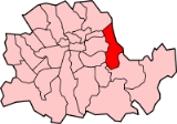
Poplar was a local government district in the metropolitan area of London
, England. It was formed as a district of the Metropolis in 1855 and became a metropolitan borough
in the County of London
in 1900. It comprised the civil parishes of Bow
, Bromley
and Poplar
until 1907, when it also became a civil parish. In 1965 the parish and borough were abolished, with their former area becoming part of the newly formed London Borough of Tower Hamlets
.
, Stepney
, and Bethnal Green
to the west and north, and the county of Essex
to the east. To the south, the River Thames
formed borders with the metropolitan boroughs of Bermondsey
, Deptford
and Greenwich
.
It included the districts of (from north to south):
and the Poor Law Union
were engaged in a dispute with the London County Council
and central government over poor law
rates - it wished to pay out of work people more than usually permitted; and to get wealthier West End
boroughs to contribute to its expenses. Several councillors were imprisoned briefly in 1921 in relation to this. See Poplar Rates Rebellion
.
In 1951 Poplar was chosen as the site of the Festival of Britain's
'Exhibition of Live Architecture'. The East End of London had been heavily bombed during the war and its reconstruction was showcased at the new Lansbury Estate. New building materials and planning concepts were demonstrated. The first example of 'live architecture' on the exhibition trail was the Trinity Congregational Church and Hall
, just across from the main reception area with their Town Planning and Building Research Pavilions on East India Dock Road. The trail continued with the Lansbury Estate
and Chrisp Street Market
.
Civil Parishes and Poplar Board of Works 1801-1899
Metropolitan Borough 1900-1961
, using instead a seal originally designed for the Poplar District Board of Works, its predecessor, created by the Metropolis Management Act 1855
. The seal depicted the emblems of the three parish vestries
merged into the board.
The top shield was the seal of Poplar Vestry, and showed the 'Hibbert
Gate' of the old West India Docks
, with a sailing ship on top of the shield. A similar representation of the gate and ship formed the head of the vestry's civic mace, which was used by the board of works and borough council until 1965.
The shield on the left was the seal of Bow Vestry , and showed a bridge between two bows. This represented the bow-shaped bridge over the River Lea.
The shield on the right was the seal of Bromley St Leonard Vestry, and depicts the saint dressed as a bishop.
London
London is the capital city of :England and the :United Kingdom, the largest metropolitan area in the United Kingdom, and the largest urban zone in the European Union by most measures. Located on the River Thames, London has been a major settlement for two millennia, its history going back to its...
, England. It was formed as a district of the Metropolis in 1855 and became a metropolitan borough
Metropolitan boroughs of the County of London
The term metropolitan borough was used from 1900 to 1965, for the subdivisions of the County of London created by the London Government Act 1899....
in the County of London
County of London
The County of London was a county of England from 1889 to 1965, corresponding to the area known today as Inner London. It was created as part of the general introduction of elected county government in England, by way of the Local Government Act 1888. The Act created an administrative County of...
in 1900. It comprised the civil parishes of Bow
Bow, London
Bow is an area of London, England, United Kingdom in the London Borough of Tower Hamlets. It is a built-up, mostly residential district located east of Charing Cross, and is a part of the East End.-Bridges at Bowe:...
, Bromley
Bromley-by-Bow
Bromley-by-Bow, historically and officially Bromley, is a place in the London Borough of Tower Hamlets. It is an inner-city district situated east north-east of Charing Cross.-Toponymy:...
and Poplar
Poplar, London
Poplar is a historic, mainly residential area of the East End of London in the London Borough of Tower Hamlets. It is about east of Charing Cross. Historically a hamlet in the parish of Stepney, Middlesex, in 1817 Poplar became a civil parish. In 1855 the Poplar District of the Metropolis was...
until 1907, when it also became a civil parish. In 1965 the parish and borough were abolished, with their former area becoming part of the newly formed London Borough of Tower Hamlets
London Borough of Tower Hamlets
The London Borough of Tower Hamlets is a London borough to the east of the City of London and north of the River Thames. It is in the eastern part of London and covers much of the traditional East End. It also includes much of the redeveloped Docklands region of London, including West India Docks...
.
Boundaries
The borough bordered the metropolitan boroughs of HackneyMetropolitan Borough of Hackney
The Metropolitan Borough of Hackney was a Metropolitan borough of the County of London from 1900 to 1965. Its area became part of the London Borough of Hackney.-Formation and boundaries:...
, Stepney
Metropolitan Borough of Stepney
The Metropolitan Borough of Stepney was a Metropolitan borough in the County of London created in 1900. In 1965 it became part of the London Borough of Tower Hamlets.-Boundaries:...
, and Bethnal Green
Metropolitan Borough of Bethnal Green
Bethnal Green was a civil parish and a metropolitan borough in the East End of London, England. It was formed as a civil parish in 1743 from the Bethnal Green hamlet in Stepney ancient parish. The vestry became an electing authority to the Metropolitan Board of Works in 1855 and in 1889 it became...
to the west and north, and the county of Essex
Essex
Essex is a ceremonial and non-metropolitan county in the East region of England, and one of the home counties. It is located to the northeast of Greater London. It borders with Cambridgeshire and Suffolk to the north, Hertfordshire to the west, Kent to the South and London to the south west...
to the east. To the south, the River Thames
River Thames
The River Thames flows through southern England. It is the longest river entirely in England and the second longest in the United Kingdom. While it is best known because its lower reaches flow through central London, the river flows alongside several other towns and cities, including Oxford,...
formed borders with the metropolitan boroughs of Bermondsey
Metropolitan Borough of Bermondsey
The Metropolitan Borough of Bermondsey was a Metropolitan borough in the County of London, created in 1900 by the London Government Act 1899. It was abolished and its area became part of the London Borough of Southwark in 1965.-History:...
, Deptford
Metropolitan Borough of Deptford
The Metropolitan Borough of Deptford was a Metropolitan borough in the County of London between 1900 and 1965, when it became part of the London Borough of Lewisham along with the Metropolitan Borough of Lewisham....
and Greenwich
Metropolitan Borough of Greenwich
The Metropolitan Borough of Greenwich was a Metropolitan borough in the County of London between 1900 and 1965. Within the area of the borough were the Royal Naval College , the Royal Observatory and Greenwich Park. It bordered the boroughs of Woolwich, Deptford, Lewisham...
.
It included the districts of (from north to south):
- BowBow, LondonBow is an area of London, England, United Kingdom in the London Borough of Tower Hamlets. It is a built-up, mostly residential district located east of Charing Cross, and is a part of the East End.-Bridges at Bowe:...
- Bromley St LeonardBromley-by-BowBromley-by-Bow, historically and officially Bromley, is a place in the London Borough of Tower Hamlets. It is an inner-city district situated east north-east of Charing Cross.-Toponymy:...
- PoplarPoplar, LondonPoplar is a historic, mainly residential area of the East End of London in the London Borough of Tower Hamlets. It is about east of Charing Cross. Historically a hamlet in the parish of Stepney, Middlesex, in 1817 Poplar became a civil parish. In 1855 the Poplar District of the Metropolis was...
- BlackwallBlackwall, LondonBlackwall is an area of the East End of London, situated in the London Borough of Tower Hamlets on the north bank of the River Thames.The district around Blackwall Stairs was known as Blackwall by at least the 14th century. This presumably derives from the colour of the river wall, constructed in...
- Isle of DogsIsle of DogsThe Isle of Dogs is a former island in the East End of London that is bounded on three sides by one of the largest meanders in the River Thames.-Etymology:...
History
In 1921 the Borough Council, under George LansburyGeorge Lansbury
George Lansbury was a British politician, socialist, Christian pacifist and newspaper editor. He was a Member of Parliament from 1910 to 1912 and from 1922 to 1940, and leader of the Labour Party from 1932 to 1935....
and the Poor Law Union
Poor Law Union
A Poor Law Union was a unit used for local government in the United Kingdom from the 19th century. The administration of the Poor Law was the responsibility of parishes, which varied wildly in their size, populations, financial resources, rateable values and requirements...
were engaged in a dispute with the London County Council
London County Council
London County Council was the principal local government body for the County of London, throughout its 1889–1965 existence, and the first London-wide general municipal authority to be directly elected. It covered the area today known as Inner London and was replaced by the Greater London Council...
and central government over poor law
Poor Law
The English Poor Laws were a system of poor relief which existed in England and Wales that developed out of late-medieval and Tudor-era laws before being codified in 1587–98...
rates - it wished to pay out of work people more than usually permitted; and to get wealthier West End
West End of London
The West End of London is an area of central London, containing many of the city's major tourist attractions, shops, businesses, government buildings, and entertainment . Use of the term began in the early 19th century to describe fashionable areas to the west of Charing Cross...
boroughs to contribute to its expenses. Several councillors were imprisoned briefly in 1921 in relation to this. See Poplar Rates Rebellion
Poplar Rates Rebellion
The Poplar Rates Rebellion, or Poplar Rates Revolt was a tax protest that took place in Poplar, London, England, in 1921. It was led by George Lansbury, the previous year's Labour Mayor of Poplar, with the support of the Poplar Borough Council, most of whom were industrial workers. The protest...
.
In 1951 Poplar was chosen as the site of the Festival of Britain's
Festival of Britain
The Festival of Britain was a national exhibition in Britain in the summer of 1951. It was organised by the government to give Britons a feeling of recovery in the aftermath of war and to promote good quality design in the rebuilding of British towns and cities. The Festival's centrepiece was in...
'Exhibition of Live Architecture'. The East End of London had been heavily bombed during the war and its reconstruction was showcased at the new Lansbury Estate. New building materials and planning concepts were demonstrated. The first example of 'live architecture' on the exhibition trail was the Trinity Congregational Church and Hall
Trinity Independent Chapel
Now a Methodist chapel, the original Trinity Independent Chapel was designed in 1840-41 by William Hosking FSA, at Poplar, in the London Borough of Tower Hamlets, and built by John Jay....
, just across from the main reception area with their Town Planning and Building Research Pavilions on East India Dock Road. The trail continued with the Lansbury Estate
Lansbury Estate
The Lansbury Estate is a public housing estate in the Poplar area of the London Borough of Tower Hamlets named after George Lansbury, a Poplar councillor and Labour party MP.It is one of the largest such estates in London...
and Chrisp Street Market
Chrisp Street Market
Chrisp Street Market was designed by Frederick Gibberd, and built as part of the Festival of Britain in 1951. It is located in Poplar in the London Borough of Tower Hamlets, and forms part of the eastern edge of the Lansbury Estate....
.
Population and area
Poplar covered an area of 2328 acres (9.4 km²). The population as given in the census from 1801 to 1961 was:Civil Parishes and Poplar Board of Works 1801-1899
| Year | 1801 | 1811 | 1821 | 1831 | 1841 | 1851 | 1861 | 1871 | 1881 | 1891 |
|---|---|---|---|---|---|---|---|---|---|---|
| Population | 8,278 | 13,548 | 18,932 | 25,066 | 31,122 | 47,162 | 79,196 | 116,376 | 156,510 | 166,748 |
Metropolitan Borough 1900-1961
| Year | 1901 | 1911 | 1921 | 1931 | 1941 | 1951 | 1961 |
|---|---|---|---|---|---|---|---|
| Population | 168,822 | 162,442 | 162,578 | 155,089 | 73,579 | 66,604 |
Borough seal
The borough had no coat of armsCoat of arms
A coat of arms is a unique heraldic design on a shield or escutcheon or on a surcoat or tabard used to cover and protect armour and to identify the wearer. Thus the term is often stated as "coat-armour", because it was anciently displayed on the front of a coat of cloth...
, using instead a seal originally designed for the Poplar District Board of Works, its predecessor, created by the Metropolis Management Act 1855
Metropolis Management Act 1855
The Metropolis Management Act 1855 was an Act of the Parliament of the United Kingdom that created the Metropolitan Board of Works, a London-wide body to co-ordinate the construction of the city's infrastructure. The Act also created a second tier of local government consisting of parish vestries...
. The seal depicted the emblems of the three parish vestries
Vestry
A vestry is a room in or attached to a church or synagogue in which the vestments, vessels, records, etc., are kept , and in which the clergy and choir robe or don their vestments for divine service....
merged into the board.
The top shield was the seal of Poplar Vestry, and showed the 'Hibbert
George Hibbert
George Hibbert was an eminent English merchant, politician, slave- and ship-owner, amateur botanist and book collector. With Robert Milligan, he was also one of the principals of the West India Dock Company which instigated the construction of the West India Docks on London's Isle of Dogs in 1800...
Gate' of the old West India Docks
West India Docks
The West India Docks are a series of three docks on the Isle of Dogs in London, the first of which opened in 1802. The docks closed to commercial traffic in 1980 and the Canary Wharf development was built on the site.-History:...
, with a sailing ship on top of the shield. A similar representation of the gate and ship formed the head of the vestry's civic mace, which was used by the board of works and borough council until 1965.
The shield on the left was the seal of Bow Vestry , and showed a bridge between two bows. This represented the bow-shaped bridge over the River Lea.
The shield on the right was the seal of Bromley St Leonard Vestry, and depicts the saint dressed as a bishop.