

Miller Atlas
Encyclopedia
Portugal
Portugal , officially the Portuguese Republic is a country situated in southwestern Europe on the Iberian Peninsula. Portugal is the westernmost country of Europe, and is bordered by the Atlantic Ocean to the West and South and by Spain to the North and East. The Atlantic archipelagos of the...
richly illustrated atlas
Atlas
An atlas is a collection of maps; it is typically a map of Earth or a region of Earth, but there are atlases of the other planets in the Solar System. Atlases have traditionally been bound into book form, but today many atlases are in multimedia formats...
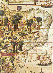
dated from 1519, including a dozen charts. It is joint work of cartographers Lopo Homem
Lopo Homem
Lopo Homem was a Portuguese cartographer and cosmographer.- Biography :In 1517 King Manuel I of Portugal handed Lopo Homem a charter entitling him the privilege of certifying and amending all compass needles in vessels. This charter was revalidated in 1524 by King John III of Portugal...
, Pedro Reinel
Pedro Reinel
Pedro Reinel was a Portuguese cartographer of the 16th century, author of one of the oldest signed Portuguese nautical chart . That is a portolan type of chart, covering western Europe and part of Africa, and already reflecting the explorations made by Diogo Cão in 1482-1485. With his son Jorge...
and Jorge Reinel
Jorge Reinel
Jorge Reinel born Lisbon renown Portuguese cartographer and instructor in cartography, son of the well-known cartographer Pedro Reinel. In 1519 in Seville he participated in the maps designed for the trip of his countryman Ferdinand Magellan, and his depiction of the Maluku Islands served as a...
illustrated by miniaturist António de Holanda.
The regions represented are the North Atlantic Ocean, Northern Europe, the Azores Archipelago, Madagascar, Indian Ocean, Indonesia, China Sea, the Moluccas, Brazil and the Mediterranean Sea. It was acquired in 1897 by the National Library of France to the librarian Bénigne Emmanuel Clement Miller, hence the name Atlas Miller.
It stands out for details of the map Terra Brasilis less than twenty years after the landing of Pedro Alvares Cabral. And it is thought to have been an offer from King Manuel I of Portugal
Manuel I of Portugal
Manuel I , the Fortunate , 14th king of Portugal and the Algarves was the son of Infante Ferdinand, Duke of Viseu, , by his wife, Infanta Beatrice of Portugal...
to Francis I of France
Francis I of France
Francis I was King of France from 1515 until his death. During his reign, huge cultural changes took place in France and he has been called France's original Renaissance monarch...
. The charts included and its authoring raised great controversy among scholars. Particularly a world map enclosed to the Pacific Ocean, which has been interpreted as an attempt to dissuade the circumnavigation that Magellan then prepared in Seville, in the court of Charles I of Spain.
Its title page bears a later inscription with the arms of Catherine de Medici with the text "Hec est universi orbis ad hanc usqz diem cogniti / tabula quam ego Lupus homo Cosmographus / in clarissima Ulisipone civitate Anno domini nostri / Millessimo quigentessimo decimo nono jussu / Emanuelis incliti lusitanie Regis collatis pluribs / aliis tam vetustorum qz recentiorum tabulis mag / na industria et dilligenti labore depinxi."