

Mitchell Point Tunnel
Encyclopedia
Tunnel
A tunnel is an underground passageway, completely enclosed except for openings for egress, commonly at each end.A tunnel may be for foot or vehicular road traffic, for rail traffic, or for a canal. Some tunnels are aqueducts to supply water for consumption or for hydroelectric stations or are sewers...
located towards the eastern end of the Historic Columbia River Highway in Oregon
Oregon
Oregon is a state in the Pacific Northwest region of the United States. It is located on the Pacific coast, with Washington to the north, California to the south, Nevada on the southeast and Idaho to the east. The Columbia and Snake rivers delineate much of Oregon's northern and eastern...
, United States
United States
The United States of America is a federal constitutional republic comprising fifty states and a federal district...
. It existed from 1915 to 1966.
History
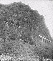
The Mitchell Point Tunnel was blasted through solid rock high up on the bluff of Mitchell Point
Mitchell Point (Oregon)
Mitchell Point is a cape in the Columbia River Gorge in Hood River County, Oregon, United States.Little is known about the man named Mitchell for whom the point was named. He was believed to be a trapper who lived and died in the area...
, 95 feet (29 m) above the Columbia River
Columbia River
The Columbia River is the largest river in the Pacific Northwest region of North America. The river rises in the Rocky Mountains of British Columbia, Canada, flows northwest and then south into the U.S. state of Washington, then turns west to form most of the border between Washington and the state...
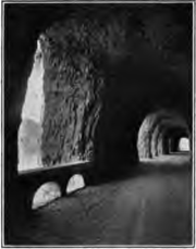
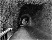
. Its five windows, carved through basalt
Basalt
Basalt is a common extrusive volcanic rock. It is usually grey to black and fine-grained due to rapid cooling of lava at the surface of a planet. It may be porphyritic containing larger crystals in a fine matrix, or vesicular, or frothy scoria. Unweathered basalt is black or grey...
ic rock, afforded a scenic view of the Columbia River Gorge
Columbia River Gorge
The Columbia River Gorge is a canyon of the Columbia River in the Pacific Northwest of the United States. Up to deep, the canyon stretches for over as the river winds westward through the Cascade Range forming the boundary between the State of Washington to the north and Oregon to the south...
. Motorists could pause and enjoy watching steamboats plying the Columbia River far below, or gaze up at rugged, snow capped volcanoes Mount Adams
Mount Adams (Washington)
Mount Adams is a potentially activestratovolcano in the Cascade Range and the second-highest mountain in the U.S. state of Washington.Adams is a member of the Cascade Volcanic Arc, and is one of the arc's largest volcanoes,...
and Mount St. Helens
Mount St. Helens
Mount St. Helens is an active stratovolcano located in Skamania County, Washington, in the Pacific Northwest region of the United States. It is south of Seattle, Washington and northeast of Portland, Oregon. Mount St. Helens takes its English name from the British diplomat Lord St Helens, a...
.
The Mitchell Point Tunnel was a prominent feature of the Columbia River Highway, now known as the Historic Columbia River Highway. This famous roadway stretched 125 miles (200 km) along the Oregon side of the Columbia River between Portland
Portland, Oregon
Portland is a city located in the Pacific Northwest, near the confluence of the Willamette and Columbia rivers in the U.S. state of Oregon. As of the 2010 Census, it had a population of 583,776, making it the 29th most populous city in the United States...
and The Dalles
The Dalles, Oregon
The Dalles is the largest city and county seat of Wasco County, Oregon, United States. The name of the city comes from the French word dalle The Dalles is the largest city and county seat of Wasco County, Oregon, United States. The name of the city comes from the French word dalle The Dalles is...
. The road is recognized as an engineering marvel and as America's first scenic highway.
Although the tunnel's two-way, 18-foot (5.5 m) roadbed was considered adequate by 1915 standards, vehicles became larger and wider during the 1920s. Truck traffic also became more common on the highway. Eventually, a signal was installed at each entry of the tunnel, alternately allowing east and west, one-way traffic to avert collisions.
By the 1930s, the tunnel was considered inadequate for modern traffic. A wider, river-level route (now designated U.S. Route 30) was built at the base of Mitchell Point around 1954. The five famous windows were bricked up, the tunnel filled with rock, and the viaduct
Viaduct
A viaduct is a bridge composed of several small spans. The term viaduct is derived from the Latin via for road and ducere to lead something. However, the Ancient Romans did not use that term per se; it is a modern derivation from an analogy with aqueduct. Like the Roman aqueducts, many early...
s leading to the tunnel were blocked.
The once-celebrated tunnel remained abandoned, but intact, until 1966 when the Mitchell Point Tunnel was destroyed during the widening of Interstate 84.
There are now plans to re-create the tunnel by the Oregon Department of Transportation
Oregon Department of Transportation
The Oregon Department of Transportation is a department of the state government of the U.S. state of Oregon responsible for systems of transportation. It was first established in 1969. It had been preceded by the Oregon State Highway Department which, along with the Oregon State Highway...
as part of its ongoing restoration of the Historic Columbia River Highway.
External links
- Vintage Postcards of Mitchell Point Tunnel
- Historic American Engineering Record report on Mitchell Point Tunnel
- Article about the tunnel's engineer from the University of Washington alumni magazine