
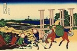
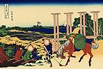
Mito Kaido
Encyclopedia
was an old kaidō
in Japan
and a subroute to the Edo Five Routes
. It was built to connect Edo
with Mito
in modern-day Ibaraki Prefecture
. Travelers from Edo called it Mito Kaidō, but travelers from Mito called it Edo Kaidō. The kaidō's path is traced by the modern National Route 6
.
Tokyo
Chiba Prefecture
Kaido
were ancient roads in Japan dating from the Edo period. Major examples include the Edo Five Routes, all of which started at Edo...
in Japan
Japan
Japan is an island nation in East Asia. Located in the Pacific Ocean, it lies to the east of the Sea of Japan, China, North Korea, South Korea and Russia, stretching from the Sea of Okhotsk in the north to the East China Sea and Taiwan in the south...
and a subroute to the Edo Five Routes
Edo Five Routes
The were the five major roads that started at Edo during the Edo period, the most important of which was the Tōkaidō, which linked Edo and Kyoto...
. It was built to connect Edo
Edo
, also romanized as Yedo or Yeddo, is the former name of the Japanese capital Tokyo, and was the seat of power for the Tokugawa shogunate which ruled Japan from 1603 to 1868...
with Mito
Mito, Ibaraki
is the capital of Ibaraki Prefecture, Japan and has a central location, moderately offset towards the coast in that prefecture. As of 2005, the city has an estimated population of 263,748 and a total area is 217.45 km², giving a population density of 1,212.91 persons per km²...
in modern-day Ibaraki Prefecture
Ibaraki Prefecture
is a prefecture of Japan, located in the Kantō region on the main island of Honshu. The capital is Mito.-History:Ibaraki Prefecture was previously known as Hitachi Province...
. Travelers from Edo called it Mito Kaidō, but travelers from Mito called it Edo Kaidō. The kaidō's path is traced by the modern National Route 6
Route 6 (Japan)
National Route 6 is a Japanese highway which goes from Tokyo via Mito and Hitachi in Ibaraki Prefecture towards Sendai. The route traces the old Mito Kaidō from Tokyo to Mito...
.
TokyoTokyo, ; officially , is one of the 47 prefectures of Japan. Tokyo is the capital of Japan, the center of the Greater Tokyo Area, and the largest metropolitan area of Japan. It is the seat of the Japanese government and the Imperial Palace, and the home of the Japanese Imperial Family...
- 1. Senju-shuku (千住宿) (AdachiAdachi, Tokyois one of the Special wards of Tokyo, Japan. It is located north of the heart of Tokyo. The ward consists of two separate areas: a small strip of land between the Sumida River and Arakawa River and a larger area north of the Arakawa River...
) (also part of the Nikkō KaidōNikko KaidoThe was one of the five routes of the Edo period and it was built to connect Edo with the Nikkō Tōshō-gū, which is located in the present-day city of Nikkō, Tochigi Prefecture, Japan. It was established in 1617 by Tokugawa Ieyasu, in order for him to have a smoother route to the shrine...
) - 2. Ara-shuku (新宿) (KatsushikaKatsushika, Tokyois one of the special wards of Tokyo, Japan. It lies in the northeast of the ward area. The ward calls itself Katsushika City in English.As of 2008, the ward has an estimated population of 429,289 and a density of 12,600 people per km²...
)
Chiba PrefectureChiba Prefectureis a prefecture of Japan located in the Kantō region and the Greater Tokyo Area. Its capital is Chiba City.- History :Chiba Prefecture was established on June 15, 1873 with the merger of Kisarazu Prefecture and Inba Prefecture...
- 3. Matsudo-shuku (松戸宿) (MatsudoMatsudo, Chibais a city located in northern Chiba Prefecture, Japan. As of February 2011, the city had an estimated population of 484,578 and a population density of 7900 persons per km²...
) - 4. Kogane-shuku (小金宿) (Matsudo)
- 5. Abiko-shuku (我孫子宿) (AbikoAbiko, Chibais a city located in northern Chiba Prefecture, Japan. As of February 2011, the town had an estimated population of 134,154 and a population density of 3110 persons per km²...
)
Ibaraki Prefecture
- 6. Toride-shuku (取手宿) (TorideToride, Ibarakiis a city located in Ibaraki, Japan.As of March 1, 2008 , the city has an estimated population of 109,926 and the density of 1,570 persons per km². The total area is 69.96 km²....
) - 7. Fujishiro-shuku (藤代宿) (Toride)
- 8. Wakashiba-shuku (若柴宿) (RyūgasakiRyugasaki, Ibarakiis a city located in Ibaraki, Japan.-Overview:As of April 1, 2011, the city has an estimated population of 79,269, with household number being 30,470, and a population density of . The total area is ....
) - 9. Ushiku-shuku (牛久宿) (UshikuUshiku, Ibarakiis a city located in Ibaraki, Japan.As of 2010, the city has an estimated population of 81,532 and a density of 1,380 persons per km². The total area is 58.88 km²....
) - 10. Arakawaoki-shuku (荒川沖宿) (TsuchiuraTsuchiura, Ibarakiis a city located in Ibaraki prefecture, in Japan. It is situated along the western shores of Lake Kasumigaura, the second largest lake in Japan. Tokyo city lies about 60 km to the south, and Tsukuba science city borders Tsuchiura to the west.-Demographics:...
) - 11. Nakamura-shuku (中村宿) (Tsuchiura)
- 12. Tsuchiura-shuku (土浦宿) (Tsuchiura)
- 13. Nakanuki-shuku (中貫宿) (Tsuchiura)
- 14. Inayoshi-shuku (稲吉宿) (KasumigauraKasumigaura, Ibarakiis a city located in Ibaraki, Japan. Kasumigaura was formerly a town in Niihari District and became a city on March 28, 2005 after merging with the neighboring town of Chiyoda, also from Niihari District. The city takes its name from the nearby lake, Lake Kasumigaura...
) - 15. Fuchū-shuku (府中宿) (IshiokaIshioka, Ibarakiis a city located in Ibaraki, Japan.As of 2003, the city has an estimated population of 52,755 and the density of 885.15 persons per km². The total area is 59.60 km².The city was founded on February 11, 1954....
) - 16. Takehara-shuku (竹原宿) (OmitamaOmitama, Ibarakiis a city located in Ibaraki, Japan. The city was formed on March 27, 2006 from the merger of the towns of Ogawa and Minori, both from Higashiibaraki District, and the village of Tamari, from Niihari District...
) - 17. Katakura-shuku (片倉宿) (Omitama)
- 18. Obata-shuku (小幡宿) (IbarakiIbaraki, Ibarakiis a town located in Higashiibaraki District, Ibaraki, Japan.The town was set to merge with Mito, Ibaraki on December 8, 2007, but following the election of a new mayor in April 2007, these plans were abandoned....
, Higashiibaraki DistrictHigashiibaraki District, Ibarakiis a district located in Ibaraki, Japan.As of 2003, the district has an estimated population of 122,478 and a density of 284 persons per km². The total area is 431.44 km².-Towns and villages:*Ibaraki*Ōarai*Shirosato-Mergers:...
) - 19. Nagaoka-shuku (長岡宿) (Ibaraki, Higashiibaraki District)
- 20. Mito-shuku (水戸宿) (MitoMito, Ibarakiis the capital of Ibaraki Prefecture, Japan and has a central location, moderately offset towards the coast in that prefecture. As of 2005, the city has an estimated population of 263,748 and a total area is 217.45 km², giving a population density of 1,212.91 persons per km²...
)