

Morro Redondo
Encyclopedia
{| border="1" cellpadding="2" cellspacing="0" style="float:right; empty-cells:show; margin-left:1em; margin-bottom:0,5em; background:#FFDEAD;"
|-
! colspan="2" | Map
|---- bgcolor="#FFFFFF"
! colspan="2" align="center" |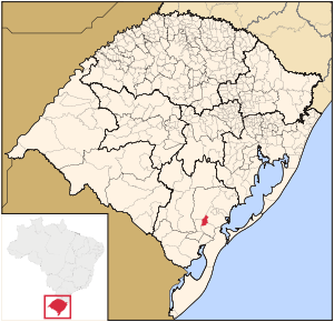 |-
|-
! colspan="2" | Statistics
|---- bgcolor="#FFFFFF"
| State: || Rio Grande do Sul
|---- bgcolor="#FFFFFF"
| Meso-region: || Southeastern Rio Grande do Sul
(Sudoeste Rio-Grandense)
|---- bgcolor="#FFFFFF"
| Micro-Region: || Pelotas
|---- bgcolor="#FFFFFF"
| Founded: || May 12, 1988
|---- bgcolor="#FFFFFF" valign="top"
| Location
: || 31.5875 or 31° 35' 18" S lat.
52.6298 or 52° 37/ 55" W long.
|---- bgcolor="#FFFFFF"
| Area
: || 247.14 km²
|---- bgcolor="#FFFFFF"
| Population
(2005):
- Total
- Change
- Density ||
5,961
-
24.12/km²
|---- bgcolor="#FFFFFF"
| Elevation
: || 245 m
|---- bgcolor="#FFFFFF"
| Postal code: || -
{| border="1" cellpadding="2" cellspacing="0" style="float:right; empty-cells:show; margin-left:1em; margin-bottom:0,5em; background:#FFDEAD;"
|-
! colspan="2" | Map
|---- bgcolor="#FFFFFF"
! colspan="2" align="center" |
|-
! colspan="2" | Statistics
|---- bgcolor="#FFFFFF"
| State: || Rio Grande do Sul
|---- bgcolor="#FFFFFF"
| Meso-region: || Southeastern Rio Grande do Sul
(Sudoeste Rio-Grandense)
|---- bgcolor="#FFFFFF"
| Micro-Region: || Pelotas
|---- bgcolor="#FFFFFF"
| Founded: || May 12, 1988
|---- bgcolor="#FFFFFF" valign="top"
| Location
: || 31.5875 or 31° 35' 18" S lat.
52.6298 or 52° 37/ 55" W long.
|---- bgcolor="#FFFFFF"
| Area
: || 247.14 km²
|---- bgcolor="#FFFFFF"
| Population
(2005):
- Total
- Change
- Density ||
5,961
-
24.12/km²
|---- bgcolor="#FFFFFF"
| Elevation
: || 245 m
|---- bgcolor="#FFFFFF"
| Postal code: || -
|---- bgcolor="#FFFFFF"
| Website: || www.morroredondo.rs.gov.br
|}
Morro Redondo (English: Rounded Hill) is a Brazil
ian city in the southeastwern part of the state of Rio Grande do Sul
. Its population in 2001 was 5,961. It is located 35 km (21.75 mi) from Pelotas
.
 Much of the population have Portuguese origin mainly from the Azores
and Germans
mainly from Pomerania
, the remainder were from Italy
.
). Small groves of cultivated trees (Babylon willow, eucalyptus
, pine
, cypress
, acacia
, poplar
and platanus
) and native trees (Cockspur coral tree and araucaria angustifolia
) are also found.
 The climate is subtropical or temperate, with pleasant summers, cool winters and frequent frost
s (with an average of 20 per year). The hottest month is January with an average temperature of 21.7°C (71.06°F), and the coldest month is July with an average temperature of 11.7°C (53.06°F). The wettest month is February, with 150 mm (5.9 in) of precipitation. The average annual temperature in the municipality is 16.7°C (62.06°F). The average annual precipitation is 1,400 mm (55.11 in).
|-
! colspan="2" | Map
|---- bgcolor="#FFFFFF"
! colspan="2" align="center" |
! colspan="2" | Statistics
|---- bgcolor="#FFFFFF"
| State: || Rio Grande do Sul
Rio Grande do Sul
Rio Grande do Sul is the southernmost state in Brazil, and the state with the fifth highest Human Development Index in the country. In this state is located the southernmost city in the country, Chuí, on the border with Uruguay. In the region of Bento Gonçalves and Caxias do Sul, the largest wine...
|---- bgcolor="#FFFFFF"
| Meso-region: || Southeastern Rio Grande do Sul
(Sudoeste Rio-Grandense)
|---- bgcolor="#FFFFFF"
| Micro-Region: || Pelotas
Pelotas (micro-region)
The Pelotas Microregion is a micro-region in the southeastern part of the state of Rio Grande do Sul, Brazil. The area is 10,306.601 km².- Municipalities:*Arroio do Padre*Canguçu*Capão do Leão*Cerrito*Cristal...
|---- bgcolor="#FFFFFF"
| Founded: || May 12, 1988
|---- bgcolor="#FFFFFF" valign="top"
| Location
Location (geography)
The terms location and place in geography are used to identify a point or an area on the Earth's surface or elsewhere. The term 'location' generally implies a higher degree of can certainty than "place" which often has an ambiguous boundary relying more on human/social attributes of place identity...
: || 31.5875 or 31° 35' 18" S lat.
52.6298 or 52° 37/ 55" W long.
|---- bgcolor="#FFFFFF"
| Area
Area
Area is a quantity that expresses the extent of a two-dimensional surface or shape in the plane. Area can be understood as the amount of material with a given thickness that would be necessary to fashion a model of the shape, or the amount of paint necessary to cover the surface with a single coat...
: || 247.14 km²
|---- bgcolor="#FFFFFF"
| Population
Population
A population is all the organisms that both belong to the same group or species and live in the same geographical area. The area that is used to define a sexual population is such that inter-breeding is possible between any pair within the area and more probable than cross-breeding with individuals...
(2005):
- Total
- Change
- Density ||
5,961
-
24.12/km²
|---- bgcolor="#FFFFFF"
| Elevation
Elevation
The elevation of a geographic location is its height above a fixed reference point, most commonly a reference geoid, a mathematical model of the Earth's sea level as an equipotential gravitational surface ....
: || 245 m
|---- bgcolor="#FFFFFF"
| Postal code: || -
{| border="1" cellpadding="2" cellspacing="0" style="float:right; empty-cells:show; margin-left:1em; margin-bottom:0,5em; background:#FFDEAD;"
|-
! colspan="2" | Map
|---- bgcolor="#FFFFFF"
! colspan="2" align="center" |
! colspan="2" | Statistics
|---- bgcolor="#FFFFFF"
| State: || Rio Grande do Sul
Rio Grande do Sul
Rio Grande do Sul is the southernmost state in Brazil, and the state with the fifth highest Human Development Index in the country. In this state is located the southernmost city in the country, Chuí, on the border with Uruguay. In the region of Bento Gonçalves and Caxias do Sul, the largest wine...
|---- bgcolor="#FFFFFF"
| Meso-region: || Southeastern Rio Grande do Sul
(Sudoeste Rio-Grandense)
|---- bgcolor="#FFFFFF"
| Micro-Region: || Pelotas
Pelotas (micro-region)
The Pelotas Microregion is a micro-region in the southeastern part of the state of Rio Grande do Sul, Brazil. The area is 10,306.601 km².- Municipalities:*Arroio do Padre*Canguçu*Capão do Leão*Cerrito*Cristal...
|---- bgcolor="#FFFFFF"
| Founded: || May 12, 1988
|---- bgcolor="#FFFFFF" valign="top"
| Location
Location (geography)
The terms location and place in geography are used to identify a point or an area on the Earth's surface or elsewhere. The term 'location' generally implies a higher degree of can certainty than "place" which often has an ambiguous boundary relying more on human/social attributes of place identity...
: || 31.5875 or 31° 35' 18" S lat.
52.6298 or 52° 37/ 55" W long.
|---- bgcolor="#FFFFFF"
| Area
Area
Area is a quantity that expresses the extent of a two-dimensional surface or shape in the plane. Area can be understood as the amount of material with a given thickness that would be necessary to fashion a model of the shape, or the amount of paint necessary to cover the surface with a single coat...
: || 247.14 km²
|---- bgcolor="#FFFFFF"
| Population
Population
A population is all the organisms that both belong to the same group or species and live in the same geographical area. The area that is used to define a sexual population is such that inter-breeding is possible between any pair within the area and more probable than cross-breeding with individuals...
(2005):
- Total
- Change
- Density ||
5,961
-
24.12/km²
|---- bgcolor="#FFFFFF"
| Elevation
Elevation
The elevation of a geographic location is its height above a fixed reference point, most commonly a reference geoid, a mathematical model of the Earth's sea level as an equipotential gravitational surface ....
: || 245 m
|---- bgcolor="#FFFFFF"
| Postal code: || -
|---- bgcolor="#FFFFFF"
| Website: || www.morroredondo.rs.gov.br
|}
Morro Redondo (English: Rounded Hill) is a Brazil
Brazil
Brazil , officially the Federative Republic of Brazil , is the largest country in South America. It is the world's fifth largest country, both by geographical area and by population with over 192 million people...
ian city in the southeastwern part of the state of Rio Grande do Sul
Rio Grande do Sul
Rio Grande do Sul is the southernmost state in Brazil, and the state with the fifth highest Human Development Index in the country. In this state is located the southernmost city in the country, Chuí, on the border with Uruguay. In the region of Bento Gonçalves and Caxias do Sul, the largest wine...
. Its population in 2001 was 5,961. It is located 35 km (21.75 mi) from Pelotas
Pelotas
Pelotas is a Brazilian city and municipality , the third most populous in the southern state of Rio Grande do Sul. Pelotas is located 270 km from Porto Alegre, the capital city of the state, and 130 km from the Uruguayan border...
.
Demographics
Azores
The Archipelago of the Azores is composed of nine volcanic islands situated in the middle of the North Atlantic Ocean, and is located about west from Lisbon and about east from the east coast of North America. The islands, and their economic exclusion zone, form the Autonomous Region of the...
and Germans
Germany
Germany , officially the Federal Republic of Germany , is a federal parliamentary republic in Europe. The country consists of 16 states while the capital and largest city is Berlin. Germany covers an area of 357,021 km2 and has a largely temperate seasonal climate...
mainly from Pomerania
Pomerania
Pomerania is a historical region on the south shore of the Baltic Sea. Divided between Germany and Poland, it stretches roughly from the Recknitz River near Stralsund in the West, via the Oder River delta near Szczecin, to the mouth of the Vistula River near Gdańsk in the East...
, the remainder were from Italy
Italy
Italy , officially the Italian Republic languages]] under the European Charter for Regional or Minority Languages. In each of these, Italy's official name is as follows:;;;;;;;;), is a unitary parliamentary republic in South-Central Europe. To the north it borders France, Switzerland, Austria and...
.
Climate and vegetation
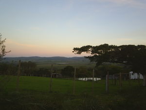
Most of the area of the municipality are above 200 m (656.16 ft) of elevation. A vegetation of this area is mainly composed of fields with low and herbaceous vegetation (pampaPampa
The Pampas are the fertile South American lowlands, covering more than , that include the Argentine provinces of Buenos Aires, La Pampa, Santa Fe, Entre Ríos and Córdoba, most of Uruguay, and the southernmost Brazilian State, Rio Grande do Sul...
). Small groves of cultivated trees (Babylon willow, eucalyptus
Eucalyptus
Eucalyptus is a diverse genus of flowering trees in the myrtle family, Myrtaceae. Members of the genus dominate the tree flora of Australia...
, pine
Pine
Pines are trees in the genus Pinus ,in the family Pinaceae. They make up the monotypic subfamily Pinoideae. There are about 115 species of pine, although different authorities accept between 105 and 125 species.-Etymology:...
, cypress
Cypress
Cypress is the name applied to many plants in the cypress family Cupressaceae, which is a conifer of northern temperate regions. Most cypress species are trees, while a few are shrubs...
, acacia
Acacia
Acacia is a genus of shrubs and trees belonging to the subfamily Mimosoideae of the family Fabaceae, first described in Africa by the Swedish botanist Carl Linnaeus in 1773. Many non-Australian species tend to be thorny, whereas the majority of Australian acacias are not...
, poplar
Poplar
Populus is a genus of 25–35 species of deciduous flowering plants in the family Salicaceae, native to most of the Northern Hemisphere. English names variously applied to different species include poplar , aspen, and cottonwood....
and platanus
Platanus
Platanus is a small genus of trees native to the Northern Hemisphere. They are the sole living members of the family Platanaceae....
) and native trees (Cockspur coral tree and araucaria angustifolia
Araucaria angustifolia
Araucaria angustifolia, the Paraná pine or Brazilian pine , is a species in the conifer genus Araucaria. Covering an original area of 233000 km², it is native to southern Brazil Araucaria angustifolia, the Paraná pine or Brazilian pine , is a species in the conifer genus Araucaria. Covering an...
) are also found.
Frost
Frost is the solid deposition of water vapor from saturated air. It is formed when solid surfaces are cooled to below the dew point of the adjacent air as well as below the freezing point of water. Frost crystals' size differ depending on time and water vapour available. Frost is also usually...
s (with an average of 20 per year). The hottest month is January with an average temperature of 21.7°C (71.06°F), and the coldest month is July with an average temperature of 11.7°C (53.06°F). The wettest month is February, with 150 mm (5.9 in) of precipitation. The average annual temperature in the municipality is 16.7°C (62.06°F). The average annual precipitation is 1,400 mm (55.11 in).
External links
- Official website of the prefecture
- http://www.citybrazil.com.br/rs/morroredondo/
- Map and Aerial photos:
- Coordinates: 31°35′18"S 52°37′55"W
- Street maps: Street map from Mapquest, MapPoint or Google
- Satellite images and Aerial photos: Google