Motorways and roads in Cyprus
Encyclopedia

Cyprus
Cyprus , officially the Republic of Cyprus , is a Eurasian island country, member of the European Union, in the Eastern Mediterranean, east of Greece, south of Turkey, west of Syria and north of Egypt. It is the third largest island in the Mediterranean Sea.The earliest known human activity on the...
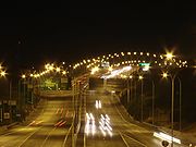
has developed one of the most modern road networks in Europe
Europe
Europe is, by convention, one of the world's seven continents. Comprising the westernmost peninsula of Eurasia, Europe is generally 'divided' from Asia to its east by the watershed divides of the Ural and Caucasus Mountains, the Ural River, the Caspian and Black Seas, and the waterways connecting...
. According to 2002 statistics, the road network in the free areas of Cyprus consists of about 7,206 km of paved and 4,387 km of unpaved roads. Although the first motorway in Cyprus, A1
A1 motorway (Cyprus)
The A1 motorway marked the beginning of an ambitious government project to link all the main cities on the island with modern 4 lane highways. It is 73 km long and is free of any at-grade intersections...
, was completed as recently as October 1985, the country already has the most motorway km per capita (38.6km /100,000 inhabitants) amongst all European Union
European Union
The European Union is an economic and political union of 27 independent member states which are located primarily in Europe. The EU traces its origins from the European Coal and Steel Community and the European Economic Community , formed by six countries in 1958...
members.
There are no toll paying roads in Cyprus to date.
Maintenance
The Public Works Department of the Ministry of Communications and Works is responsible for the maintenance, improvement and construction of motorways, the majority of rural and interurban road network and the main urban roads. The Municipalities are responsible for the secondary and local urban roads; the District Administration Authorities are responsible for the paved and unpaved district (tertiary) roads and village roads. The Forestry Department is responsible for most unpaved roads in forest areas, this is in order to accommodate the administration and protection of forests.The Turkish invasion of 1974 radically changed the program of road development and created new priorities in order to cover the augmented needs in the government controlled areas, where 80% of the Cyprus population and the greatest portion of development had concentrated.
Under these circumstances New Road Development Schemes were promoted, which were partially financed by foreign Financing Organizations. Under these development projects new 4 lane motorways were constructed and more are on their way as follows:
Cyprus Motorways List


| Motorway logo | Connecting Cities | Status | Special Features |
|---|---|---|---|
 |
A1 Nicosia - Limassol A1 motorway (Cyprus) The A1 motorway marked the beginning of an ambitious government project to link all the main cities on the island with modern 4 lane highways. It is 73 km long and is free of any at-grade intersections... |
Completed | 1st Motorway in Cyprus, 5,200m Emergency runway |
 |
A2 Nicosia - Larnaca A2 motorway (Cyprus) thumb|leftThe A2 motorway branches off the A1 at Pera Chorio-Nisou and connects to the A3. It is locally referred to as the Nicosia - Larnaca motorway . It is also called "the tube" due to its mostly straight with a very limited number of exits.... |
Completed | 1st Modern Motorway in Cyprus, 1st Motorway Interchange Interchange (road) In the field of road transport, an interchange is a road junction that typically uses grade separation, and one or more ramps, to permit traffic on at least one highway to pass through the junction without directly crossing any other traffic stream. It differs from a standard intersection, at which... in Cyprus |
 |
A3 Larnaca Airport - Ayia Napa A3 motorway (Cyprus) The A3 motorway is a modern motorway linking Larnaca International Airport, the largest airport in Cyprus, and Ayia Napa, a very popular clubbing paradise. It is 55 km long. The road was built in five phases and took about 10 years to be completed... |
Completed | First Beltway in Cyprus |
 |
A5 Larnaca - Limassol A5 motorway (Cyprus) The A5 links the A1 motorway with the A3 near Larnaca. It serves as the main route linking the cities of Limassol and Larnaca . It runs parallel to the older B5 Main Road.... |
Completed | 5,000m Emergency runway |
 |
A6 Limassol - Paphos A6 motorway (Cyprus) The A6 highway marked the ending of an ambitious government project to link all the main cities on the island with modern four-lane, high-speed highways. It is 66 km long and is free of any at-grade intersections... |
Completed | 950m tunnel Tunnel A tunnel is an underground passageway, completely enclosed except for openings for egress, commonly at each end.A tunnel may be for foot or vehicular road traffic, for rail traffic, or for a canal. Some tunnels are aqueducts to supply water for consumption or for hydroelectric stations or are sewers... , 110m tall bridge Bridge A bridge is a structure built to span physical obstacles such as a body of water, valley, or road, for the purpose of providing passage over the obstacle... , one of the 300 largest in the world. |
 |
A7 Paphos - Polis A7 motorway (Cyprus) The A7 is a planned Motorway to link the city of Paphos with Polis, a small town in the north west of the island.- Overview :This motorway is one of the oldest demands of locals, due to number of accidents happened on the B7 road , and due to the constant heavy traffic on it... |
Final Plans | 3 tunnels |
 |
A8 Limassol - Saittas | Preliminary Designs | N/A |
 |
A9 Nicosia - Astromeritis A9 motorway (Cyprus) A9 is a highway under construction which is planned to connect Nicosia, the capital of Cyprus, with the Troödos Mountains. Currently this highway is completed until the small village of Dhenia. The project has stopped until the safety of planers will be established... |
Partly under construction | 1st Urban Motorway in Cyprus |
 |
Nicosia 3rd Ring road A22 motorway (Cyprus) The A22 is a future Motorway planned to bypass the capital of Cyprus, Nicosia. This road is in the process of final plans.... |
Final Plans | 2 km long underground within Lakatamia |
The highway network is continuously developed. The first section of the A9 Nicosia - Astomeritis
A9 motorway (Cyprus)
A9 is a highway under construction which is planned to connect Nicosia, the capital of Cyprus, with the Troödos Mountains. Currently this highway is completed until the small village of Dhenia. The project has stopped until the safety of planers will be established...
Motorway between Kokkinotrimithia
Kokkinotrimithia
Kokkinotrimithia is a town located west of Nicosia, Cyprus, close to the Green Line. It has an exit along the A9 motorway. In 2001 it had 3096 inhabitants and a prediction of 3101 for 2009....
and Akaki
Akaki, Cyprus
Akaki is a village in the Nicosia District of Cyprus....
has been completed, whereas the rest is under construction. Also the upgrading of the Limassol Junctions is completed.
The following are under design:


- Upgrading of the existing A1 Nicosia - LimassolA1 motorway (Cyprus)The A1 motorway marked the beginning of an ambitious government project to link all the main cities on the island with modern 4 lane highways. It is 73 km long and is free of any at-grade intersections...
Motorway to a 6 lane road between the StrovolosStrovolosStrovolos is a municipality of Nicosia. With a population of near 70,000, it is the second biggest municipality of Cyprus, after Limassol, and the biggest municipality of Nicosia...
Junction and Alampra Interchange. Road works already started.
- Limassol PortLimassol Port-Limassol New Port:Geographical Location: .Although a title held by Famagusta Port for centuries, Limassol Port has now become the principal seaport in Cyprus. This was largely a direct result of the Turkish invasion of Cyprus in 1974 leaving the port of Famagusta within occupied territory and...
connecting road. Construction began in June 2010.
- A7 Paphos - PolisA7 motorway (Cyprus)The A7 is a planned Motorway to link the city of Paphos with Polis, a small town in the north west of the island.- Overview :This motorway is one of the oldest demands of locals, due to number of accidents happened on the B7 road , and due to the constant heavy traffic on it...
Motorway is promoted through the D.B.F.O. method (Design, Build, Finance, Operate).
Preliminary and feasibility studies are conducted for the:
- Nicosia 3rd Ring road
- A8 Limassol - Saittas Motorway
- AstromeritisAstromeritisAstromeritis is a large village in the Morphou Department of the Nicosia District of Cyprus. It is located from the capital Nicosia...
- EvrychouEvrychouEvrychou is a village in Cyprus. It is located in the Nicosia District and the agricultural centre of the "Solea" region located about 50 km south-west of Nicosia and 30 km from mount Troodos.-Geography and climate:...
Motorway
- NicosiaNicosiaNicosia from , known locally as Lefkosia , is the capital and largest city in Cyprus, as well as its main business center. Nicosia is the only divided capital in the world, with the southern and the northern portions divided by a Green Line...
- Klirou Motorway
Road Network Categories and Numbering
Roads and Motorways in Cyprus can be classified into 5 main categories:- Motorways, 2 lanes per direction, free of any at-grade intersectionAt-grade intersectionAn at-grade intersection is a junction at which two or more transport axes cross at the same level .-Traffic management:With areas of high or fast traffic, an at-grade intersection normally requires a traffic control device such as a stop sign, traffic light or railway signal to manage conflicting...
s. They are the most important road network on the island, and the letter "A" is used on their official numbering system. Motorways usually run parallel to the same-number "B class" intercity roads that they replaced and sometimes these roads are even transformed to Motorways (e.g. A3 MotorwayA3 motorway (Cyprus)The A3 motorway is a modern motorway linking Larnaca International Airport, the largest airport in Cyprus, and Ayia Napa, a very popular clubbing paradise. It is 55 km long. The road was built in five phases and took about 10 years to be completed...
and B3 road). While there is no formal announcement about the numbering of new motorways under construction and under planning, it's anticipated that they will have the same number as their current main road. So Limassol - Saittas Motorway will be coded A8 because A is the letter of Motorways and 8 because it will "replace" B8 roadB8 road (Cyprus)The B8 is a main road of Cyprus. It connects the city of Limassol and the Troödos mountainous region. Although it's a very well maintained road, many accidents have occurred on it especially on a big bend near the village of Moniatis locally referred as the "turn of death"...
.
- Main Roads, Intercity roads, mostly one lane per direction, except sometimes in residential areas up to two lanes. B is the letter used in their official numbering system, with a number up to two digits long. Most of them have been replaced with their same-number Motorway (e.g. Traffic from NicosiaNicosiaNicosia from , known locally as Lefkosia , is the capital and largest city in Cyprus, as well as its main business center. Nicosia is the only divided capital in the world, with the southern and the northern portions divided by a Green Line...
to LimassolLimassolLimassol is the second-largest city in Cyprus, with a population of 228,000 . It is the largest city in geographical size, and the biggest municipality on the island. The city is located on Akrotiri Bay, on the island's southern coast and it is the capital of Limassol District.Limassol is the...
now uses the A1 MotorwayA1 motorway (Cyprus)The A1 motorway marked the beginning of an ambitious government project to link all the main cities on the island with modern 4 lane highways. It is 73 km long and is free of any at-grade intersections...
while in the past B1 road was the main connection between these cities)."B type" roads can be also main avenues within the city limits.
- Roads, secondary road network, mostly connecting rural areas. One lane per direction, always paved. They use the letter "E" in their formal numbering system and they are 3 digits long. First digit is the serial number of the main road that the secondary road begins from (or the secondary road, that begins at another secondary road which begins at a main road etc.) and the last two digits is the serial number of the road. Smaller digits where the main road begins, larger ones near main road's ending.
- Local roads, when coded during the 80's one lane and often dirt roads, today almost completely paved, and waiting for letter re - evaluation. They use "F" in the official coding system, and they are counted in the same way as "E"s are. There is no "E" with the same number as an "F".
- Unclassified roads. They can be "B" and "E" type. The case here is that these roads were constructed after the road network was numbered, so they will remain without a serial number and road signs will remain with gaps until the next road numbering evaluation.
Road safety
Cyprus currently holds a worse than average road safety record in the European UnionEuropean Union
The European Union is an economic and political union of 27 independent member states which are located primarily in Europe. The EU traces its origins from the European Coal and Steel Community and the European Economic Community , formed by six countries in 1958...
Official figures:
| 1991 | 1992 | 1993 | 1994 | 1995 | 1996 | 1997 | 1998 | 1999 | 2000 | 2001 | 2002 | 2003 | 2004 | 2005 | 2006 | 2007 | 2008 | 2009 | |
|---|---|---|---|---|---|---|---|---|---|---|---|---|---|---|---|---|---|---|---|
| Accidents | 3,172 | 3,052 | 3,021 | 2,080 | |||||||||||||||
| Injuries | 4,232 | 4,490 | 3,916 | 3,712 | 3,586 | 3,531 | 3,176 | 3,523 | 3,411 | ||||||||||
| Fatalities | 103 | 132 | 115 | 133 | 118 | 128 | 115 | 111 | 113 | 111 | 98 | 94 | 97 | 117 | 98 | 84 | 89 | 82 | |
| Fatalities/Million | 150 | 189 | 161 | 184 | 162 | 174 | 155 | 149 | 150 | 147 | 129 | 124 | 128 | 154 |

