Mount Inderbitzen
Encyclopedia

Mountain
Image:Himalaya_annotated.jpg|thumb|right|The Himalayan mountain range with Mount Everestrect 58 14 160 49 Chomo Lonzorect 200 28 335 52 Makalurect 378 24 566 45 Mount Everestrect 188 581 920 656 Tibetan Plateaurect 250 406 340 427 Rong River...
(3,000 m) rising to over 2,600 m, located 12 mi south-southeast of Mount Craddock
Mount Craddock
Mount Craddock is a large, bold mountain forming the south extremity of Craddock Massif in Sentinel Range, the highest mountain in Antarctica. It is linked by Karnare Col to Mount Strybing in the southern Sentinel Range...
and 1.5 mi south of Mount Milton
Mount Milton
Mount Milton is a mountain located 11 nautical miles south-southeast of Mount Craddock and 1.5 nautical miles southeast of Mount Southwick, in the south part of the Sentinel Range, Ellsworth Mountains in Antarctica...
in the southern part of the Sentinel Range
Sentinel Range
The Sentinel Range is a major mountain range situated northward of Minnesota Glacier and forming the northern half of the Ellsworth Mountains in Antarctica. The range trends NNW-SSE for about and is 24 to 48 km wide...
, Ellsworth Mountains
Ellsworth Mountains
The Ellsworth Mountains are the highest mountain ranges in Antarctica, forming a long and wide chain of mountains in a north to south configuration on the western margin of the Ronne Ice Shelf. They are bisected by Minnesota Glacier to form the northern Sentinel Range and the southern Heritage...
in Antarctica. It surmounts Wessbecher Glacier
Wessbecher Glacier
Wessbecher Glacier is a glacier about 7 nautical miles long, draining south between Wilson and Marze Peaks at the south end of the Sentinel Range, Ellsworth Mountains. First mapped by United States Geological Survey from surveys and U.S. Navy air photos, 1957-59. Named by Advisory Committee...
to the southeast and Sirma Glacier
Sirma Glacier
Sirma Glacier is the 7 km long and 4 km wide glacier on the west side of southern Sentinel Range in Ellsworth Mountains, Antarctica, situated south of Bolgrad Glacier, and flowing west-southwestwards from Mount Southwick, Mount Milton and Mount Inderbitzen to join Nimitz Glacier.The glacier is...
to the northwest.
First mapped by USGS from surveys and USN aerial photographs, 1957-59. Named by US-ACAN in 1994 after Anton L. Inderbitzen, Associate Chief Scientist, Division of Polar Programs, NSF
NSF
-Politics:* National Service Framework, any of a series of British government policies on medical care* National Socialist Front, a Swedish Nazi party* NS-Frauenschaft, the women's wing of the former German Nazi party...
, 1983-86; Head, Antarctic Staff, NSF, 1986-91; Deputy Assistant Director for Research, USGS, from 1991. At NSF, Inderbitzen was responsible for the coordination and planning of all scientific activities within the USAP
United States Antarctic Program
United States Antarctic Program is an organization of the United States government which has presence in the continent of Antarctica. It co-ordinates research and the operational support for research in the region...
, and for the formulation and enforcement of U.S. environmental regulations in Antarctica.
Maps
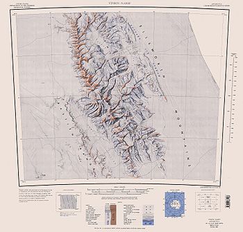
- Vinson Massif. Scale 1:250 000 topographic map. Reston, Virginia: US Geological Survey, 1988.

