Multilevel streets in Chicago
Encyclopedia

Chicago River
The Chicago River is a system of rivers and canals with a combined length of that runs through the city of the same name, including its center . Though not especially long, the river is notable for being the reason why Chicago became an important location, as the link between the Great Lakes and...
. The most famous and longest of these is Wacker Drive
Wacker Drive
Wacker Drive is a major street in Chicago, Illinois, United States, running along the south side of the main branch and the east side of the south branch of the Chicago River...
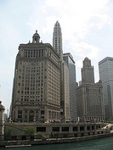
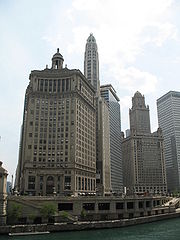
, which replaced the South Water Street Market upon its 1926 completion. The resulting bi-level street has an upper-level riverfront boulevard, a lower-level roadway for commercial and through traffic, and a recreational walkway at water level.
History
This configuration was due to geography and trafficTraffic
Traffic on roads may consist of pedestrians, ridden or herded animals, vehicles, streetcars and other conveyances, either singly or together, while using the public way for purposes of travel...
patterns in the Loop
Chicago Loop
The Loop or Chicago Loop is one of 77 officially designated Chicago community areas located in the City of Chicago, Illinois. It is the historic commercial center of downtown Chicago...
. Unlike most parts of the rest of the city near the river, most downtown streets crossed the river. All of these crossings are done by bascule bridge
Bascule bridge
A bascule bridge is a moveable bridge with a counterweight that continuously balances the span, or "leaf," throughout the entire upward swing in providing clearance for boat traffic....
s and each bridge required height clearances
Loading gauge
A loading gauge defines the maximum height and width for railway vehicles and their loads to ensure safe passage through bridges, tunnels and other structures...
at the approaches to and over the river. Further necessitating clearances were many existing railroad tracks
Rail tracks
The track on a railway or railroad, also known as the permanent way, is the structure consisting of the rails, fasteners, sleepers and ballast , plus the underlying subgrade...
that were along the river (as in the west bank of the south branch) or tracks that ended at the river (for example the tracks ending at Randolph Street
Randolph Street (Chicago)
Randolph Street is a street in Chicago. It runs east-west through the Chicago Loop, carrying westbound traffic west from Michigan Avenue across the Chicago River on the Randolph Street Bridge, interchanging with the Kennedy Expressway , and continuing west. It serves as the northern boundary of...
). Thus along the river at points of many closely spaced crossings, a clearance zone was created. Many double-decked or triple-decked streets came into being as a result of falling within this clearance zone.
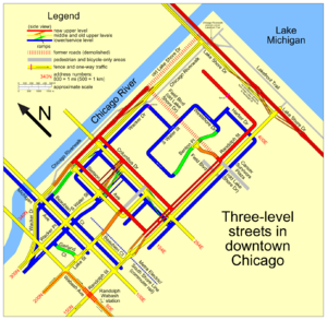
This also created an anomaly not only in the layout and uses of streets, but also planning of buildings. Generally, the upper levels of the multi-level streets usually serve local traffic. The primary entrances of buildings are usually located on this level. The lower levels generally serve through-traffic and trucks serving businesses along the roads. This level houses the receiving/shipping entrances to the buildings on these streets. Noticeable is the absence of such loading docks at street level.
The first raising occurred from 1855 to 1858, when streets and buildings were raised
Raising of Chicago
During the 1850s and 1860s engineers carried out a piecemeal raising of the level of central Chicago. Streets, sidewalks and buildings were either built up or else physically raised up on jacks...
between four and seven feet above their former elevation, just a few feet above lake
Lake Michigan
Lake Michigan is one of the five Great Lakes of North America and the only one located entirely within the United States. It is the second largest of the Great Lakes by volume and the third largest by surface area, after Lake Superior and Lake Huron...
level, where they were constantly muddy. The higher elevation allowed for sewer
Sanitary sewer
A sanitary sewer is a separate underground carriage system specifically for transporting sewage from houses and commercial buildings to treatment or disposal. Sanitary sewers serving industrial areas also carry industrial wastewater...
s and proper drainage
Drainage
Drainage is the natural or artificial removal of surface and sub-surface water from an area. Many agricultural soils need drainage to improve production or to manage water supplies.-Early history:...
. However, this did not produce any two-level streets; the first of those was Michigan Avenue
Michigan Avenue (Chicago)
Michigan Avenue is a major north-south street in Chicago which runs at 100 east south of the Chicago River and at 132 East north of the river from 12628 south to 950 north in the Chicago street address system...
in the late 1910s. When the Illinois Center
Illinois Center
Illinois Center is a mixed-use urban development in downtown Chicago, Illinois, USA, lying east of Michigan Avenue. It is notable in that the streets running through it have three levels. Elsewhere in Chicago, some streets have two levels, with the lower level for through traffic and service...
development was built on the east side of downtown, a new upper level was built, making most streets in that area three levels.
After about 1890, special interest groups, including recreational bicyclists, farmers delivering harvested crops to market, and motorists, began to mount support for concrete paving to replace the previously common dirt road
Dirt road
Dirt road is a common term for an unpaved road made from the native material of the land surface through which it passes, known to highway engineers as subgrade material. Dirt roads are suitable for vehicles; a narrower path for pedestrians, animals, and possibly small vehicles would be called a...
s. Public road planning in Chicago began in 1910 when the Chicago Plan Commission
Chicago Plan Commission
The Chicago Plan Commission is a commission implemented to promote the Plan of Chicago, often called the Burnham Plan. After official presentation of the Plan to the city on July 6, 1909, the City Council of Chicago authorized Mayor Fred A. Busse to appoint the members of the Chicago Plan Commission...
was created to implement Daniel Burnham
Daniel Burnham
Daniel Hudson Burnham, FAIA was an American architect and urban planner. He was the Director of Works for the World's Columbian Exposition in Chicago. He took a leading role in the creation of master plans for the development of a number of cities, including Chicago and downtown Washington DC...
and Edward Bennett's
Edward H. Bennett
Edward Herbert Bennett was an architect and city planner best known for his co-authorship of the 1909 Plan of Chicago.-Biography:Bennett was born in Bristol, England in 1874, and later moved to San Francisco with his family...
plan.
The double-decked Wabash Avenue
Wabash Avenue
Wabash Avenue is a six-lane Boulevard in northwest Baltimore, Maryland, that runs from Patterson Avenue to Hilton Street, mostly through the Arlington community, crossing over Northern Parkway and Cold Spring Lane along the way...
was built in 1930. On January 3, 2005, the upper and lower levels were closed at Kinzie Street for reconstruction (in conjunction with the Trump Tower Chicago
Trump International Hotel and Tower (Chicago)
The Trump International Hotel and Tower, also known as Trump Tower Chicago and locally as the Trump Tower, is a skyscraper condo-hotel in downtown Chicago, Illinois. The building, named after real estate developer Donald Trump, was designed by architect Adrian Smith of Skidmore, Owings and Merrill...
development) but have since been reopened.
The city's famed Billy Goat Tavern
Billy Goat Tavern
The Billy Goat Tavern is a chain of taverns located in Chicago, Illinois, founded in 1937 by Billy Sianis, a Greek immigrant. It achieved fame primarily through newspaper columns by Mike Royko, a supposed curse on the Chicago Cubs, and the Olympia Cafe sketch on Saturday Night Live.It now has...
, immortalized by John Belushi
John Belushi
John Adam Belushi was an American comedian, actor, and musician, best known as one of the original cast members of the NBC sketch comedy show Saturday Night Live, The Star of the Films National Lampoon's Animal House and the The Blues Brothers and for fronting the American blues and soul...
in a Saturday Night Live
Saturday Night Live
Saturday Night Live is a live American late-night television sketch comedy and variety show developed by Lorne Michaels and Dick Ebersol. The show premiered on NBC on October 11, 1975, under the original title of NBC's Saturday Night.The show's sketches often parody contemporary American culture...
sketch as the Olympia Cafe
Olympia Cafe
The Olympia Cafe was a fictional diner or greasy spoon featured in a recurring Saturday Night Live sketch. The staff, led by the late John Belushi as Pete Dionasopolis, were Greeks. As various guest stars discovered, only three items on the long menu could actually be ordered successfully: the...
, is located on the lower level of Michigan Avenue.
List of streets


- Beaubien Court
- Columbus DriveColumbus Drive (Chicago)Columbus Drive is a north-south street in Chicago, Illinois which bisects Grant Park. It is 254 E in Chicago's street numbering system. Its south end is an interchange with Lake Shore Drive at Soldier Field...
(triple decker) - Hubbard Street
- Illinois Street
- LaSalle StreetLaSalle StreetLaSalle Street is a major north-south street in Chicago named for Sieur de La Salle, an early explorer of Illinois. The portion that runs through the Loop is considered to be Chicago's financial district...
- Lake StreetLake Street (Chicago)Lake Street is an east-west arterial road in Chicago and its suburbs. Part of Lake Street is designated as U.S. Route 20. Lake Street begins in the city of Chicago and travels west and slightly north to the Chicago suburbs. It ends at the eastern terminus of the Elgin Bypass around Elgin, where...
(triple decker) - Lake Shore Drive (including a double-decker bridge over the Chicago River)
- Michigan AvenueMichigan Avenue (Chicago)Michigan Avenue is a major north-south street in Chicago which runs at 100 east south of the Chicago River and at 132 East north of the river from 12628 south to 950 north in the Chicago street address system...
(including a double-decker bridge over the Chicago River) - Randolph StreetRandolph Street (Chicago)Randolph Street is a street in Chicago. It runs east-west through the Chicago Loop, carrying westbound traffic west from Michigan Avenue across the Chicago River on the Randolph Street Bridge, interchanging with the Kennedy Expressway , and continuing west. It serves as the northern boundary of...
(triple decker) - North Harbor Drive
- Stetson Avenue (triple decker)
- Wabash Avenue
- Wacker Drive (triple decker)
- Wacker Place
- North Water Street
- South Water Street (triple decker)
See also
- Roads and freeways in Chicago
- Underground AtlantaUnderground AtlantaUnderground Atlanta is a shopping and entertainment district in the Five Points neighborhood of downtown Atlanta, Georgia, United States, near the intersection of the east and west MARTA rail lines. First opened in 1969, it takes advantage of the viaducts built over the city's many railroad tracks...
, a similar bi-level system

