Mulwala, New South Wales
Encyclopedia
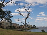
Mulwala is a town in the Corowa Shire
Local Government Area in the Riverina
district of New South Wales
, Australia
. The town is situated on Lake Mulwala
, an artificial lake formed by the damming of the Murray River
. At the 2006 census
, Mulwala had a population of 1,986 people. The town's name is derived from an aboriginal word for 'rain'.
is Mulwala's twin town of Yarrawonga
.
Mulwala is a popular destination for water sports and fishing
, especially for tourists from nearby Melbourne
, 300 kilometres (186.4 mi) to the south. Other popular attractions include three major licensed clubs.
The local Australian rules football
club, Mulwala Football Club
competes in the Murray Football League
.
 In 1847 James McRae arrived in the district to take charge of "Mulwala" and "Boroge" stations on behalf of the squatter Linbourne. McRae built a punt and a public house at the locality. He obtained a licence for his Travellers' Rest Hotel in 1853.
In 1858 Surveyor Adams marked out a township at the site. In 1866 a new hotel was opened at Mulwala and a school established at the township. Mulwala Post Office opened in 1864 for about six weeks, closed due to a large fire, and was reopened on 1 June 1866. The pioneer, James McRae, died in 1866.
In 1872 Mulwala was described as a small township of about 100 inhabitants, possessing a church, a school, a post-office and a public house.
In 1887 it was reported that Mulwala had two hotels and two stores; a court-house had been erected and a sawmill started.
In 1972, Mulwala was the site for a large outdoor pop music festival, which despite boasting big Australian names (Chain
, Doug Parkinson, Billy Thorpe and the Aztecs) and some overseas artists (Canned Heat
, Steven Stills & Manassas) , was considered a flop, after rain had washed out the site by the third day.
Corowa Shire Council
Corowa Shire is a local government area in New South Wales, Australia in the Riverina region. It is on the Murray River and the Riverina Highway.Its includes the towns of Corowa, Howlong, Balldale, Coreen and Daysdale, Rennie and Mulwala.- Council :...
Local Government Area in the Riverina
Riverina
The Riverina is an agricultural region of south-western New South Wales , Australia. The Riverina is distinguished from other Australian regions by the combination of flat plains, warm to hot climate and an ample supply of water for irrigation. This combination has allowed the Riverina to develop...
district of New South Wales
New South Wales
New South Wales is a state of :Australia, located in the east of the country. It is bordered by Queensland, Victoria and South Australia to the north, south and west respectively. To the east, the state is bordered by the Tasman Sea, which forms part of the Pacific Ocean. New South Wales...
, Australia
Australia
Australia , officially the Commonwealth of Australia, is a country in the Southern Hemisphere comprising the mainland of the Australian continent, the island of Tasmania, and numerous smaller islands in the Indian and Pacific Oceans. It is the world's sixth-largest country by total area...
. The town is situated on Lake Mulwala
Lake Mulwala
Lake Mulwala was created in 1939 by building a dam across the Murray River between Yarrawonga in Victoria and Mulwala in New South Wales to provide irrigation water for the surrounding district...
, an artificial lake formed by the damming of the Murray River
Murray River
The Murray River is Australia's longest river. At in length, the Murray rises in the Australian Alps, draining the western side of Australia's highest mountains and, for most of its length, meanders across Australia's inland plains, forming the border between New South Wales and Victoria as it...
. At the 2006 census
Census in Australia
The Australian census is administered once every five years by the Australian Bureau of Statistics. The most recent census was conducted on 9 August 2011; the next will be conducted in 2016. Prior to the introduction of regular censuses in 1961, they had also been run in 1901, 1911, 1921, 1933,...
, Mulwala had a population of 1,986 people. The town's name is derived from an aboriginal word for 'rain'.
Overview
Across the border in VictoriaVictoria (Australia)
Victoria is the second most populous state in Australia. Geographically the smallest mainland state, Victoria is bordered by New South Wales, South Australia, and Tasmania on Boundary Islet to the north, west and south respectively....
is Mulwala's twin town of Yarrawonga
Yarrawonga, Victoria
Yarrawonga is a town in the Shire of Moira Local Government Area in the Australian state of Victoria. The town is situated on the south bank of the Murray River, the border between Victoria and New South Wales and is located approximately north-east of the state capital, Melbourne. Yarrawonga's...
.
Mulwala is a popular destination for water sports and fishing
Angling
Angling is a method of fishing by means of an "angle" . The hook is usually attached to a fishing line and the line is often attached to a fishing rod. Fishing rods are usually fitted with a fishing reel that functions as a mechanism for storing, retrieving and paying out the line. The hook itself...
, especially for tourists from nearby Melbourne
Melbourne
Melbourne is the capital and most populous city in the state of Victoria, and the second most populous city in Australia. The Melbourne City Centre is the hub of the greater metropolitan area and the Census statistical division—of which "Melbourne" is the common name. As of June 2009, the greater...
, 300 kilometres (186.4 mi) to the south. Other popular attractions include three major licensed clubs.
The local Australian rules football
Australian rules football
Australian rules football, officially known as Australian football, also called football, Aussie rules or footy is a sport played between two teams of 22 players on either...
club, Mulwala Football Club
Mulwala Football Club
The Mulwala Football Club, nicknamed the Lions, is an Australian Rules Football club playing in the Murray Football League.The club is based in the town of Mulwala located in the Riverina district of New South Wales....
competes in the Murray Football League
Murray Football League
The Murray Football League is an Australian rules football league affiliated with the Victorian Country Football League.The league covers a large area of northern Victoria and southern New South Wales from Shepparton in the south to Deniliquin in the north.It covers much the same area as the...
.
History

In 1858 Surveyor Adams marked out a township at the site. In 1866 a new hotel was opened at Mulwala and a school established at the township. Mulwala Post Office opened in 1864 for about six weeks, closed due to a large fire, and was reopened on 1 June 1866. The pioneer, James McRae, died in 1866.
In 1872 Mulwala was described as a small township of about 100 inhabitants, possessing a church, a school, a post-office and a public house.
In 1887 it was reported that Mulwala had two hotels and two stores; a court-house had been erected and a sawmill started.
In 1972, Mulwala was the site for a large outdoor pop music festival, which despite boasting big Australian names (Chain
Chain (band)
Chain are an Australian blues band formed in Melbourne as The Chain in late 1968 with a lineup including guitarist, vocalist Phil Manning; they are sometimes known as Matt Taylor's Chain after lead singer-songwriter and harmonica player, Matt Taylor...
, Doug Parkinson, Billy Thorpe and the Aztecs) and some overseas artists (Canned Heat
Canned Heat
Canned Heat is a blues-rock/boogie rock band that formed in Los Angeles, California in 1965. The group has been noted for its own interpretations of blues material as well as for efforts to promote the interest in this type of music and its original artists...
, Steven Stills & Manassas) , was considered a flop, after rain had washed out the site by the third day.

