Murray Hill Tunnel
Encyclopedia


Park Avenue (Manhattan)
Park Avenue is a wide boulevard that carries north and southbound traffic in New York City borough of Manhattan. Through most of its length, it runs parallel to Madison Avenue to the west and Lexington Avenue to the east....
in the New York City
New York City
New York is the most populous city in the United States and the center of the New York Metropolitan Area, one of the most populous metropolitan areas in the world. New York exerts a significant impact upon global commerce, finance, media, art, fashion, research, technology, education, and...
borough
Borough (New York City)
New York City, one of the largest cities in the world, is composed of five boroughs. Each borough now has the same boundaries as the county it is in. County governments were dissolved when the city consolidated in 1898, along with all city, town, and village governments within each county...
of Manhattan
Manhattan
Manhattan is the oldest and the most densely populated of the five boroughs of New York City. Located primarily on the island of Manhattan at the mouth of the Hudson River, the boundaries of the borough are identical to those of New York County, an original county of the state of New York...
, leading towards Grand Central Terminal
Grand Central Terminal
Grand Central Terminal —often incorrectly called Grand Central Station, or shortened to simply Grand Central—is a terminal station at 42nd Street and Park Avenue in Midtown Manhattan in New York City, United States...
. It once carried the New York and Harlem Railroad
New York and Harlem Railroad
The New York and Harlem Railroad was one of the first railroads in the United States, and possibly also the world's first street railway. Designed by John Stephenson, it was opened in stages between 1832 and 1852 between Lower Manhattan to and beyond Harlem...
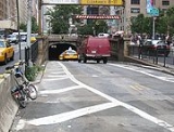
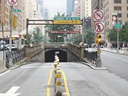
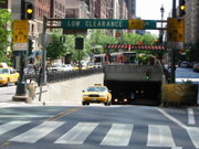
and later that company's streetcar line and was called the Murray Hill Tunnel. Due to the construction of Grand Central Terminal and the removal of tracks, the north end has been reconstructed for a steeper approach. It is now under the jurisdiction of the New York City Department of Transportation
New York City Department of Transportation
The New York City Department of Transportation is responsible for the management of much of New York City's transportation infrastructure...
, and carries one lane of northbound car traffic from East 33rd Street to East 40th Street. From 40th Street north, traffic can follow the Grand Central Terminal Park Avenue Viaduct
Grand Central Terminal Park Avenue Viaduct
The Grand Central Terminal Park Avenue Viaduct is a roadway that brings Park Avenue around Grand Central Terminal and the MetLife Building, the two buildings that interrupt Park Avenue's broad boulevard in the Manhattan borough of New York City...
. Prior to August 3, 2008, the tunnel carried two-way traffic, but was reconfigured to increase pedestrian safety.
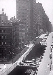
The tunnel was originally built as an open rock cut, completed in 1834, after which the NY&H Railroad was opened as far as Yorkville
Yorkville, Manhattan
Yorkville is a neighborhood in the greater Upper East Side, in the Borough of Manhattan in New York City. Yorkville's boundaries include: the East River on the east, 96th Street on the north, Third Avenue on the west and 72nd Street to the south. However, its southern boundary is a subject of...
, to 85th Street. In the 1850s the cut was roofed over, using granite stringers from the original railroad bed south of 14th Street
14th Street (Manhattan)
14th Street is a major crosstown street in the New York City borough of Manhattan. The street rivals the size of some of the well-known avenues of the city and is an important business location....
, thus creating the present tunnel. The vertical clearance is 8 feet 11 inches (2.71 m).
The New York City Subway
New York City Subway
The New York City Subway is a rapid transit system owned by the City of New York and leased to the New York City Transit Authority, a subsidiary agency of the Metropolitan Transportation Authority and also known as MTA New York City Transit...
runs beneath the tunnel. Only the two center express tracks of the Lexington Avenue Line
IRT Lexington Avenue Line
The Lexington Avenue Line is one of the lines of the IRT division of the New York City Subway, stretching from Downtown Brooklyn or Lower Manhattan north to 125th Street in East Harlem. The portion in Lower and Midtown Manhattan was part of the first subway line in New York...
are directly below and therefore are a few feet lower than the two outer tracks.

