Nafferton
Encyclopedia
Nafferton is a village and civil parish in the East Riding of Yorkshire
, England. It is situated approximately 2 miles (3.2 km) north east of Driffield
town centre and lies just south of the A614 road
.
It is served by Nafferton railway station
on the Yorkshire Coast Line
from Hull
to Scarborough. According to the 2001 UK census
, Nafferton parish had a population of 2,184.
Nattfari: a personal name
ton: farm
hence, Nattfari's farm.
Nafferton is listed in the Domesday Book
as "Nadfartone". The present name came into use in the thirteenth century.
 Archaeological evidence for settlement in the area dates back to the mesolithic. Early hunter-gatherers established temporary camp sites throughout the area, subsisting from woodlands foraging, deer, boars, bears, and wild cattle.
The nearby Yorkshire Wolds
were later the site of substantial human activity during the neolithic and the area features burial mounds, with frequent finds of lithic technology.
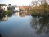
The oldest surviving building in the village is the church, parts of which date from the 13th century. The mere, a large expanse of water fed by natural springs was formerly a mill pond.
East Riding of Yorkshire
The East Riding of Yorkshire, or simply East Yorkshire, is a local government district with unitary authority status, and a ceremonial county of England. For ceremonial purposes the county also includes the city of Kingston upon Hull, which is a separate unitary authority...
, England. It is situated approximately 2 miles (3.2 km) north east of Driffield
Driffield
Driffield, also known as Great Driffield, is a market town and civil parish in the East Riding of Yorkshire, England. The civil parish is formed by the town of Driffield and the village of Little Driffield....
town centre and lies just south of the A614 road
A614 road
The A614 is a main road in England running through the counties of Nottinghamshire, South Yorkshire and the East Riding of Yorkshire.Beginning at Redhill, near Calverton in Nottinghamshire at a roundabout with the A60, the road meets the A6097 at a junction which looks like a roundabout but...
.
It is served by Nafferton railway station
Nafferton railway station
Nafferton railway station serves the village of Nafferton in the East Riding of Yorkshire, England. It is located on the Yorkshire Coast Line and is operated by Northern Rail that provides all passenger train services. It was built for the rail magnate George Hudson who lived nearby and was "an...
on the Yorkshire Coast Line
Yorkshire Coast Line
The Yorkshire Coast Line is a railway line in northern England. It runs northwards from Hull Paragon to Bridlington and Scarborough calling at other intermediate stations.-History:...
from Hull
Kingston upon Hull
Kingston upon Hull , usually referred to as Hull, is a city and unitary authority area in the ceremonial county of the East Riding of Yorkshire, England. It stands on the River Hull at its junction with the Humber estuary, 25 miles inland from the North Sea. Hull has a resident population of...
to Scarborough. According to the 2001 UK census
United Kingdom Census 2001
A nationwide census, known as Census 2001, was conducted in the United Kingdom on Sunday, 29 April 2001. This was the 20th UK Census and recorded a resident population of 58,789,194....
, Nafferton parish had a population of 2,184.
Toponomy
The name Nafferton derives from Old Scandinavian: -Nattfari: a personal name
ton: farm
hence, Nattfari's farm.
Nafferton is listed in the Domesday Book
Domesday Book
Domesday Book , now held at The National Archives, Kew, Richmond upon Thames in South West London, is the record of the great survey of much of England and parts of Wales completed in 1086...
as "Nadfartone". The present name came into use in the thirteenth century.
History

The nearby Yorkshire Wolds
Yorkshire Wolds
The Yorkshire Wolds are low hills in the counties of East Riding of Yorkshire and North Yorkshire in northeastern England. The name also applies to the district in which the hills lie....
were later the site of substantial human activity during the neolithic and the area features burial mounds, with frequent finds of lithic technology.
The oldest surviving building in the village is the church, parts of which date from the 13th century. The mere, a large expanse of water fed by natural springs was formerly a mill pond.

