Narkanda
Encyclopedia
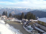
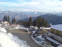
Narkanda is a town and a nagar panchayat
in Shimla district
in the Indian state of Himachal Pradesh
. It is at an altitude of 2708 meters on the Hindustan-Tibet Road (NH 22) in Himachal Pradesh
, India
. It is about 65 km from Shimla
and surrounded by the Shivalik Ranges that span a large part of Himachal Pradesh.
 It is a skiing resort in winter. It connects Shimla
with Rampur
and a detour also goes to Thanedhar, the prime apple belt of Himachal Pradesh
where Satyananda Stokes
started the apple culture.
, Narkanda had a population of 2712. Males constitute 62% of the population and females 38%. Narkanda has an average literacy rate of 80%, higher than the national average of 59.5%: male literacy is 85%, and female literacy is 72%. In Narkanda, 15% of the population is under 6 years of age.
Nagar Panchayat
A nagar palika or nagar panchayat is a form of an urban political unit in India comparable to a municipality.An urban centre with more than 30,000 and less than 100,000 inhabitants is classified as a nagar panchayat....
in Shimla district
Shimla district
Shimla district of Himachal Pradesh, lies between the longitude 77.00" and 78.19" east and latitude 30.45" and 31.44" north, has its headquarters at Shimla city. It is surrounded by Mandi and Kullu in the north, Kinnaur in the east, Uttarakhand in the south, Sirmaur in the west...
in the Indian state of Himachal Pradesh
Himachal Pradesh
Himachal Pradesh is a state in Northern India. It is spread over , and is bordered by the Indian states of Jammu and Kashmir on the north, Punjab on the west and south-west, Haryana and Uttar Pradesh on the south, Uttarakhand on the south-east and by the Tibet Autonomous Region on the east...
. It is at an altitude of 2708 meters on the Hindustan-Tibet Road (NH 22) in Himachal Pradesh
Himachal Pradesh
Himachal Pradesh is a state in Northern India. It is spread over , and is bordered by the Indian states of Jammu and Kashmir on the north, Punjab on the west and south-west, Haryana and Uttar Pradesh on the south, Uttarakhand on the south-east and by the Tibet Autonomous Region on the east...
, India
India
India , officially the Republic of India , is a country in South Asia. It is the seventh-largest country by geographical area, the second-most populous country with over 1.2 billion people, and the most populous democracy in the world...
. It is about 65 km from Shimla
Shimla
Shimla , formerly known as Simla, is the capital city of Himachal Pradesh. In 1864, Shimla was declared the summer capital of the British Raj in India. A popular tourist destination, Shimla is often referred to as the "Queen of Hills," a term coined by the British...
and surrounded by the Shivalik Ranges that span a large part of Himachal Pradesh.

Shimla
Shimla , formerly known as Simla, is the capital city of Himachal Pradesh. In 1864, Shimla was declared the summer capital of the British Raj in India. A popular tourist destination, Shimla is often referred to as the "Queen of Hills," a term coined by the British...
with Rampur
Rampur, Himachal Pradesh
Rampur Bushahr is a city and a municipal council in Shimla district in the Indian state of Himachal Pradesh. It is 130 km from Shimla well connected with National Highway which passes through Narkanda .-History:...
and a detour also goes to Thanedhar, the prime apple belt of Himachal Pradesh
Himachal Pradesh
Himachal Pradesh is a state in Northern India. It is spread over , and is bordered by the Indian states of Jammu and Kashmir on the north, Punjab on the west and south-west, Haryana and Uttar Pradesh on the south, Uttarakhand on the south-east and by the Tibet Autonomous Region on the east...
where Satyananda Stokes
Satyananda Stokes
Satyananda Stokes was an American who moved to India and adopted it as his own country. Stokes' given name was Samuel Evans Stokes, Jr., and belonging to a prominent family and was the son of a successful businessman who pioneered elevators in America he came to India in 1904 to work at a leper...
started the apple culture.
Geography
Narkanda is located at 31.27°N 77.45°E. It has an average elevation of 2621 metres (8599 feet). Hatu Peak which is at 11000 ft is 5 km from Narkanda. Kotgarh is 16 km from Narkanda and famous for apple orchards. Satyanand Stokes brought the apple to this place and helped strengthen the economy of this area. Today Rs 3,000 Crore direct and indirect income is generated through apple production.Presently apple growers are shifting to bring their farm under cherry cultivation to fetch fast money in their pocket as holdings are marginalised due to population factor.The grandson of Mr. Stokes is experimenting to develop new variety of apple for better production.Demographics
India censusCensus
A census is the procedure of systematically acquiring and recording information about the members of a given population. It is a regularly occurring and official count of a particular population. The term is used mostly in connection with national population and housing censuses; other common...
, Narkanda had a population of 2712. Males constitute 62% of the population and females 38%. Narkanda has an average literacy rate of 80%, higher than the national average of 59.5%: male literacy is 85%, and female literacy is 72%. In Narkanda, 15% of the population is under 6 years of age.

