

National Register of Historic Places listings in Baker County, Oregon
Encyclopedia
This is a list of properties and districts in Baker County, Oregon
that are listed on the National Register of Historic Places
.
Baker County, Oregon
Baker County is a county located in the U.S. state of Oregon. It is included in the 8 county definition of Eastern Oregon. It is named for Edward Dickinson Baker, a senator from Oregon who was killed at Ball's Bluff, a battle of the Civil War in Virginia in 1861. It was split from the eastern part...
that are listed on the National Register of Historic Places
National Register of Historic Places
The National Register of Historic Places is the United States government's official list of districts, sites, buildings, structures, and objects deemed worthy of preservation...
.
Current listings
| Landmark name | Image | Date listed | LocationCoordinates: Except as otherwise noted, all entries are drawn from Google Earth Google Earth Google Earth is a virtual globe, map and geographical information program that was originally called EarthViewer 3D, and was created by Keyhole, Inc, a Central Intelligence Agency funded company acquired by Google in 2004 . It maps the Earth by the superimposition of images obtained from satellite... KMZ files available at: |
City or Town | Summary | |
|---|---|---|---|---|---|---|
| 1 | Antlers Guard Station Antlers Guard Station The Antlers Guard Station is a rustic cabin located in the Wallowa–Whitman National Forest in northeastern Oregon, United States. It was originally built to house fire crews assigned to patrol the surrounding National Forest. Since the 1990s, the United States Forest Service rents Antlers Guard... |
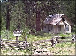 |
Southeast of Whitney in the Wallowa-Whitman National Forest 44°38′00.23"N 118°16′45.06"W |
Unity Unity, Oregon Unity is a city in Baker County, Oregon, United States, located in the Burnt River Valley. The population was 131 at the 2000 census.-History:While the town was never platted, a post office was established in Unity in 1891... |
||
| 2 | Baker Historic District Baker Historic District The Baker Historic District, located in Baker City, Oregon, is listed on the National Register of Historic Places.... |
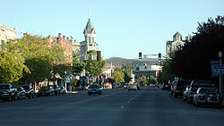 |
Along Main Street 44.77482°N 117.8314°W |
Baker City Baker City, Oregon Baker City is a city in and the county seat of Baker County, Oregon, United States. It was named after Edward D. Baker. The population was 9,828 at the 2010 census.-History:... |
||
| 3 | Baker Municipal Natatorium Baker Municipal Natatorium The Baker Municipal Natatorium, located in Baker City, Oregon, is listed on the National Register of Historic Places.... |
image pending | 2470 Grove Street 44.78133°N 117.8259°W |
Baker City Baker City, Oregon Baker City is a city in and the county seat of Baker County, Oregon, United States. It was named after Edward D. Baker. The population was 9,828 at the 2010 census.-History:... |
||
| 4 | Churchill School Churchill School The Churchill School, located in Baker City, Oregon, is listed on the National Register of Historic Places.... |
image pending | 3451 Broadway Street 44°46′39.39"N 117°50′57.35"W |
Baker City Baker City, Oregon Baker City is a city in and the county seat of Baker County, Oregon, United States. It was named after Edward D. Baker. The population was 9,828 at the 2010 census.-History:... |
||
| 5 | Robert F. and Elizabeth Clark House Robert F. and Elizabeth Clark House The Robert F. and Elizabeth Clark House, located in Baker City, Oregon, is a house listed on the National Register of Historic Places.... |
image pending | 1522 Washington Avenue 44.77711°N 117.8237°W |
Baker City Baker City, Oregon Baker City is a city in and the county seat of Baker County, Oregon, United States. It was named after Edward D. Baker. The population was 9,828 at the 2010 census.-History:... |
||
| 6 | James O. Maxwell Farmstead James O. Maxwell Farmstead The James O. Maxwell Farmstead, located in Haines, Oregon, is listed on the National Register of Historic Places.... |
image pending | Muddy Creek Road, Route 2, Box 82 44.93802°N 117.9939°W |
Haines Haines, Oregon Haines is a city in Baker County, Oregon, United States. The population was 426 at the 2000 census.-History:Haines was platted in 1885 or 1886 along the Oregon Railway and Navigation Company rail line, having been a stage stop before then.-Geography:... |
||
| 7 | Oregon Commercial Company Building Oregon Commercial Company Building The Oregon Commercial Company Building, in Huntington, Baker County, Oregon, United States, was built in 1890.The building was added to the National Register of Historic Places in 1992.... |
image pending | 40-50 E. Washington Street 44°21′04.31"N 117°16′03.20"W |
Huntington Huntington, Oregon Huntington is a city in Baker County, on the eastern border of Oregon, United States. It is located on the Snake River and along Interstate 84 and U.S. Route 30. The population was 515 at the 2000 census.- History:... |
||
| 8 | Ed Rand House Ed Rand House The Ed Rand House, located in Baker City, Oregon, is a house listed on the National Register of Historic Places.... |
image pending | 1700 4th Street 44.77457°N 117.8344°W |
Baker City Baker City, Oregon Baker City is a city in and the county seat of Baker County, Oregon, United States. It was named after Edward D. Baker. The population was 9,828 at the 2010 census.-History:... |
||
| 9 | St. Elizabeth Hospital (Old) | image pending | 2365 4th Street 44.7805°N 117.8344°W |
Baker City Baker City, Oregon Baker City is a city in and the county seat of Baker County, Oregon, United States. It was named after Edward D. Baker. The population was 9,828 at the 2010 census.-History:... |
||
| 10 | Sumpter Valley Gold Dredge Sumpter Valley Gold Dredge The Sumpter Valley Gold Dredge is a historic gold dredge located in Sumpter, Oregon, United States. The dredge was built during the gold rush that consumed most of the western states throughout the mid-19th century. Gold was discovered in Sumpter in 1862, but the advent of using a large machine to... |
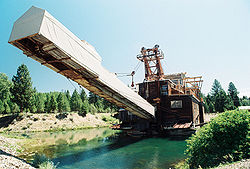 |
Southwest of Sumpter near Cracker Creek 44.74155°N 118.2038°W |
Sumpter Sumpter, Oregon Sumpter is a city in Baker County, Oregon, United States. The population was 171 at the 2000 census. Sumpter is named after Fort Sumter by its founders.- History :... |
Gold dredge Gold dredge A gold dredge is a placer mining machine that extracts gold from sand, gravel, and dirt using water and mechanical methods.The original gold dredges were large, multi-story machines built in the first half of the 1900s.... used in placer mining Placer mining Placer mining is the mining of alluvial deposits for minerals. This may be done by open-pit or by various surface excavating equipment or tunneling equipment.... along the Powder River Powder River (Oregon) The Powder River is a tributary of the Snake River, approximately long, in northeast Oregon in the United States. It drains an area of the Columbia Plateau on the eastern side of the Blue Mountains... beginning in the 1930s, representing a late, highly-mechanized phase of gold mining in Eastern Oregon. |
|
| 11 | Sumpter Valley Railway Historic District Sumpter Valley Railway The Sumpter Valley Railway is a heritage railroad located in Baker County, in the U.S. state of Oregon. Built on a right-of-way used by the original railway of the same name, it carries excursion trains on a roughly route between McEwen and Sumpter. The railroad has two steam locomotives and... |
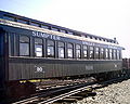 |
Roughly between Baker and Prairie City starting near the McEwen station site and west to the Dixie Pass area 44.62038°N 118.3352°W |
Baker City Baker City, Oregon Baker City is a city in and the county seat of Baker County, Oregon, United States. It was named after Edward D. Baker. The population was 9,828 at the 2010 census.-History:... to Prairie City Prairie City, Oregon Prairie City is a city in Grant County, Oregon, United States. The population was 1,080 at the 2000 census. The community was incorporated by the Oregon Legislative Assembly on February 23, 1891.-History:... |
||
| 12 | Superintendent's House Superintendent's House (Sumpter, Oregon) The Superintendent's House, also known as the Oliver C. and L. Mae Wright House, is a house located in Sumpter, Oregon listed on the National Register of Historic Places.... |
image pending | 271 Mill Street 44.74403°N 118.2019°W |
Sumpter Sumpter, Oregon Sumpter is a city in Baker County, Oregon, United States. The population was 171 at the 2000 census. Sumpter is named after Fort Sumter by its founders.- History :... |
||
| 13 | Unity Ranger Station Unity Ranger Station The Unity Ranger Station is a United States Forest Service compound consisting of five buildings and a lookout tower in the Wallowa-Whitman National Forest of northeastern Oregon. For many years, it was the administrative headquarters for the Unity Ranger District. It is located in the small... |
44.43678°N 118.188°W | Unity Unity, Oregon Unity is a city in Baker County, Oregon, United States, located in the Burnt River Valley. The population was 131 at the 2000 census.-History:While the town was never platted, a post office was established in Unity in 1891... |