

National Register of Historic Places listings in Grant County, Oregon
Encyclopedia
This is a list of properties and districts in Grant County, Oregon
that are listed on the National Register of Historic Places
.
Grant County, Oregon
Grant County is a county located in the U.S. state of Oregon. It is included in the 8 county definition of Eastern Oregon. In 2010, its population was 7,445. It is named for President Ulysses S. Grant, who served as an army officer in the Oregon Territory, and at the time of the county's creation...
that are listed on the National Register of Historic Places
National Register of Historic Places
The National Register of Historic Places is the United States government's official list of districts, sites, buildings, structures, and objects deemed worthy of preservation...
.
Current listings
| Landmark name | Image | Date listed | LocationCoordinates: Except as otherwise noted, all entries are drawn from Google Earth Google Earth Google Earth is a virtual globe, map and geographical information program that was originally called EarthViewer 3D, and was created by Keyhole, Inc, a Central Intelligence Agency funded company acquired by Google in 2004 . It maps the Earth by the superimposition of images obtained from satellite... KMZ files available at: |
City or Town | Summary | |
|---|---|---|---|---|---|---|
| 1 | Advent Christian Church | image pending | 261 W. Main Street 44.41652°N 118.9552°W |
John Day John Day, Oregon John Day is a city located about north of Canyon City in Grant County, Oregon, at the intersection of U.S. Routes 26 and 395. The city was named for the nearby John Day River, which had been named for a Virginian member of the 1811 Astor Expedition, John Day... |
||
| 2 | James Cant Ranch Historic District James Cant Ranch Historic District The James Cant Ranch is a pioneer ranch complex in Grant County in eastern Oregon, United States. The ranch is located on both sides of the John Day River in the John Day Fossil Beds National Monument. The ranch was originally homesteaded by Floyd Officer in 1890. Officer sold the property to... |
Along Oregon Route 19 Oregon Route 19 Oregon Route 19 is an Oregon state highway in the north-central part of the state. It runs from Interstate 84 at Arlington in the Columbia River Gorge to a junction with U.S. Route 26 in Grant County, near the Sheep Rock Unit of the John Day Fossil Beds National Monument. Oregon Route 19 is the... 44°33′19"N 119°38′41"W |
Dayville Dayville, Oregon Dayville is a city in Grant County, Oregon, United States. It was incorporated in 1913. The population was 138 at the 2000 census.-Geography:According to the United States Census Bureau, the city has a total area of , all land.... |
|||
| 3 | Fremont Powerhouse | image pending | Along Forest Road 10 44.78175°N 118.5709°W |
Granite Granite, Oregon Granite is a city located in Grant County, Oregon, United States. As of the 2000 census, the city had a total population of 24, up from its population of 10 in 1990... |
||
| 4 | John Day Compound, Supervisor's Warehouse | image pending | Malheur National Forest 44.41825°N 118.9598°W |
John Day John Day, Oregon John Day is a city located about north of Canyon City in Grant County, Oregon, at the intersection of U.S. Routes 26 and 395. The city was named for the nearby John Day River, which had been named for a Virginian member of the 1811 Astor Expedition, John Day... |
||
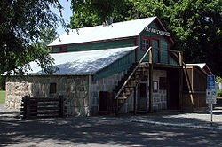
| 5 | Kam Wah Chung Company Building Kam Wah Chung & Co. Museum The Kam Wah Chung & Co. Museum, also known as Kam Wah Chung Company Building, is a state park and National Historic Landmark in John Day, Oregon that preserves early Chinese culture in Oregon... |
 |
John Day City Park 44°25′07"N 118°57′25"W |
John Day John Day, Oregon John Day is a city located about north of Canyon City in Grant County, Oregon, at the intersection of U.S. Routes 26 and 395. The city was named for the nearby John Day River, which had been named for a Virginian member of the 1811 Astor Expedition, John Day... |
The best known example of a Chinese Overseas Chinese Overseas Chinese are people of Chinese birth or descent who live outside the Greater China Area . People of partial Chinese ancestry living outside the Greater China Area may also consider themselves Overseas Chinese.... mercantile Retailing Retail consists of the sale of physical goods or merchandise from a fixed location, such as a department store, boutique or kiosk, or by mail, in small or individual lots for direct consumption by the purchaser. Retailing may include subordinated services, such as delivery. Purchasers may be... and herb Herbalism Herbalism is a traditional medicinal or folk medicine practice based on the use of plants and plant extracts. Herbalism is also known as botanical medicine, medical herbalism, herbal medicine, herbology, herblore, and phytotherapy... store in the United States United States The United States of America is a federal constitutional republic comprising fifty states and a federal district... . It embodies the role of immigrant Immigration Immigration is the act of foreigners passing or coming into a country for the purpose of permanent residence... Chinese Chinese American Chinese Americans represent Americans of Chinese descent. Chinese Americans constitute one group of overseas Chinese and also a subgroup of East Asian Americans, which is further a subgroup of Asian Americans... in the post-Civil War American Civil War The American Civil War was a civil war fought in the United States of America. In response to the election of Abraham Lincoln as President of the United States, 11 southern slave states declared their secession from the United States and formed the Confederate States of America ; the other 25... expansion Expansionism In general, expansionism consists of expansionist policies of governments and states. While some have linked the term to promoting economic growth , more commonly expansionism refers to the doctrine of a state expanding its territorial base usually, though not necessarily, by means of military... period of the western United States Western United States .The Western United States, commonly referred to as the American West or simply "the West," traditionally refers to the region comprising the westernmost states of the United States. Because the U.S. expanded westward after its founding, the meaning of the West has evolved over time... . |
|
| 6 | St. Thomas' Episcopal Church | 135 Washington Street 44.38828°N 118.9492°W |
Canyon City Canyon City, Oregon Canyon City is a city in Grant County, Oregon, United States. It is the county seat of Grant County, and is about a mile south of John Day on U.S. Highway 395. As of the 2010 census, the city had a total population of 703.-History:... |
|||
| 7 | Sumpter Valley Railway Historic District Sumpter Valley Railway The Sumpter Valley Railway is a heritage railroad located in Baker County, in the U.S. state of Oregon. Built on a right-of-way used by the original railway of the same name, it carries excursion trains on a roughly route between McEwen and Sumpter. The railroad has two steam locomotives and... |
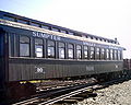 |
Roughly between Baker and Prairie City starting near the McEwen station site and west to the Dixie Pass area 44.62038°N 118.3352°W |
Prairie City Prairie City, Oregon Prairie City is a city in Grant County, Oregon, United States. The population was 1,080 at the 2000 census. The community was incorporated by the Oregon Legislative Assembly on February 23, 1891.-History:... to Baker City Baker City, Oregon Baker City is a city in and the county seat of Baker County, Oregon, United States. It was named after Edward D. Baker. The population was 9,828 at the 2010 census.-History:... |
||
| 8 | Sumpter Valley Railway Passenger Station Sumpter Valley Railway Passenger Station Sumpter Valley Railway Passenger Station was the westernmost station on the Sumpter Valley Railway, which ran from Baker City to Prairie City in the U.S. state of Oregon. The line reached Prairie City in 1910 but was abandoned in 1933, and the station became a private dwelling... |
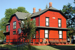 |
Main and Bridge Streets 44.45739°N 118.7075°W |
Prairie City Prairie City, Oregon Prairie City is a city in Grant County, Oregon, United States. The population was 1,080 at the 2000 census. The community was incorporated by the Oregon Legislative Assembly on February 23, 1891.-History:... |
||
| 9 | Sumpter Valley Railway, Middle Fork–John Day River | image pending | Sumpter Valley Railway's Middle Fork Spur between Bates and Susanville 44.64102°N 118.6969°W |
Bates Bates, Oregon Bates is an unincorporated community in Grant County, Oregon, United States. Although it is unincorporated, it has a post office with a ZIP code of 97817.Bates was a lumber mill town until 1975 with a population of up to 400. Bates State Park opened in 2011.... to Susanville Susanville, Oregon Susanville is an unincorporated community in Grant County, Oregon, United States, in the Blue Mountains about two miles up Elk Creek from Galena. The place was started as a gold mining camp in 1862 or 1864 and is now considered a ghost town.-History:... |
||
| 10 | Supervisor's House No. 1001 | image pending | Malheur National Forest 44.41166°N 118.95°W |
John Day John Day, Oregon John Day is a city located about north of Canyon City in Grant County, Oregon, at the intersection of U.S. Routes 26 and 395. The city was named for the nearby John Day River, which had been named for a Virginian member of the 1811 Astor Expedition, John Day... |