
Near South Side, Chicago
Encyclopedia
The Near South Side is a community area
of Chicago in Cook County
, Illinois
, United States. It is located just south of the downtown central business district, the Loop
, which is itself a community area
. The Near South Side's boundaries (see map) are as follows: North—Roosevelt Road (1200 S); South—26th Street; West—Chicago River
between Roosevelt and 18th Street, Clark Street
between 18th Street and 22nd Street, Federal between 22nd and the Stevenson Expressway
just south of 25th Street, and Clark Street again between the Stevenson
and 26th Street; and East—Lake Michigan
.
The portion of the Near South Side located near Lake Shore Drive
contains some of the most well-known structures in Chicago: Soldier Field
, the home of the National Football League
Chicago Bears
; McCormick Place
, Chicago's primary convention center; the Museum Campus, which contains the Field Museum
, the Shedd Aquarium
, and the Adler Planetarium
; and Northerly Island
. The remaining area is currently undergoing a major residential and mixed-use redevelopment. As part of the Chicago 2016 Olympic bid
, the Olympic Village
was planned to be located on a 37 acres (149,733.8 m²) truck parking lot south of McCormick Place that is mostly in the Douglas
community area
and partly in the Near South Side.
 The Near South Side is one of the most dynamic of Chicago's communities. It has undergone a metamorphosis from a Native American
homeland to a blue collar settlement, to an elite socialite residential district, to a center for vice, to a slum, to a public housing and warehouse district, and finally to the home of a newly gentrified residential district.
. This area was first populated by settlers working for the Illinois & Michigan Canal, who subsequently worked in the lumber district. Proximity to the railroads attracted light manufacturing and shops. In 1853, the community was absorbed by the extension of the city limits to 31st Street. In 1859, a South State Street
horse-drawn streetcar line, linking the area to downtown, attracted wealthy families to the area. By the time of the Great Chicago Fire
in 1871, it was home to some of the city's finest mansions and most elite social families. However, by the turn of the century, rapid transit evolved and many families moved slightly farther from the Loop business district. The railroads brought warehouses and light manufacturing. Michigan Avenue
between 14th Street and 22nd Street became "Auto Row". The "Levee" vice district of brothel
s and gambling dens around Cermak Street and State Street prospered until 1912. Burnham Park
and several accompanying institutions were built in the 1910s and 1920s. World War I
and post World War I
Great Migration
settlers moved in and created the low-rent "Black Belt". Urban renewal and public housing projects later replaced some of the slums. In the 1940s, some of the city’s slums were on the Near South Side.
International Exposition was the name of the World's Fair held on the Near South Side lakefront from 1933 to 1934 to celebrate the city's centennial. The theme of the fair was technological innovation over the century since Chicago's founding. More than 40 million people visited the fair, which symbolized for many hope for Chicago and the nation, then in the midst of the Great Depression
.
 West of Lake Shore Drive
, much of the Near South Side, in the middle of the twentieth century, consisted largely of railroad tracks and interchanges until the 1960s, when middle-class housing developments were built in the community area. In 1977, George Halas
surrendered 51 acres (206,389.9 m²) of railyards for redevelopment as Dearborn Park apartments, townhouses and accompanying tree-lined walkways. In 1988, the second phase of Dearborn Park construction began between State St. and Clark St., south of Roosevelt Rd. A housing boom emerged in the 1990s and continues to the present day with the construction of many new condominium and apartment towers.
Construction of the Central Station
development commenced in 1990. This was a mixed-use development on 72 acres (291,373.9 m²) of former rail yards and air rights east of Indiana Avenue between Roosevelt Road and 18th Street. Simultaneously, loft conversion spread to the warehouses and light manufacturing structures along the major north-south Avenues of Michigan, Indiana, and Wabash, which returned them to residential properties 100 years after the flight of the elite Chicago socialites. Among the prominent buildings are One Museum Park
and One Museum Park West
along a redeveloped Prairie Avenue
.
for more information
Landfill use created Burnham Park and Northerly Island
in the 1920s and 1930s along Lake Michigan
. The Field Museum of Natural History
, Soldier Field
, Adler Planetarium
and the John G. Shedd Aquarium were constructed on this newly reclaimed land
this time. Later, Merrill C. Meigs Field Airport was built. Northerly Island
connects to the rest of the Museum Campus through a narrow isthmus along Solidarity Drive dominated by Neoclassical sculptures of Kościuszko, Havliček
and Nicolaus Copernicus
.
The newly developed Central Station area includes three park areas. Mark Twain Park lies between South Indiana Avenue and Lake Shore Drive at 15th Place. Daniel Webster Park is bounded by 14th Street, South Indiana Avenue and townhouse developments. The Grant Park Extension lies east of One Museum Park
and South of Roosevelt. The developers donated 1.5 acres (6,070.3 m²) for one park to the city and developed the other two as part of its approval process. The donated tract protects the northward view of Grant Park.
, a huge exposition and convention complex at 23rd Street and Lake Shore Drive named for newspaper magnate Robert R. McCormick
. The original building burned in 1967, and was rebuilt and reopened in 1971 at the behest of mayor Richard J. Daley
. Large expansions were added in 1986, 1997 and 2007. The current redevelopment includes greatly expanded hotel accommodation. McCormick Place also houses the Arie Crown Theater
, and it is the annual location for the Chicago Auto Show
.
(with both the John J. Glessner House
and the Henry B. Clarke House
) and the historic (former) R. R. Donnelley & Sons printing company building (which now houses network routers and switches for much of the city). The Glessner House, which is perhaps the best known historic structure in this district, is now a museum. William Wallace Kimball's home is now home to the United States Soccer Federation
headquarters. Formerly, several important residences were located in this region. Additionally, the Fort Dearborn Massacre sculpture was on the property of the George Pullman
residence as a tribute to the massacre, which occurred in the neighborhood. Most of the Prairie Avenue
families worshiped at the Second Presbyterian Church of Chicago
.
Adler Planetarium
, R.R. Donnelley and Sons Co. Calumet Plant
, Henry B. Clarke House
, Coca Cola Company Building (on Wabash), Field Museum of Natural History
, John J. Glessner House
, William W. Kimball House, Maxwell-Briscoe Automobile Company Showroom, Quinn Chapel AME Church
, Harriet F. Rees House, Reid House, St. Luke's Hospital Complex, Second Presbyterian Church, Shedd Aquarium
, Soldier Field
, and Wheeler-Kohn House
are all located in the community area and are all listed on the National Register of Historic Places
(NRHP). Raymond M. Hilliard Center Historic District, Motor Row District
, and Prairie Avenue District
are districts largely within the community area that are also listed on the NRHP.
 Beginning in the mid-1990s, factories started being replaced with or converted to loft condominiums. The redevelopment continued through the early 2000s decade. South Loop residential development has expanded to the Dearborn Park neighborhood (between State and Clark Streets South of Roosevelt Road). The new Central Station neighborhood
is the site of major mixed use development that includes One Museum Park
, One Museum Park West
, numerous residential condominiums and luxury townhomes. This development is built on 72 acres (291,373.9 m²) of former rail yards and air space rights east of Indiana Avenue between Roosevelt Road and 18th Street that include the former location of the Central Station terminal. Also, a wave of loft conversions in Printer's Row that has spread to major North-South Avenues such as Michigan, Wabash, and Indiana is making them residential streets again in this neighborhood after a century of other uses. The planned development has expanded from 69 to 80 acres (323,748.8 m²) and includes properties between Michigan and Indiana Avenues. In 2006, the Prairie District Neighborhood Alliance
, a non-profit organization was formed to provide representation for thousands of South Loop residents, including the Prairie District, Central Station and Museum Park, Motor Row, the South Michigan Ave Corridor, as well as other areas of the Near South Side.
was reconstructed in 1996 so that it no longer cut through the Museum Campus. Previously the northbound lane ran east of Soldier Field. After reconstruction both lanes ran west of Soldier Field.
Its northern boundary (Roosevelt Road) marks the end of consecutively named east-west streets. East-west streets north of Roosevelt Road have street names except between State Street
and Michigan Avenue
. There are two block-long 8th and 11th Streets and a four-block 9th Street. Most streets south of Roosevelt simply use street numbers. Streets in this neighborhood from 13th to 26th are mostly numbered. Cullerton St (20th Street) & Cermak Road (22nd Street) are two of the few named east-west cross streets. Numbering continues southward in Chicago into the upper hundreds at a pace of 8 blocks per mile.
 Showing that neighborhood line drawing is sometimes imprecise, there is some confusion regarding where the South Loop neighborhood (which incorporates Printer's Row) is begins and ends. Some sources do not define its northern boundary, while defining its southern boundary as Cermak Street (22nd Street) and its western boundary as Canal Street. The Prairie District Neighborhood Alliance
, a not-for-profit neighborhood organization, has grown to provide support and representation to thousands of residents living in and around the South Loop and Near South Side of Chicago, including the Prairie Avenue District, Central Station and Museum Park, Motor Row and the South Michigan Avenue corridor, but the organization does not exclude those that are part of the broader South Loop and Near South Side community. The Greater South Loop Association represents residents living between Congress to the North, the Chicago River
to the west and the Stevenson Expressway (approximately 25th Street) to the south. South Loop Neighbors serves residents only as far South as "approximately" 15th Street and as far west as the river. Fodor's
has its own definition of the South Loop as the area bounded by Cermak, Michigan Avenue
, the Chicago River
, and Congress Parkway-Eisenhower Expressway. The South Loop is described as the neighborhood immediately south of "the Loop", yet "the Loop" has multiple meanings. The Loop
is a community area bounded by the Chicago River
, Lake Michigan
and Roosevelt Road. However, the term is also used to refer to the specific area bounded by the circular portion of the Chicago Transit Authority
's L Train
, which goes as far south as Van Buren Street or Congress Avenue (and this is described as the northern border of Printer's Row and the South Loop). Some primary sources cite Printer's Row and the South Loop as part of the Near South Side community area
. This transit-related area is the northern portion of the community area. Saying it is south of the former places it in the Near South Side, while saying it is part of the latter places it in the Loop. The Official City of Chicago Loop Map supports the latter.
 Residents are zoned to schools in Chicago Public Schools
. K-8 schools serving sections of the Near South Side include Drake School, National Teacher Academy, and South Loop School. Phillips Academy High School is the zoned high school of the Near South Side.
Community areas of Chicago
Community areas in Chicago refers to the work of the Social Science Research Committee at University of Chicago which has unofficially divided the City of Chicago into 77 community areas. These areas are well-defined and static...
of Chicago in Cook County
Cook County, Illinois
Cook County is a county in the U.S. state of Illinois, with its county seat in Chicago. It is the second most populous county in the United States after Los Angeles County. The county has 5,194,675 residents, which is 40.5 percent of all Illinois residents. Cook County's population is larger than...
, Illinois
Illinois
Illinois is the fifth-most populous state of the United States of America, and is often noted for being a microcosm of the entire country. With Chicago in the northeast, small industrial cities and great agricultural productivity in central and northern Illinois, and natural resources like coal,...
, United States. It is located just south of the downtown central business district, the Loop
Chicago Loop
The Loop or Chicago Loop is one of 77 officially designated Chicago community areas located in the City of Chicago, Illinois. It is the historic commercial center of downtown Chicago...
, which is itself a community area
Community areas of Chicago
Community areas in Chicago refers to the work of the Social Science Research Committee at University of Chicago which has unofficially divided the City of Chicago into 77 community areas. These areas are well-defined and static...
. The Near South Side's boundaries (see map) are as follows: North—Roosevelt Road (1200 S); South—26th Street; West—Chicago River
Chicago River
The Chicago River is a system of rivers and canals with a combined length of that runs through the city of the same name, including its center . Though not especially long, the river is notable for being the reason why Chicago became an important location, as the link between the Great Lakes and...
between Roosevelt and 18th Street, Clark Street
Clark Street (Chicago)
Clark Street is a north-south street in Chicago, Illinois that runs close to the shore of Lake Michigan from the northern city boundary with Evanston, to 2200 South in the city street numbering system...
between 18th Street and 22nd Street, Federal between 22nd and the Stevenson Expressway
Stevenson Expressway
The Stevenson Expressway is the major Interstate highway leading southwest out of the city of Chicago in Illinois. It is signed as Interstate 55 for the entire length....
just south of 25th Street, and Clark Street again between the Stevenson
Stevenson Expressway
The Stevenson Expressway is the major Interstate highway leading southwest out of the city of Chicago in Illinois. It is signed as Interstate 55 for the entire length....
and 26th Street; and East—Lake Michigan
Lake Michigan
Lake Michigan is one of the five Great Lakes of North America and the only one located entirely within the United States. It is the second largest of the Great Lakes by volume and the third largest by surface area, after Lake Superior and Lake Huron...
.
The portion of the Near South Side located near Lake Shore Drive
Lake Shore Drive
Lake Shore Drive is a mostly freeway-standard expressway running parallel with and alongside the shoreline of Lake Michigan through Chicago, Illinois, USA. Except for the portion north of Foster Avenue , Lake Shore Drive is designated as part of U.S...
contains some of the most well-known structures in Chicago: Soldier Field
Soldier Field
Soldier Field is located on Lake Shore Drive in Chicago, Illinois, United States, in the Near South Side. It is home to the NFL's Chicago Bears...
, the home of the National Football League
National Football League
The National Football League is the highest level of professional American football in the United States, and is considered the top professional American football league in the world. It was formed by eleven teams in 1920 as the American Professional Football Association, with the league changing...
Chicago Bears
Chicago Bears
The Chicago Bears are a professional American football team based in Chicago, Illinois. They are members of the North Division of the National Football Conference in the National Football League...
; McCormick Place
McCormick Place
McCormick Place is the largest convention center in the United States. It is made up of four interconnected buildings sited on and near the shore of Lake Michigan, about 4 km south of downtown Chicago, Illinois, USA. McCormick Place hosts numerous trade shows, including the Chicago Auto Show,...
, Chicago's primary convention center; the Museum Campus, which contains the Field Museum
Field Museum of Natural History
The Field Museum of Natural History is located in Chicago, Illinois, USA. It sits on Lake Shore Drive next to Lake Michigan, part of a scenic complex known as the Museum Campus Chicago...
, the Shedd Aquarium
Shedd Aquarium
The John G. Shedd Aquarium is an indoor public aquarium in Chicago, Illinois in the United States that opened on May 30, 1930. The aquarium contains over 25,000 fish, and was for some time the largest indoor aquarium in the world with of water. The Shedd Aquarium was the first inland aquarium with...
, and the Adler Planetarium
Adler Planetarium
The Adler Planetarium & Astronomy Museum in Chicago, Illinois was the first planetarium built in the Western Hemisphere and is the oldest in existence today. Adler was founded and built in 1930 by the philanthropist Max Adler, with the assistance of the first director of the planetarium, Philip Fox...
; and Northerly Island
Northerly Island
Northerly Island is a man-made peninsula along Chicago's lakefront. The site of the Adler Planetarium, Northerly Island connects to the mainland through a narrow isthmus along Solidarity Drive dominated by Neoclassical sculptures of Kościuszko, Havliček and Copernicus...
. The remaining area is currently undergoing a major residential and mixed-use redevelopment. As part of the Chicago 2016 Olympic bid
Chicago 2016 Olympic bid
The Chicago bid for the 2016 Summer Olympics and Paralympics was an unsuccessful campaign, first recognized by the International Olympic Committee on September 14, 2007...
, the Olympic Village
Olympic Village
An Olympic Village is an accommodation centre built for an Olympic Games, usually within an Olympic Park or elsewhere in a host city. Olympic Villages are built to house all participating athletes, as well as officials, athletic trainers, and other staff. Since the Munich Massacre at the 1972...
was planned to be located on a 37 acres (149,733.8 m²) truck parking lot south of McCormick Place that is mostly in the Douglas
Douglas, Chicago
Douglas, located on the South Side of Chicago, Illinois is one of 77 well-defined Chicago community areas. The neighborhood is named for Stephen A. Douglas, a famous Illinois politician, whose estate included a tract of land given to the federal government...
community area
Community areas of Chicago
Community areas in Chicago refers to the work of the Social Science Research Committee at University of Chicago which has unofficially divided the City of Chicago into 77 community areas. These areas are well-defined and static...
and partly in the Near South Side.
History
Native Americans in the United States
Native Americans in the United States are the indigenous peoples in North America within the boundaries of the present-day continental United States, parts of Alaska, and the island state of Hawaii. They are composed of numerous, distinct tribes, states, and ethnic groups, many of which survive as...
homeland to a blue collar settlement, to an elite socialite residential district, to a center for vice, to a slum, to a public housing and warehouse district, and finally to the home of a newly gentrified residential district.
Beginnings and continuous change
The Near South Side was initially noted for wagon trails winding through a lightly populated bend of Lake MichiganLake Michigan
Lake Michigan is one of the five Great Lakes of North America and the only one located entirely within the United States. It is the second largest of the Great Lakes by volume and the third largest by surface area, after Lake Superior and Lake Huron...
. This area was first populated by settlers working for the Illinois & Michigan Canal, who subsequently worked in the lumber district. Proximity to the railroads attracted light manufacturing and shops. In 1853, the community was absorbed by the extension of the city limits to 31st Street. In 1859, a South State Street
State Street (Chicago)
State Street is a large south-north street in Chicago, Illinois, USA and its south suburbs. It begins on the Near North Side at North Avenue. For much of its course, it lies between Wabash Avenue on the east and Dearborn Street/Lafayette Avenue on the west...
horse-drawn streetcar line, linking the area to downtown, attracted wealthy families to the area. By the time of the Great Chicago Fire
Great Chicago Fire
The Great Chicago Fire was a conflagration that burned from Sunday, October 8, to early Tuesday, October 10, 1871, killing hundreds and destroying about in Chicago, Illinois. Though the fire was one of the largest U.S...
in 1871, it was home to some of the city's finest mansions and most elite social families. However, by the turn of the century, rapid transit evolved and many families moved slightly farther from the Loop business district. The railroads brought warehouses and light manufacturing. Michigan Avenue
Michigan Avenue (Chicago)
Michigan Avenue is a major north-south street in Chicago which runs at 100 east south of the Chicago River and at 132 East north of the river from 12628 south to 950 north in the Chicago street address system...
between 14th Street and 22nd Street became "Auto Row". The "Levee" vice district of brothel
Brothel
Brothels are business establishments where patrons can engage in sexual activities with prostitutes. Brothels are known under a variety of names, including bordello, cathouse, knocking shop, whorehouse, strumpet house, sporting house, house of ill repute, house of prostitution, and bawdy house...
s and gambling dens around Cermak Street and State Street prospered until 1912. Burnham Park
Burnham Park (Chicago)
Burnham Park is a public park in Chicago in Cook County, Illinois, United States. The park, which lines along six miles of Lake Michigan shoreline, connects Grant Park at 14th st. to Jackson Park at 56th St. The of parkland is owned and managed by Chicago Park District. It was named for urban...
and several accompanying institutions were built in the 1910s and 1920s. World War I
World War I
World War I , which was predominantly called the World War or the Great War from its occurrence until 1939, and the First World War or World War I thereafter, was a major war centred in Europe that began on 28 July 1914 and lasted until 11 November 1918...
and post World War I
World War I
World War I , which was predominantly called the World War or the Great War from its occurrence until 1939, and the First World War or World War I thereafter, was a major war centred in Europe that began on 28 July 1914 and lasted until 11 November 1918...
Great Migration
Great Migration (African American)
The Great Migration was the movement of 6 million blacks out of the Southern United States to the Northeast, Midwest, and West from 1910 to 1970. Some historians differentiate between a Great Migration , numbering about 1.6 million migrants, and a Second Great Migration , in which 5 million or more...
settlers moved in and created the low-rent "Black Belt". Urban renewal and public housing projects later replaced some of the slums. In the 1940s, some of the city’s slums were on the Near South Side.
Century of Progress
The Century of ProgressCentury of Progress
A Century of Progress International Exposition was the name of a World's Fair held in Chicago from 1933 to 1934 to celebrate the city's centennial. The theme of the fair was technological innovation...
International Exposition was the name of the World's Fair held on the Near South Side lakefront from 1933 to 1934 to celebrate the city's centennial. The theme of the fair was technological innovation over the century since Chicago's founding. More than 40 million people visited the fair, which symbolized for many hope for Chicago and the nation, then in the midst of the Great Depression
Great Depression
The Great Depression was a severe worldwide economic depression in the decade preceding World War II. The timing of the Great Depression varied across nations, but in most countries it started in about 1929 and lasted until the late 1930s or early 1940s...
.
Modern day
Lake Shore Drive
Lake Shore Drive is a mostly freeway-standard expressway running parallel with and alongside the shoreline of Lake Michigan through Chicago, Illinois, USA. Except for the portion north of Foster Avenue , Lake Shore Drive is designated as part of U.S...
, much of the Near South Side, in the middle of the twentieth century, consisted largely of railroad tracks and interchanges until the 1960s, when middle-class housing developments were built in the community area. In 1977, George Halas
George Halas
George Stanley Halas, Sr. , nicknamed "Papa Bear" and "Mr. Everything", was a player, coach, owner and pioneer in professional American football. He was the iconic longtime leader of the NFL's Chicago Bears...
surrendered 51 acres (206,389.9 m²) of railyards for redevelopment as Dearborn Park apartments, townhouses and accompanying tree-lined walkways. In 1988, the second phase of Dearborn Park construction began between State St. and Clark St., south of Roosevelt Rd. A housing boom emerged in the 1990s and continues to the present day with the construction of many new condominium and apartment towers.
Construction of the Central Station
Central Station (Chicago neighborhood)
Currently, Central Station refers to a neighborhood within the Near South Side, Chicago community area in Chicago, Illinois, USA. Once , and later , the City of Chicago planned development is now . It encompasses the former rail yards and air space rights east of Indiana Avenue between Roosevelt...
development commenced in 1990. This was a mixed-use development on 72 acres (291,373.9 m²) of former rail yards and air rights east of Indiana Avenue between Roosevelt Road and 18th Street. Simultaneously, loft conversion spread to the warehouses and light manufacturing structures along the major north-south Avenues of Michigan, Indiana, and Wabash, which returned them to residential properties 100 years after the flight of the elite Chicago socialites. Among the prominent buildings are One Museum Park
One Museum Park
One Museum Park is a skyscraper in Chicago, USA. It was designed by Chicago-based architecture firm Pappageorge Haymes, Ltd. and is located in the Near South Side community area.-Overview:...
and One Museum Park West
One Museum Park West
One Museum Park West is the companion structure to One Museum Park in the Near South Side community area in Chicago, Illinois, USA...
along a redeveloped Prairie Avenue
Prairie Avenue
Prairie Avenue is a north–south thoroughfare on the South Side of Chicago, which historically extended from 16th Street in the Near South Side community area of Chicago in Cook County, Illinois, United States, to the city's southern limits and beyond. The street has a rich history from its origins...
.
Parks and museums
See Burnham ParkBurnham Park (Chicago)
Burnham Park is a public park in Chicago in Cook County, Illinois, United States. The park, which lines along six miles of Lake Michigan shoreline, connects Grant Park at 14th st. to Jackson Park at 56th St. The of parkland is owned and managed by Chicago Park District. It was named for urban...
for more information
Landfill use created Burnham Park and Northerly Island
Northerly Island
Northerly Island is a man-made peninsula along Chicago's lakefront. The site of the Adler Planetarium, Northerly Island connects to the mainland through a narrow isthmus along Solidarity Drive dominated by Neoclassical sculptures of Kościuszko, Havliček and Copernicus...
in the 1920s and 1930s along Lake Michigan
Lake Michigan
Lake Michigan is one of the five Great Lakes of North America and the only one located entirely within the United States. It is the second largest of the Great Lakes by volume and the third largest by surface area, after Lake Superior and Lake Huron...
. The Field Museum of Natural History
Field Museum of Natural History
The Field Museum of Natural History is located in Chicago, Illinois, USA. It sits on Lake Shore Drive next to Lake Michigan, part of a scenic complex known as the Museum Campus Chicago...
, Soldier Field
Soldier Field
Soldier Field is located on Lake Shore Drive in Chicago, Illinois, United States, in the Near South Side. It is home to the NFL's Chicago Bears...
, Adler Planetarium
Adler Planetarium
The Adler Planetarium & Astronomy Museum in Chicago, Illinois was the first planetarium built in the Western Hemisphere and is the oldest in existence today. Adler was founded and built in 1930 by the philanthropist Max Adler, with the assistance of the first director of the planetarium, Philip Fox...
and the John G. Shedd Aquarium were constructed on this newly reclaimed land
Land reclamation
Land reclamation, usually known as reclamation, is the process to create new land from sea or riverbeds. The land reclaimed is known as reclamation ground or landfill.- Habitation :...
this time. Later, Merrill C. Meigs Field Airport was built. Northerly Island
Northerly Island
Northerly Island is a man-made peninsula along Chicago's lakefront. The site of the Adler Planetarium, Northerly Island connects to the mainland through a narrow isthmus along Solidarity Drive dominated by Neoclassical sculptures of Kościuszko, Havliček and Copernicus...
connects to the rest of the Museum Campus through a narrow isthmus along Solidarity Drive dominated by Neoclassical sculptures of Kościuszko, Havliček
Karel Havlícek Borovský
Karel Havlíček Borovský was a Czech writer, poet, critic, politician, journalist, and publisher. He lived and studied at the Gymnasium in Německý Brod , and his house on the main square is today the Havlíček Museum...
and Nicolaus Copernicus
Nicolaus Copernicus
Nicolaus Copernicus was a Renaissance astronomer and the first person to formulate a comprehensive heliocentric cosmology which displaced the Earth from the center of the universe....
.
The newly developed Central Station area includes three park areas. Mark Twain Park lies between South Indiana Avenue and Lake Shore Drive at 15th Place. Daniel Webster Park is bounded by 14th Street, South Indiana Avenue and townhouse developments. The Grant Park Extension lies east of One Museum Park
One Museum Park
One Museum Park is a skyscraper in Chicago, USA. It was designed by Chicago-based architecture firm Pappageorge Haymes, Ltd. and is located in the Near South Side community area.-Overview:...
and South of Roosevelt. The developers donated 1.5 acres (6,070.3 m²) for one park to the city and developed the other two as part of its approval process. The donated tract protects the northward view of Grant Park.
McCormick Place
Fairs and exhibitions held on the lakefront cites created demand for an exhibition hall. In 1960, construction was begun on McCormick PlaceMcCormick Place
McCormick Place is the largest convention center in the United States. It is made up of four interconnected buildings sited on and near the shore of Lake Michigan, about 4 km south of downtown Chicago, Illinois, USA. McCormick Place hosts numerous trade shows, including the Chicago Auto Show,...
, a huge exposition and convention complex at 23rd Street and Lake Shore Drive named for newspaper magnate Robert R. McCormick
Robert R. McCormick
Robert Rutherford "Colonel" McCormick was a member of the McCormick family of Chicago who became owner and publisher of the Chicago Tribune newspaper...
. The original building burned in 1967, and was rebuilt and reopened in 1971 at the behest of mayor Richard J. Daley
Richard J. Daley
Richard Joseph Daley served for 21 years as the mayor and undisputed Democratic boss of Chicago and is considered by historians to be the "last of the big city bosses." He played a major role in the history of the Democratic Party, especially with his support of John F...
. Large expansions were added in 1986, 1997 and 2007. The current redevelopment includes greatly expanded hotel accommodation. McCormick Place also houses the Arie Crown Theater
Arie Crown Theater
The Arie Crown Theater was named after Lithuanian immigrant Arie Crown, who was the father of Henry Crown, the American industrialist and philanthropist. The theater is situated on Lake Shore Drive, Chicago. It opened in 1960, with seating for 5,000 people, one of the largest seating capacities in...
, and it is the annual location for the Chicago Auto Show
Chicago Auto Show
The Chicago Auto Show is held annually in February at Chicago's McCormick Placeconvention complex. It is among the largest auto shows in North America....
.
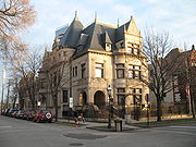
Historic structures
The area includes the Prairie Avenue Historic DistrictPrairie Avenue District
The Prairie Avenue District is a historic district in the Near South Side community area of Chicago, Illinois. It includes the 1800 and 1900 blocks of South Prairie Avenue and the 1800 block of South Indiana, and 211-217 East Cullerton. It was the site of the Battle of Fort Dearborn and became the...
(with both the John J. Glessner House
John J. Glessner House
The John J. Glessner House, operated as the Glessner House Museum, is an important 19th-century residence located at 1800 S. Prairie Avenue, Chicago, Illinois. It was designed in 1885-1886 by architect Henry Hobson Richardson and completed in late 1887. The property was designated a Chicago...
and the Henry B. Clarke House
Henry B. Clarke House
The Henry B. Clarke House is a Greek Revival style house in Chicago, Illinois, United States. The house was built in circa 1836 by a local contractor, probably John Rye, who later married the Clarkes' housemaid, Betsy. Clarke House may have been modeled on the home of William B. Ogden. The Clarke...
) and the historic (former) R. R. Donnelley & Sons printing company building (which now houses network routers and switches for much of the city). The Glessner House, which is perhaps the best known historic structure in this district, is now a museum. William Wallace Kimball's home is now home to the United States Soccer Federation
United States Soccer Federation
The United States Soccer Federation is the official governing body of the sport of soccer in the United States. Its headquarters are located in Chicago, Illinois. It is a member of FIFA and is responsible for governing amateur and professional soccer, including the men's, women's, youth, futsal...
headquarters. Formerly, several important residences were located in this region. Additionally, the Fort Dearborn Massacre sculpture was on the property of the George Pullman
George Pullman
George Mortimer Pullman was an American inventor and industrialist. He is known as the inventor of the Pullman sleeping car, and for violently suppressing striking workers in the company town he created, Pullman .-Background:Born in Brocton, New York, his family moved to Albion,...
residence as a tribute to the massacre, which occurred in the neighborhood. Most of the Prairie Avenue
Prairie Avenue
Prairie Avenue is a north–south thoroughfare on the South Side of Chicago, which historically extended from 16th Street in the Near South Side community area of Chicago in Cook County, Illinois, United States, to the city's southern limits and beyond. The street has a rich history from its origins...
families worshiped at the Second Presbyterian Church of Chicago
Second Presbyterian Church of Chicago
Second Presbyterian Church is a landmark Gothic Revival church located on South Michigan Avenue in Chicago, Illinois, United States. In the late nineteenth and early twentieth centuries, some of Chicago’s most prominent families attended this church. It is renowned for its interior, completely...
.
Adler Planetarium
Adler Planetarium
The Adler Planetarium & Astronomy Museum in Chicago, Illinois was the first planetarium built in the Western Hemisphere and is the oldest in existence today. Adler was founded and built in 1930 by the philanthropist Max Adler, with the assistance of the first director of the planetarium, Philip Fox...
, R.R. Donnelley and Sons Co. Calumet Plant
R.R. Donnelley and Sons Co. Calumet Plant
The R.R Donnelley Printing Plant, sometimes known as the Lakeside Press Building or more simply The Calumet Plant and now known as the Lakeside Technology Center, was built between 1912 and 1929 to house the operations of the RR Donnelley printing company...
, Henry B. Clarke House
Henry B. Clarke House
The Henry B. Clarke House is a Greek Revival style house in Chicago, Illinois, United States. The house was built in circa 1836 by a local contractor, probably John Rye, who later married the Clarkes' housemaid, Betsy. Clarke House may have been modeled on the home of William B. Ogden. The Clarke...
, Coca Cola Company Building (on Wabash), Field Museum of Natural History
Field Museum of Natural History
The Field Museum of Natural History is located in Chicago, Illinois, USA. It sits on Lake Shore Drive next to Lake Michigan, part of a scenic complex known as the Museum Campus Chicago...
, John J. Glessner House
John J. Glessner House
The John J. Glessner House, operated as the Glessner House Museum, is an important 19th-century residence located at 1800 S. Prairie Avenue, Chicago, Illinois. It was designed in 1885-1886 by architect Henry Hobson Richardson and completed in late 1887. The property was designated a Chicago...
, William W. Kimball House, Maxwell-Briscoe Automobile Company Showroom, Quinn Chapel AME Church
Quinn Chapel AME Church (Chicago, Illinois)
Quinn Chapel AME Church, also known as Quinn Chapel of the A.M.E. Church, houses Chicago's oldest African-American congregation, formed by seven individuals as a nondenominational prayer group that met in the house of a member in 1844. In 1847, the group organized as a congregation of the African...
, Harriet F. Rees House, Reid House, St. Luke's Hospital Complex, Second Presbyterian Church, Shedd Aquarium
Shedd Aquarium
The John G. Shedd Aquarium is an indoor public aquarium in Chicago, Illinois in the United States that opened on May 30, 1930. The aquarium contains over 25,000 fish, and was for some time the largest indoor aquarium in the world with of water. The Shedd Aquarium was the first inland aquarium with...
, Soldier Field
Soldier Field
Soldier Field is located on Lake Shore Drive in Chicago, Illinois, United States, in the Near South Side. It is home to the NFL's Chicago Bears...
, and Wheeler-Kohn House
Wheeler-Kohn House
The Wheeler-Kohn House is a Queen Anne and Second Empire Style house in the Near South Side neighborhood of Chicago, Illinois, United States. The house was built in 1870 by Otis L. Wheelock for Calvin Wheeler....
are all located in the community area and are all listed on the National Register of Historic Places
National Register of Historic Places
The National Register of Historic Places is the United States government's official list of districts, sites, buildings, structures, and objects deemed worthy of preservation...
(NRHP). Raymond M. Hilliard Center Historic District, Motor Row District
Motor Row District
The Motor Row District is a historic district in Chicago’s Near South Side community area. Motor Row includes buildings on Michigan Avenue between 2200 and 2500 south, directly west of McCormick Place convention center, and 1444, 1454, 1737, 1925, 2000 S. Michigan Ave., as well as 2246-3453 S....
, and Prairie Avenue District
Prairie Avenue District
The Prairie Avenue District is a historic district in the Near South Side community area of Chicago, Illinois. It includes the 1800 and 1900 blocks of South Prairie Avenue and the 1800 block of South Indiana, and 211-217 East Cullerton. It was the site of the Battle of Fort Dearborn and became the...
are districts largely within the community area that are also listed on the NRHP.
Redevelopment
Central Station (Chicago neighborhood)
Currently, Central Station refers to a neighborhood within the Near South Side, Chicago community area in Chicago, Illinois, USA. Once , and later , the City of Chicago planned development is now . It encompasses the former rail yards and air space rights east of Indiana Avenue between Roosevelt...
is the site of major mixed use development that includes One Museum Park
One Museum Park
One Museum Park is a skyscraper in Chicago, USA. It was designed by Chicago-based architecture firm Pappageorge Haymes, Ltd. and is located in the Near South Side community area.-Overview:...
, One Museum Park West
One Museum Park West
One Museum Park West is the companion structure to One Museum Park in the Near South Side community area in Chicago, Illinois, USA...
, numerous residential condominiums and luxury townhomes. This development is built on 72 acres (291,373.9 m²) of former rail yards and air space rights east of Indiana Avenue between Roosevelt Road and 18th Street that include the former location of the Central Station terminal. Also, a wave of loft conversions in Printer's Row that has spread to major North-South Avenues such as Michigan, Wabash, and Indiana is making them residential streets again in this neighborhood after a century of other uses. The planned development has expanded from 69 to 80 acres (323,748.8 m²) and includes properties between Michigan and Indiana Avenues. In 2006, the Prairie District Neighborhood Alliance
Prairie District Neighborhood Alliance
The Prairie District Neighborhood Alliance is a non-profit resident organization in the South Loop community of Chicago, Illinois. The PDNA, founded in 2006, has grown to provide support and representation to thousands of residents living in and around the Prairie Avenue Historic District,...
, a non-profit organization was formed to provide representation for thousands of South Loop residents, including the Prairie District, Central Station and Museum Park, Motor Row, the South Michigan Ave Corridor, as well as other areas of the Near South Side.
Streets
Lake Shore DriveLake Shore Drive
Lake Shore Drive is a mostly freeway-standard expressway running parallel with and alongside the shoreline of Lake Michigan through Chicago, Illinois, USA. Except for the portion north of Foster Avenue , Lake Shore Drive is designated as part of U.S...
was reconstructed in 1996 so that it no longer cut through the Museum Campus. Previously the northbound lane ran east of Soldier Field. After reconstruction both lanes ran west of Soldier Field.
Its northern boundary (Roosevelt Road) marks the end of consecutively named east-west streets. East-west streets north of Roosevelt Road have street names except between State Street
State Street (Chicago)
State Street is a large south-north street in Chicago, Illinois, USA and its south suburbs. It begins on the Near North Side at North Avenue. For much of its course, it lies between Wabash Avenue on the east and Dearborn Street/Lafayette Avenue on the west...
and Michigan Avenue
Michigan Avenue (Chicago)
Michigan Avenue is a major north-south street in Chicago which runs at 100 east south of the Chicago River and at 132 East north of the river from 12628 south to 950 north in the Chicago street address system...
. There are two block-long 8th and 11th Streets and a four-block 9th Street. Most streets south of Roosevelt simply use street numbers. Streets in this neighborhood from 13th to 26th are mostly numbered. Cullerton St (20th Street) & Cermak Road (22nd Street) are two of the few named east-west cross streets. Numbering continues southward in Chicago into the upper hundreds at a pace of 8 blocks per mile.
South Loop/Printer's Row overlap
Prairie District Neighborhood Alliance
The Prairie District Neighborhood Alliance is a non-profit resident organization in the South Loop community of Chicago, Illinois. The PDNA, founded in 2006, has grown to provide support and representation to thousands of residents living in and around the Prairie Avenue Historic District,...
, a not-for-profit neighborhood organization, has grown to provide support and representation to thousands of residents living in and around the South Loop and Near South Side of Chicago, including the Prairie Avenue District, Central Station and Museum Park, Motor Row and the South Michigan Avenue corridor, but the organization does not exclude those that are part of the broader South Loop and Near South Side community. The Greater South Loop Association represents residents living between Congress to the North, the Chicago River
Chicago River
The Chicago River is a system of rivers and canals with a combined length of that runs through the city of the same name, including its center . Though not especially long, the river is notable for being the reason why Chicago became an important location, as the link between the Great Lakes and...
to the west and the Stevenson Expressway (approximately 25th Street) to the south. South Loop Neighbors serves residents only as far South as "approximately" 15th Street and as far west as the river. Fodor's
Fodor's
Fodor's is the world's largest publisher of English language travel and tourism information, and the first relatively professional producer of travel guidebooks...
has its own definition of the South Loop as the area bounded by Cermak, Michigan Avenue
Michigan Avenue (Chicago)
Michigan Avenue is a major north-south street in Chicago which runs at 100 east south of the Chicago River and at 132 East north of the river from 12628 south to 950 north in the Chicago street address system...
, the Chicago River
Chicago River
The Chicago River is a system of rivers and canals with a combined length of that runs through the city of the same name, including its center . Though not especially long, the river is notable for being the reason why Chicago became an important location, as the link between the Great Lakes and...
, and Congress Parkway-Eisenhower Expressway. The South Loop is described as the neighborhood immediately south of "the Loop", yet "the Loop" has multiple meanings. The Loop
Chicago Loop
The Loop or Chicago Loop is one of 77 officially designated Chicago community areas located in the City of Chicago, Illinois. It is the historic commercial center of downtown Chicago...
is a community area bounded by the Chicago River
Chicago River
The Chicago River is a system of rivers and canals with a combined length of that runs through the city of the same name, including its center . Though not especially long, the river is notable for being the reason why Chicago became an important location, as the link between the Great Lakes and...
, Lake Michigan
Lake Michigan
Lake Michigan is one of the five Great Lakes of North America and the only one located entirely within the United States. It is the second largest of the Great Lakes by volume and the third largest by surface area, after Lake Superior and Lake Huron...
and Roosevelt Road. However, the term is also used to refer to the specific area bounded by the circular portion of the Chicago Transit Authority
Chicago Transit Authority
Chicago Transit Authority, also known as CTA, is the operator of mass transit within the City of Chicago, Illinois and some of its surrounding suburbs....
's L Train
Chicago 'L'
The L is the rapid transit system serving the city of Chicago and some of its surrounding suburbs. It is operated by the Chicago Transit Authority...
, which goes as far south as Van Buren Street or Congress Avenue (and this is described as the northern border of Printer's Row and the South Loop). Some primary sources cite Printer's Row and the South Loop as part of the Near South Side community area
Community areas of Chicago
Community areas in Chicago refers to the work of the Social Science Research Committee at University of Chicago which has unofficially divided the City of Chicago into 77 community areas. These areas are well-defined and static...
. This transit-related area is the northern portion of the community area. Saying it is south of the former places it in the Near South Side, while saying it is part of the latter places it in the Loop. The Official City of Chicago Loop Map supports the latter.
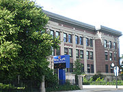
Education
Chicago Public Schools
Chicago Public Schools, commonly abbreviated as CPS by local residents and politicians and officially classified as City of Chicago School District #299 for funding and districting reasons, is a large school district that manages over 600 public elementary and high schools in Chicago, Illinois...
. K-8 schools serving sections of the Near South Side include Drake School, National Teacher Academy, and South Loop School. Phillips Academy High School is the zoned high school of the Near South Side.