Nedlands, Western Australia
Encyclopedia
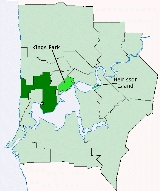
The City of Nedlands is a Local Government Area
in the inner western suburbs of the Western Australia
n capital city of Perth
, located about 7 kilometres (4 mi) west of Perth's central business district
. The City covers an area of 20 square kilometres (7.7 sq mi), maintains 137 km of roads and a little over 380 hectares (939 acre) of parks and gardens, and has a population of over 22,000 (2008).
, which had grown substantially in population at the end of the 19th century. Seven men were nominated to the new Board, which became the first local government authority for the Nedlands/Claremont area. In 1898, Claremont itself split away to form a municipal government, which still exists today as the Town of Claremont
.
In 1932, the Claremont Road Board was renamed Nedlands, and on 1 July 1959, it became a City. The City was made up of four wards – Melvista, Hollywood, Dalkeith and Coastal. These wards continue to the present day.
* Shared with other council areas (Subiaco; Cambridge)
Local Government Areas of Western Australia
The Australian state of Western Australia is divided into 141 local government areas...
in the inner western suburbs of the Western Australia
Western Australia
Western Australia is a state of Australia, occupying the entire western third of the Australian continent. It is bounded by the Indian Ocean to the north and west, the Great Australian Bight and Indian Ocean to the south, the Northern Territory to the north-east and South Australia to the south-east...
n capital city of Perth
Perth, Western Australia
Perth is the capital and largest city of the Australian state of Western Australia and the fourth most populous city in Australia. The Perth metropolitan area has an estimated population of almost 1,700,000....
, located about 7 kilometres (4 mi) west of Perth's central business district
Central business district
A central business district is the commercial and often geographic heart of a city. In North America this part of a city is commonly referred to as "downtown" or "city center"...
. The City covers an area of 20 square kilometres (7.7 sq mi), maintains 137 km of roads and a little over 380 hectares (939 acre) of parks and gardens, and has a population of over 22,000 (2008).
History
The City of Nedlands had its origins in the Claremont Road District, which was created in 1893 after a petition from ratepayers who lived in the areas of Nedlands and ClaremontClaremont, Western Australia
Claremont is a western suburb of Perth, Western Australia on the north bank of the Swan River.-History:Prior to European settlement, the Noongar people used the area as a source of water, for fishing and for catching waterfowl. In 1830, John Butler, a settler, set up an inn at Freshwater Bay to...
, which had grown substantially in population at the end of the 19th century. Seven men were nominated to the new Board, which became the first local government authority for the Nedlands/Claremont area. In 1898, Claremont itself split away to form a municipal government, which still exists today as the Town of Claremont
Town of Claremont
The Town of Claremont is a Local Government Area in the inner western suburbs of the Western Australian capital city of Perth, located about halfway between the port city of Fremantle and Perth's central business district...
.
In 1932, the Claremont Road Board was renamed Nedlands, and on 1 July 1959, it became a City. The City was made up of four wards – Melvista, Hollywood, Dalkeith and Coastal. These wards continue to the present day.
Wards
The town has been divided into 4 wards, each of 3 councillors. The mayor is directly elected.- Coastal Ward
- Dalkeith Ward
- Hollywood Ward
- Melvista Ward
Suburbs
- DalkeithDalkeith, Western AustraliaDalkeith is a suburb of Perth, Western Australia, located within the City of Nedlands. The suburb is surrounded on three sides by the Swan River and is home to some of Perth's finest mansions. The suburb takes its name from a cottage built in 1833 by Captain Adam Armstrong and his sons, early...
- FloreatFloreat, Western AustraliaFloreat is a residential suburb located west-northwest from the central business district of Perth, the capital of Western Australia. It is bordered on three sides by Underwood Avenue, Selby Street, and Cromarty Road; the western border adjoins or runs through Bold Park. It is located in the Town...
* - KarrakattaKarrakatta, Western AustraliaKarrakatta is a suburb of Perth, Western Australia, located within the City of Nedlands and 7 km west of the CBD. Its postcode is 6010. Karrakatta is composed of two distinct areas. The largest is Karrakatta Cemetery, which began service in 1899, with a small industrial area on the south...
- Mount ClaremontMount Claremont, Western AustraliaMount Claremont is a suburb of Perth, Western Australia, Australia, located within the Town of Cambridge and the City of Nedlands. It consists mostly of residential estates which were built in the late 1980s and early 1990s...
- NedlandsNedlands, Western AustraliaThe City of Nedlands is a Local Government Area in the inner western suburbs of the Western Australian capital city of Perth, located about west of Perth's central business district...
* - Shenton ParkShenton Park, Western AustraliaShenton Park is a suburb of Perth, Western Australia, located within the City of Subiaco and 4 km west of the Central business district. Its postcode is 6008...
*
Population
| Year | Population |
|---|---|
| 1911 | 1,230 |
| 1921 | 3,557 |
| 1933 | 10,580 |
| 1947 | 18,226 |
| 1954 | 22,814 |
| 1961 | 23,218 |
| 1966 | 23,320 |
| 1971 | 22,878 |
| 1976 | 20,974 |
| 1981 | 20,257 |
| 1986 | 18,623 |
| 1991 | 20,210 |
| 1996 | 20,598 |
| 2001 | 21,047 |
| 2006 | 20,334 |

