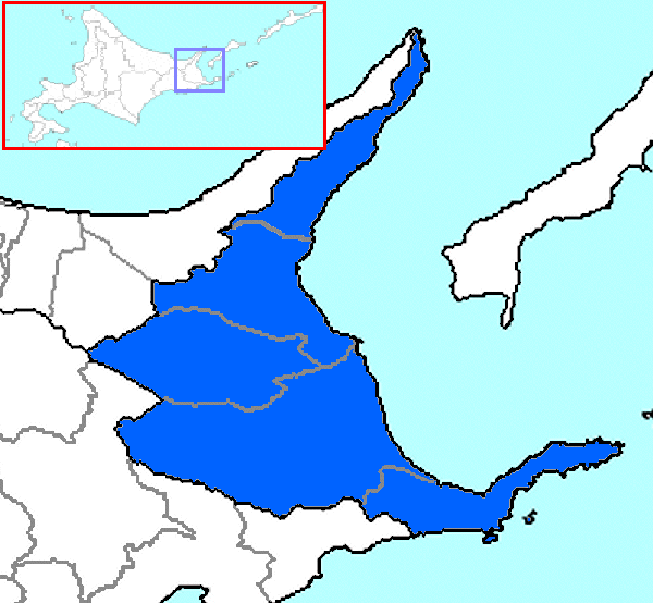
Nemuro Subprefecture
Encyclopedia
is a subprefecture
of Hokkaidō
, Japan
. The Japanese claim the disputed Southern Kurile Islands (known as the Northern Territories in Japan) as part of this subprefecture.
As of July 31, 2004, the subprefecture has an estimated population of 86,152 and a (claimed) area of 8533.96 km².
Nakashibetsu Airport, the easternmost airport in Japan, is located in the Town of Nakashibetsu
, Shibetsu District
.

.gif)
43.33038°N 145.584389°W
Subprefectures in Hokkaido
Hokkaido Prefecture had 14 branch offices called 支庁 in Japanese, which is often translated in English as subprefectures. Normally, a subprefecture consists of a few to a dozen cities, towns, and/or villages....
of Hokkaidō
Hokkaido
, formerly known as Ezo, Yezo, Yeso, or Yesso, is Japan's second largest island; it is also the largest and northernmost of Japan's 47 prefectural-level subdivisions. The Tsugaru Strait separates Hokkaido from Honshu, although the two islands are connected by the underwater railway Seikan Tunnel...
, Japan
Japan
Japan is an island nation in East Asia. Located in the Pacific Ocean, it lies to the east of the Sea of Japan, China, North Korea, South Korea and Russia, stretching from the Sea of Okhotsk in the north to the East China Sea and Taiwan in the south...
. The Japanese claim the disputed Southern Kurile Islands (known as the Northern Territories in Japan) as part of this subprefecture.
As of July 31, 2004, the subprefecture has an estimated population of 86,152 and a (claimed) area of 8533.96 km².
Nakashibetsu Airport, the easternmost airport in Japan, is located in the Town of Nakashibetsu
Nakashibetsu, Hokkaido
is a town located in Shibetsu District, Nemuro Subprefecture, Hokkaidō Prefecture. As of March 31, 2008 it has an estimated population of 23,958 and an area of 684.98 km².Nakashibetsu Airport, the easternmost airport in Japan, is located in the town.- History :...
, Shibetsu District
Shibetsu District, Hokkaido
is a district located in Nemuro Subprefecture, Hokkaidō, Japan. As of 2004, its estimated population is 30,285 with a total area of 1309.44 km²Nakashibetsu Airport, the easternmost airport in Japan, is located in Nakashibetsu.-History:...
.
History
- November, 1897 Nemuro Subprefecture established
- November, 1897 Shana Subprefecture established
- December, 1903 Shana Subprefecture and Nemuro Subprefecture merged
- August, 1945 SovietsSoviet UnionThe Soviet Union , officially the Union of Soviet Socialist Republics , was a constitutionally socialist state that existed in Eurasia between 1922 and 1991....
occupy the Kuril Islands
Geography

Towns and villages by district
- Menashi DistrictMenashi District, Hokkaidois a district located in Nemuro Subprefecture, Hokkaidō, Japan. As of 2010, its population is estimated at 6,069 and its area is 397.88 km², with a population density of 15.3/km2 The origin of the name “Menashi” comes from the Ainu word menashi, meaning “to the east.” The local government...
- RausuRausu, Hokkaidois a town located in Menashi District, Nemuro Subprefecture, Hokkaidō. As of March 31, 2008 it has an estimated population of 6,202 and an area of 397.88 km²....
- Rausu
- Notsuke DistrictNotsuke District, Hokkaidois a district in Nemuro Subprefecture, Hokkaidō, Japan. As of 2004, it has an estimated population of 17,010 and an area of 1,320.15 km².-History:*1869 Hokkaidō divided into 11 provinces and 86 districts, Notsuke district placed in Nemuro Province...
- BetsukaiBetsukai, Hokkaidois a town located in Notsuke District, Nemuro Subprefecture, Hokkaidō Prefecture. As of March 31, 2008 it has an estimated population of 16,335 and an area of 1,320.15 km² . The town is primarily agricultural, with numerous cow farms...
- Betsukai
- Shibetsu DistrictShibetsu District, Hokkaidois a district located in Nemuro Subprefecture, Hokkaidō, Japan. As of 2004, its estimated population is 30,285 with a total area of 1309.44 km²Nakashibetsu Airport, the easternmost airport in Japan, is located in Nakashibetsu.-History:...
- NakashibetsuNakashibetsu, Hokkaidois a town located in Shibetsu District, Nemuro Subprefecture, Hokkaidō Prefecture. As of March 31, 2008 it has an estimated population of 23,958 and an area of 684.98 km².Nakashibetsu Airport, the easternmost airport in Japan, is located in the town.- History :...
- ShibetsuShibetsu, Hokkaido (Nemuro)is a town located in Shibetsu District, Nemuro Subprefecture, Hokkaidō, Japan. As of April 1, 2009 it has an estimated population of 5,825 and an area of 624.49 km²....
- Nakashibetsu
Districts in the Northern Territories
- Also knonwn as the Southern Kurile Islands (occupied and administered by RussiaRussiaRussia or , officially known as both Russia and the Russian Federation , is a country in northern Eurasia. It is a federal semi-presidential republic, comprising 83 federal subjects...
, claimed by Japan)- ShikotanShikotan District, Hokkaidois a district that is part of Nemuro Subprefecture, Hokkaidō, Japan. It covers Shikotan Island, which is claimed by Japan and Russia. As of August 15, 1945, it had a population of 1,038.-History:*1885 Split off Hanasaki District, Nemuro Province...
- Shikotan
- Kunashiri (Kunashir)
- Tomari (Golovnino)
- Ruyobetsu (Yuzhno Kurilsk)
- Etorofu (IturupIturupIturup is the largest island of the South Kuril Islands. It is the northernmost island in the southern Kuril/Chishima islands, and though it is presently controlled by Russia, Japan also claims this island...
)- Rubetsu (Pioner)
- Shana
- Shana (Kurilsk)
- ShibetoroShibetoro District, HokkaidoIn Japanese, refers to a region disputed between Russia and Japan, currently under Russian administration. Under Japanese classification, it belongs to Nemuro Subprefecture, Hokkaidō, Japan...
- Shibetoro (Rudnaya)
- Shikotan
Districts renounced in San Francisco Treaty
- Uruppu
- Shimushiro (Shimushir)
- Shumushu
Islands
.gif)
- Habomai Rocks
- ShikotanShikotanShikotan, in Russian , Japanese , or シコタㇴ), is one of the bigger islands of the Kuril Islands, which are controlled by Russia. It is one of the four southernmost islands which Japan maintains a claim for...
Island - Kunashiri
- EtorofuEtorofuEtorofu was an escort ship of the Imperial Japanese Navy during World War II....
(IturupIturupIturup is the largest island of the South Kuril Islands. It is the northernmost island in the southern Kuril/Chishima islands, and though it is presently controlled by Russia, Japan also claims this island...
)
External links
Official website43.33038°N 145.584389°W

