
New Holland, Pennsylvania
Encyclopedia
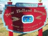
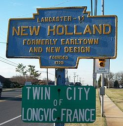
New Holland is a borough in Lancaster County
in Pennsylvania
, USA
. The population was 5,092 at the 2000 census. New Holland was settled in 1728 by John Michael and John Phillip Ranc (Ranck). Before it became known as New Holland, it had been called Hog Swamp, Earltown and New Design. New Holland, Pennsylvania is the twin city
of Longvic
, France
.
, the borough has a total area of 2.1 square miles (5.4 km²), all of it land.
of 2000, there were 5,092 people, 2,084 households, and 1,448 families residing in the borough. The population density
was 2,444.2 people per square mile (945.2/km²). There were 2,159 housing units at an average density of 1,036.3 per square mile (400.8/km²). The racial makeup of the borough was 90.34% White, 1.02% African American, 0.08% Native American, .025% Asian, 0.02% Pacific Islander, 2.57% from other races
, and 1.67% from two or more races. Hispanic or Latino of any race were 6.42% of the population.
In the borough the population was spread out with 22.4% under the age of 18, 8.1% from 18 to 24, 28.6% from 25 to 44, 24.9% from 45 to 64, and 16.1% who were 65 years of age or older. The median age was 40 years. For every 100 females there were 95.3 males. For every 100 females age 18 and over, there were 94.1 males.
The median income for a household in the borough was $44,446, and the median income for a family was $50,758. Males had a median income of $37,002 versus $25,766 for females. The per capita income
for the borough was $20,187. About 3.4% of families and 5.2% of the population were below the poverty line, including 7.5% of those under age 18 and 1.5% of those age 65 or over.
has its district headquarters in New Holland, Pennsylvania. This site also houses both Garden Spot High School
and Garden Spot Middle School
. Elementary schools within the district include: New Holland, Blue Ball
and Brecknock.
Lancaster County, Pennsylvania
Lancaster County, known as the Garden Spot of America or Pennsylvania Dutch Country, is a county located in the southeastern part of the Commonwealth of Pennsylvania, in the United States. As of 2010 the population was 519,445. Lancaster County forms the Lancaster Metropolitan Statistical Area, the...
in Pennsylvania
Pennsylvania
The Commonwealth of Pennsylvania is a U.S. state that is located in the Northeastern and Mid-Atlantic regions of the United States. The state borders Delaware and Maryland to the south, West Virginia to the southwest, Ohio to the west, New York and Ontario, Canada, to the north, and New Jersey to...
, USA
United States
The United States of America is a federal constitutional republic comprising fifty states and a federal district...
. The population was 5,092 at the 2000 census. New Holland was settled in 1728 by John Michael and John Phillip Ranc (Ranck). Before it became known as New Holland, it had been called Hog Swamp, Earltown and New Design. New Holland, Pennsylvania is the twin city
Town twinning
Twin towns and sister cities are two of many terms used to describe the cooperative agreements between towns, cities, and even counties in geographically and politically distinct areas to promote cultural and commercial ties.- Terminology :...
of Longvic
Longvic
Longvic is a commune in the Côte-d'Or department in eastern France.-Population:-References:*...
, France
France
The French Republic , The French Republic , The French Republic , (commonly known as France , is a unitary semi-presidential republic in Western Europe with several overseas territories and islands located on other continents and in the Indian, Pacific, and Atlantic oceans. Metropolitan France...
.
Geography
New Holland is located at 40°6′8"N 76°5′16"W (40.102095, -76.087646). According to the United States Census BureauUnited States Census Bureau
The United States Census Bureau is the government agency that is responsible for the United States Census. It also gathers other national demographic and economic data...
, the borough has a total area of 2.1 square miles (5.4 km²), all of it land.
Demographics
As of the censusCensus
A census is the procedure of systematically acquiring and recording information about the members of a given population. It is a regularly occurring and official count of a particular population. The term is used mostly in connection with national population and housing censuses; other common...
of 2000, there were 5,092 people, 2,084 households, and 1,448 families residing in the borough. The population density
Population density
Population density is a measurement of population per unit area or unit volume. It is frequently applied to living organisms, and particularly to humans...
was 2,444.2 people per square mile (945.2/km²). There were 2,159 housing units at an average density of 1,036.3 per square mile (400.8/km²). The racial makeup of the borough was 90.34% White, 1.02% African American, 0.08% Native American, .025% Asian, 0.02% Pacific Islander, 2.57% from other races
Race (United States Census)
Race and ethnicity in the United States Census, as defined by the Federal Office of Management and Budget and the United States Census Bureau, are self-identification data items in which residents choose the race or races with which they most closely identify, and indicate whether or not they are...
, and 1.67% from two or more races. Hispanic or Latino of any race were 6.42% of the population.
In the borough the population was spread out with 22.4% under the age of 18, 8.1% from 18 to 24, 28.6% from 25 to 44, 24.9% from 45 to 64, and 16.1% who were 65 years of age or older. The median age was 40 years. For every 100 females there were 95.3 males. For every 100 females age 18 and over, there were 94.1 males.
The median income for a household in the borough was $44,446, and the median income for a family was $50,758. Males had a median income of $37,002 versus $25,766 for females. The per capita income
Per capita income
Per capita income or income per person is a measure of mean income within an economic aggregate, such as a country or city. It is calculated by taking a measure of all sources of income in the aggregate and dividing it by the total population...
for the borough was $20,187. About 3.4% of families and 5.2% of the population were below the poverty line, including 7.5% of those under age 18 and 1.5% of those age 65 or over.
Education
The Eastern Lancaster County School DistrictEastern Lancaster County School District
The Eastern Lancaster County School District is a school district in Lancaster County, Pennsylvania. It is a member of Lancaster–Lebanon Intermediate Unit 13.-Schools:* Brecknock Elementary School – Denver, Pennsylvania...
has its district headquarters in New Holland, Pennsylvania. This site also houses both Garden Spot High School
Garden Spot High School
Garden Spot High School is located in New Holland, Lancaster County, Pennsylvania. Founded in the 1950s, this is the only Senior High School in the Eastern Lancaster County School District.-Garden Spot Performing Arts:...
and Garden Spot Middle School
Garden Spot Middle School
Garden Spot Middle School is located in New Holland, Lancaster County, Pennsylvania. This is the only junior high school in the Eastern Lancaster County School District.-External links:*-References:...
. Elementary schools within the district include: New Holland, Blue Ball
Blue Ball, Pennsylvania
Blue Ball is an unincorporated community in Lancaster County, Pennsylvania near 40°N 76°W. Blue Ball lies approximately 2 miles east-northeast of the town of New Holland, Pennsylvania at the intersection of US 322 and PA Route 23.-Name and origin:...
and Brecknock.
External links