
New York State Route 100
Encyclopedia
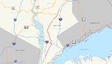
New York State Route 100 (NY 100) is a major north–south state highway in Westchester County, New York
, in the United States. It begins parallel to Interstate 87 (I-87) at a junction with the Cross County Parkway
in the city of Yonkers
and runs through most of the length of the county via the city of White Plains
up to U.S. Route 202
(US 202) in the town of Somers
just south of the county line with Putnam County
. NY 100 was designated as part of the 1930 renumbering of state highways in New York. Prior to becoming a state road, various sections of NY 100 were part of several important early roads in the county.
 The highway begins in Yonkers
city as Central Park Avenue at exit 4 of the New York State Thruway
(I-87). This portion of Central Park Avenue is maintained by Westchester County as the unsigned
County Route 47II (CR 47II). Central Park Avenue continues south into the Bronx and serves as a frontage road for I-87 in this area. NY 100 diverges from I-87 just north of exit 5 and heads northeast, crossing over the Sprain Brook Parkway
about 0.6 mile (0.965604 km) beyond the split. Central Park Avenue continues out of the city of Yonkers in the area between the Grassy Sprain Reservoir
and the Bronx River
into the town of Greenburgh
. NY 100 runs through the hamlet of Hartsdale
, about two miles (3 km) north of the city line, and where the loop route NY 100A (Hartsdale Avenue) begins. Central Park Avenue then enters the city limits of White Plains
, where the road ends at NY 119 (Tarrytown Road). Within White Plains, the road is county-maintained with unsigned designations of CR 99 and CR 90.
NY 100 north follows NY 119 west for a 0.5 mile (0.80467 km) overlap through the town center of Greenburgh
. Access to I-287 and the Bronx River Parkway
can be made in the vicinity of the 100/119 overlap. NY 100 then splits off to the north using Hillside Avenue and Grasslands Road as it goes around the perimeter of Westchester Community College
. At a four-way intersection between Grasslands Road, Knollwood Road, and Bradhurst Avenue, NY 100 meets with the north end of NY 100A (Knollwood Road) and the east end of NY 100C (Grasslands Road). To continue on NY 100, one must turn north onto Bradhurst Avenue. Bradhurst Avenue leads into the hamlet of Hawthorne
within the town of Mount Pleasant
, crossing over the Sprain Brook Parkway
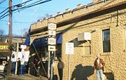
along the way. NY 100 then shifts onto Saw Mill River Road (NY 9A) using a brief section of NY 141 (Broadway). From this junction, Saw Mill River Road (carrying 9A and 100) is a partially controlled-access highway as it continues north alongside the Taconic State Parkway
. It has a grade-separated junction with NY 117 (Bedford Road) about 1.1 miles (1.8 km) north of the 9A/100 merge. 9A and 100 then enter the eastern edge of the village of Briarcliff Manor
.
 NY 100 then branches off on its own again in Briarcliff Manor, with NY 9A continuing north along the Briarcliff–Peekskill Parkway and NY 100 continuing northeast on the Saw Mill River Road, which roughly follows New York Central's old Putnam Division railroad. Many of the railroad's old stations can still be found along the highway. NY 100 passes through New Castle
and meets NY 133 in the hamlet of Millwood
, where access to the Taconic State Parkway
can also be made. From here, NY 100 then follows the path of the Croton Turnpike (alternatively known in the area as Somerstown Turnpike and also as Saw Mill River Road). The road continues into the town of Yorktown
, passing by the hamlet of Kitchawan. NY 100 then crosses the Croton Reservoir
on Pines Bridge. After crossing the reservoir, NY 118 splits off to the west on Saw Mill River Road, while NY 100 continues northeast on the Croton Turnpike.
 The Croton Turnpike continues into the town of Somers
, passing by some of the last remaining rural areas in Westchester County, including Muscoot Farm
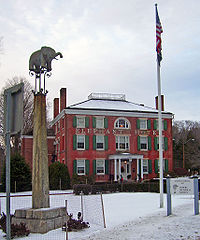
, a county owned early-1900's interpretive farm. North of the farm NY 100 intersects with NY 35 in the hamlet of Whitehall Corners, where a Pepsi Cola plant is located. In its northern extremes, NY 100 roughly parallels the Croton Reservoir on the north side before meeting up with US 202
in the hamlet of Somers
, where it ends opposite the Elephant Hotel
.
in 1874 connecting Macombs Dam Bridge
(then known as Central Bridge) to Westchester County. The road continues south into the Bronx as Jerome Avenue
, which was originally also called Central Park Avenue.
The middle section of NY 100 uses the Saw Mill River Road, an early colonial road connecting many different hamlets and villages in Westchester County. It follows along the path of various rivers and brooks as it winds its way to the north of the county. The road is now used as parts of several state routes, including NY 9A
, NY 100, and NY 118
. The section used by NY 100 follows the path of the Pocantico River between the hamlets of Hawthorne
and Millwood
.
The northernmost section of NY 100 runs along a part of the "Croton Turnpike", an early private toll road that was chartered in 1807. The Croton Turnpike connects the village of Ossining
(then called Sing Sing) to the hamlet of Somers
via Kitchawan. The road was made free in 1849. The Saw Mill River Road was rerouted to overlap the Croton Turnpike as it navigates around and across the Croton Reservoir, which was constructed between 1837 and 1842.
In 1908, the New York State Legislature created Route 2, an unsigned legislative route
extending from the New York City
line at Yonkers
to the Columbia County
village of Valatie
. Route 2 followed Central Park Avenue (mostly now NY 100) north through Yonkers to Hartsdale
, where it veered west to bypass White Plains
on modern NY 100A
, NY 100B
, and NY 119
. It rejoined what is now NY 100 at the junction of Tarrytown Road (NY 119) and Hillside Avenue and followed it north along Hillside Avenue and Grasslands Road to the modern junction of NY 100, NY 100A, and NY 100C
, at which point Route 2 continued west toward the Hudson River
on current NY 100C.
(now NY 6N) in Mahopac Falls on what is now NY 118, Baldwin Place Road, and Myrtle Avenue. Also assigned at this time was NY 118, which began adjacent to the Croton Reservoir at NY 100 and proceeded northeast along the Croton Turnpike to NY 22
in Croton Falls via modern NY 100 and US 202
. Ca. 1939, the alignments of NY 100 and NY 118 north of the Croton Reservoir were swapped, placing NY 118 on the more westerly alignment and NY 100 on the Croton Turnpike between the reservoir and Croton Falls.
In December 1934, at the insistence of the Automobile Club of New York, several numbered routes were extended and signed within New York City
, with NY 100 being one of these routes. NY 100 was extended south from the Yonkers line in the Bronx along Jerome Avenue
to the Grand Concourse
. NY 100 crossed into Manhattan via East 149th Street and the 145th Street Bridge
. In Manhattan, NY 100 continued south along Lenox Avenue, 110th Street
, Fifth Avenue, 96th Street
, and Park Avenue
, ending at Houston Street (NY 1A). South of Fordham Road
, NY 100 was overlapped with NY 22 all the way to Houston Street. The NY 100 designation was removed from New York City
following the opening of the Major Deegan Expressway
in 1956.
In 1934, US 202 was designated and overlapped with NY 118 (later NY 100) from Somers
to Croton Falls. The overlap between NY 100 and US 202 lasted as late as 1990. NY 100 was cut back to end at US 202 in Somers by 2004. The south end of NY 100 had been at the New York City line since 1956; however, as of 2007, NYSDOT recognizes the Cross County Parkway
underpass as the official southern terminus of NY 100.
. This 21 miles (34 km) extension was stretch to Putnam County
. The area was a high-priority corridor, stretching from the Cross Westchester Expressway (I-287) to the proposed Northern Westchester Expressway (NY 35). North of NY 35, the area was a medium-priority corridor, ending at US 6
in Mahopac. This plan was not implemented.
|rowspan=2|
|rowspan=2|
|-
|rowspan=7|Mount Pleasant
Westchester County, New York
Westchester County is a county located in the U.S. state of New York. Westchester covers an area of and has a population of 949,113 according to the 2010 Census, residing in 45 municipalities...
, in the United States. It begins parallel to Interstate 87 (I-87) at a junction with the Cross County Parkway
Cross County Parkway
The Cross County Parkway is a long parkway in Westchester County, New York. The parkway is a critical east–west connection throughout Westchester, having full interchanges with every major north–south parkway in southern Westchester, in addition to the New York State Thruway mainline....
in the city of Yonkers
Yonkers, New York
Yonkers is the fourth most populous city in the state of New York , and the most populous city in Westchester County, with a population of 195,976...
and runs through most of the length of the county via the city of White Plains
White Plains, New York
White Plains is a city and the county seat of Westchester County, New York, United States. It is located in south-central Westchester, about east of the Hudson River and northwest of Long Island Sound...
up to U.S. Route 202
U.S. Route 202 in New York
U.S. Route 202 is a part of the U.S. Highway System that runs from New Castle, Delaware, to Bangor, Maine. In the U.S. state of New York, US 202 extends from the New Jersey state line near Suffern to the Connecticut state line east of Brewster. While most of US 202 is signed...
(US 202) in the town of Somers
Somers, New York
Somers is a town located in northeastern Westchester County, New York, United States. As of the 2010 census, the town had a population of 20,434...
just south of the county line with Putnam County
Putnam County, New York
Putnam County is a county located in the U.S. state of New York, in the lower Hudson River Valley. Putnam county formed in 1812, when it detached from Dutchess County. , the population was 99,710. It is part of the New York Metropolitan Area. The county seat is the hamlet of Carmel...
. NY 100 was designated as part of the 1930 renumbering of state highways in New York. Prior to becoming a state road, various sections of NY 100 were part of several important early roads in the county.
Route description
Yonkers, New York
Yonkers is the fourth most populous city in the state of New York , and the most populous city in Westchester County, with a population of 195,976...
city as Central Park Avenue at exit 4 of the New York State Thruway
New York State Thruway
The New York State Thruway is a system of limited-access highways located within the state of New York in the United States. The system, known officially as the Governor Thomas E. Dewey Thruway for former New York Governor Thomas E. Dewey, is operated by the New York State Thruway Authority and...
(I-87). This portion of Central Park Avenue is maintained by Westchester County as the unsigned
Unsigned highway
An unsigned highway is a highway that has been assigned a route number, but does not bear conventional road markings that would normally be used to identify the route with that number...
County Route 47II (CR 47II). Central Park Avenue continues south into the Bronx and serves as a frontage road for I-87 in this area. NY 100 diverges from I-87 just north of exit 5 and heads northeast, crossing over the Sprain Brook Parkway
Sprain Brook Parkway
The Sprain Brook Parkway is a long north–south parkway in Westchester County, New York. It is one of the newest and most modern parkways in Westchester County, adopting many ideas and improvements developed during decades of statewide highway construction. The southern terminus is at the...
about 0.6 mile (0.965604 km) beyond the split. Central Park Avenue continues out of the city of Yonkers in the area between the Grassy Sprain Reservoir
Grassy Sprain Reservoir
The Grassy Sprain Reservoir is a storage reservoir in northern Yonkers, New York. It was completed in 1876 by the city of Yonkers as the city's main storage reservoir. The reservoir was formed by the Grassy Sprain Brook Dam which impounded the Sprain Brook River and Grassy Sprain River...
and the Bronx River
Bronx River
The Bronx River, approximately long, flows through southeast New York in the United States. It is named after colonial settler Jonas Bronck. The Bronx River is the only fresh water river in New York City....
into the town of Greenburgh
Greenburgh, New York
Greenburgh is a town in the western part of Westchester County, New York, United States. The population was 88,400 at the 2010 census. Paul J. Feiner has been the Town Supervisor since 1991.-History:...
. NY 100 runs through the hamlet of Hartsdale
Hartsdale, New York
Hartsdale is a hamlet and a census-designated place located in the town of Greenburgh, Westchester County, New York. The population was 5,293 at the 2010 census.-Geography:Hartsdale is located at ....
, about two miles (3 km) north of the city line, and where the loop route NY 100A (Hartsdale Avenue) begins. Central Park Avenue then enters the city limits of White Plains
White Plains, New York
White Plains is a city and the county seat of Westchester County, New York, United States. It is located in south-central Westchester, about east of the Hudson River and northwest of Long Island Sound...
, where the road ends at NY 119 (Tarrytown Road). Within White Plains, the road is county-maintained with unsigned designations of CR 99 and CR 90.
NY 100 north follows NY 119 west for a 0.5 mile (0.80467 km) overlap through the town center of Greenburgh
Greenburgh, New York
Greenburgh is a town in the western part of Westchester County, New York, United States. The population was 88,400 at the 2010 census. Paul J. Feiner has been the Town Supervisor since 1991.-History:...
. Access to I-287 and the Bronx River Parkway
Bronx River Parkway
The Bronx River Parkway is a long parkway in downstate New York. It is named for the nearby Bronx River, which it parallels. The southern terminus of the parkway is at Story Avenue near Bruckner Expressway in the Bronx neighborhood of Soundview...
can be made in the vicinity of the 100/119 overlap. NY 100 then splits off to the north using Hillside Avenue and Grasslands Road as it goes around the perimeter of Westchester Community College
Westchester Community College
Westchester Community College is a public, two-year community college in Valhalla, New York, sponsored by Westchester County, New York, and the State University of New York . The college is one of 30 community colleges affiliated with SUNY....
. At a four-way intersection between Grasslands Road, Knollwood Road, and Bradhurst Avenue, NY 100 meets with the north end of NY 100A (Knollwood Road) and the east end of NY 100C (Grasslands Road). To continue on NY 100, one must turn north onto Bradhurst Avenue. Bradhurst Avenue leads into the hamlet of Hawthorne
Hawthorne, New York
Hawthorne is an unincorporated hamlet and census-designated place located in the town of Mount Pleasant in Westchester County, New York. The population was 4,586 at the 2010 census.-History:...
within the town of Mount Pleasant
Mount Pleasant, New York
Mount Pleasant is a town in Westchester County, New York, in the United States. As of the 2010 census, the town population was 43,724.-Geography:...
, crossing over the Sprain Brook Parkway
Sprain Brook Parkway
The Sprain Brook Parkway is a long north–south parkway in Westchester County, New York. It is one of the newest and most modern parkways in Westchester County, adopting many ideas and improvements developed during decades of statewide highway construction. The southern terminus is at the...
along the way. NY 100 then shifts onto Saw Mill River Road (NY 9A) using a brief section of NY 141 (Broadway). From this junction, Saw Mill River Road (carrying 9A and 100) is a partially controlled-access highway as it continues north alongside the Taconic State Parkway
Taconic State Parkway
The Taconic State Parkway , is a divided highway between Kensico Dam and Chatham, the longest parkway in the U.S. state of New York. It follows a generally northward route midway between the Hudson River and the Connecticut and Massachusetts state lines...
. It has a grade-separated junction with NY 117 (Bedford Road) about 1.1 miles (1.8 km) north of the 9A/100 merge. 9A and 100 then enter the eastern edge of the village of Briarcliff Manor
Briarcliff Manor, New York
Briarcliff Manor is a village in Westchester County in the state of New York. It is shared between the towns of Mount Pleasant and Ossining, and lies entirely within the ZIP code of 10510...
.
New Castle, New York
New Castle is a town in Westchester County, New York, United States. The population was 17,569 at the 2010 census.-Geography:According to the United States Census Bureau, the town has a total area of , of which is land and , or 1.15%, is water. New Castle is bordered by the towns of Mount Pleasant...
and meets NY 133 in the hamlet of Millwood
Millwood, New York
Millwood is a hamlet located in the town of New Castle, New York in Westchester County. It was originally settled as Sarlesville. The area now known as Millwood appears on 19th century maps as Merritt's Corners and Rockdale Mills...
, where access to the Taconic State Parkway
Taconic State Parkway
The Taconic State Parkway , is a divided highway between Kensico Dam and Chatham, the longest parkway in the U.S. state of New York. It follows a generally northward route midway between the Hudson River and the Connecticut and Massachusetts state lines...
can also be made. From here, NY 100 then follows the path of the Croton Turnpike (alternatively known in the area as Somerstown Turnpike and also as Saw Mill River Road). The road continues into the town of Yorktown
Yorktown, New York
Yorktown is a town in Westchester County, New York, in the suburbs of New York about north of midtown Manhattan. The town lies on the north border of Westchester County...
, passing by the hamlet of Kitchawan. NY 100 then crosses the Croton Reservoir
New Croton Reservoir
The New Croton reservoir is a narrow reservoir in Westchester County, New York, lying approximately north of New York City, for which the reservoir supplies water. It is the collecting point for water from all reservoirs in the Croton Watershed....
on Pines Bridge. After crossing the reservoir, NY 118 splits off to the west on Saw Mill River Road, while NY 100 continues northeast on the Croton Turnpike.
Somers, New York
Somers is a town located in northeastern Westchester County, New York, United States. As of the 2010 census, the town had a population of 20,434...
, passing by some of the last remaining rural areas in Westchester County, including Muscoot Farm
Muscoot Farm
Muscoot Farm is an early 20th century interpretative farm museum near Somers, New York in the United States. The farm is owned and operated by the Westchester County Department of Parks, Recreation and Conservation.-History:...
, a county owned early-1900's interpretive farm. North of the farm NY 100 intersects with NY 35 in the hamlet of Whitehall Corners, where a Pepsi Cola plant is located. In its northern extremes, NY 100 roughly parallels the Croton Reservoir on the north side before meeting up with US 202
U.S. Route 202 in New York
U.S. Route 202 is a part of the U.S. Highway System that runs from New Castle, Delaware, to Bangor, Maine. In the U.S. state of New York, US 202 extends from the New Jersey state line near Suffern to the Connecticut state line east of Brewster. While most of US 202 is signed...
in the hamlet of Somers
Somers, New York
Somers is a town located in northeastern Westchester County, New York, United States. As of the 2010 census, the town had a population of 20,434...
, where it ends opposite the Elephant Hotel
Elephant Hotel
You may be looking for the Coney Island elephant hotel, also known as Lucy the Elephant.The Elephant Hotel is a National Historic Landmark located in Somers, New York, a town in Westchester County, New York, USA. It was listed on the National Register of Historic Places in 1974 as Somers Town...
.
Early roads
The southernmost section of NY 100, known as "Central Park Avenue", appeared in maps by 1888. It was constructed as a plank roadPlank road
A plank road or puncheon is a dirt path or road covered with a series of planks, similar to the wooden sidewalks one would see in a Western movie. Plank roads were very popular in Ontario, the U.S. Northeast and U.S. Midwest in the first half of the 19th century...
in 1874 connecting Macombs Dam Bridge
Macombs Dam Bridge
Macombs Dam Bridge is a swing bridge that spans the Harlem River in New York City, connecting the boroughs of Manhattan and the Bronx near Yankee Stadium. It is the third-oldest bridge in New York City and was designated an official landmark in January 1992...
(then known as Central Bridge) to Westchester County. The road continues south into the Bronx as Jerome Avenue
Jerome Avenue
Jerome Avenue is one of the longest thoroughfares in the New York City borough of the Bronx, New York, United States. The road is 5.6 miles long and stretches from Highbridge general area to Woodlawn. Both of these termini are with the Major Deegan Expressway which runs parallel to the west. Most...
, which was originally also called Central Park Avenue.
The middle section of NY 100 uses the Saw Mill River Road, an early colonial road connecting many different hamlets and villages in Westchester County. It follows along the path of various rivers and brooks as it winds its way to the north of the county. The road is now used as parts of several state routes, including NY 9A
New York State Route 9A
New York State Route 9A is a state highway in the vicinity of New York City, New York, United States. Its southern terminus is at the northern end of the Brooklyn–Battery Tunnel in New York City, where it intersects with both Interstate 478 and FDR Drive. The northern terminus of...
, NY 100, and NY 118
New York State Route 118
New York State Route 118 is a north–south state highway that extends for in Downstate New York in the United States. Much of the highway is located within Westchester County; however, a small portion of the route near the northern terminus is situated in Putnam County...
. The section used by NY 100 follows the path of the Pocantico River between the hamlets of Hawthorne
Hawthorne, New York
Hawthorne is an unincorporated hamlet and census-designated place located in the town of Mount Pleasant in Westchester County, New York. The population was 4,586 at the 2010 census.-History:...
and Millwood
Millwood, New York
Millwood is a hamlet located in the town of New Castle, New York in Westchester County. It was originally settled as Sarlesville. The area now known as Millwood appears on 19th century maps as Merritt's Corners and Rockdale Mills...
.
The northernmost section of NY 100 runs along a part of the "Croton Turnpike", an early private toll road that was chartered in 1807. The Croton Turnpike connects the village of Ossining
Ossining (village), New York
Ossining is a village in Westchester County, New York, United States. The population was 25,060 at the 2010 census. As a village, it is located in the Town of Ossining.-Geography:Ossining borders the eastern shores of the widest part of the Hudson River....
(then called Sing Sing) to the hamlet of Somers
Somers, New York
Somers is a town located in northeastern Westchester County, New York, United States. As of the 2010 census, the town had a population of 20,434...
via Kitchawan. The road was made free in 1849. The Saw Mill River Road was rerouted to overlap the Croton Turnpike as it navigates around and across the Croton Reservoir, which was constructed between 1837 and 1842.
In 1908, the New York State Legislature created Route 2, an unsigned legislative route
Legislative route
In United States, a legislative route or legislative highway is a highway defined by laws passed in a state legislature. The numbering of such highways may or may not correspond to the numbers familiar to the public as part of the state, U.S. highway, and Interstate highway systems...
extending from the New York City
New York City
New York is the most populous city in the United States and the center of the New York Metropolitan Area, one of the most populous metropolitan areas in the world. New York exerts a significant impact upon global commerce, finance, media, art, fashion, research, technology, education, and...
line at Yonkers
Yonkers, New York
Yonkers is the fourth most populous city in the state of New York , and the most populous city in Westchester County, with a population of 195,976...
to the Columbia County
Columbia County, New York
Columbia County is a county located in the U.S. state of New York. As of the 2010 census, the population was 63,096. The county seat is Hudson. The name comes from the Latin feminine form of the name of Christopher Columbus, which was at the time of the formation of the county a popular proposal...
village of Valatie
Valatie, New York
Valatie is a village in Columbia County, New York, United States. The population was 1,819 at the 2010 census.The Village of Valatie is in the center of the Town of Kinderhook on US 9.-Geography:Valatie is located at ....
. Route 2 followed Central Park Avenue (mostly now NY 100) north through Yonkers to Hartsdale
Hartsdale, New York
Hartsdale is a hamlet and a census-designated place located in the town of Greenburgh, Westchester County, New York. The population was 5,293 at the 2010 census.-Geography:Hartsdale is located at ....
, where it veered west to bypass White Plains
White Plains, New York
White Plains is a city and the county seat of Westchester County, New York, United States. It is located in south-central Westchester, about east of the Hudson River and northwest of Long Island Sound...
on modern NY 100A
New York State Route 100A
New York State Route 100A is a long loop route of NY 100 in the town of Greenburgh . It starts in the hamlet of Hartsdale and ends in the community of Grasslands at the boundary between the towns Greenburgh and Mount Pleasant.-Route description:NY 100A splits from NY 100 along...
, NY 100B
New York State Route 100B
New York State Route 100B is a spur route of NY 100 in Westchester County, New York, in the United States. The route crosses the southern part of the town of Greenburgh, connecting NY 9A to NY 119. It does not directly connect to NY 100; however, it intersects...
, and NY 119
New York State Route 119
New York State Route 119 is an east–west state highway in Westchester County, New York, in the United States. The road starts in Tarrytown at an intersection with U.S. Route 9 and comes to an end at a junction with NY 22 in White Plains...
. It rejoined what is now NY 100 at the junction of Tarrytown Road (NY 119) and Hillside Avenue and followed it north along Hillside Avenue and Grasslands Road to the modern junction of NY 100, NY 100A, and NY 100C
New York State Route 100C
New York State Route 100C is an east–west spur route of NY 100 in Westchester County, New York, in the United States. It extends for along the Greenburgh – Mount Pleasant town line from an intersection with NY 9A to a junction with NY 100 and NY 100A...
, at which point Route 2 continued west toward the Hudson River
Hudson River
The Hudson is a river that flows from north to south through eastern New York. The highest official source is at Lake Tear of the Clouds, on the slopes of Mount Marcy in the Adirondack Mountains. The river itself officially begins in Henderson Lake in Newcomb, New York...
on current NY 100C.
Designation
NY 100 was first designated in the 1930 renumbering of state highways in New York, when many of the state roads in Westchester County were first publicly posted with route numbers. Originally, it went north from the Croton Reservoir to US 6U.S. Route 6 in New York
U.S. Route 6 is a part of the U.S. Highway System that runs from Bishop, California, to Provincetown, Massachusetts. In New York, US 6 extends from the Pennsylvania state line at Port Jervis to the Connecticut state line east of Brewster...
(now NY 6N) in Mahopac Falls on what is now NY 118, Baldwin Place Road, and Myrtle Avenue. Also assigned at this time was NY 118, which began adjacent to the Croton Reservoir at NY 100 and proceeded northeast along the Croton Turnpike to NY 22
New York State Route 22
New York State Route 22 is a north–south state highway in eastern New York in the United States. It runs parallel to the state's eastern edge from the outskirts of New York City to a short distance south of the Canadian border. At , it is the state's longest north–south route and...
in Croton Falls via modern NY 100 and US 202
U.S. Route 202 in New York
U.S. Route 202 is a part of the U.S. Highway System that runs from New Castle, Delaware, to Bangor, Maine. In the U.S. state of New York, US 202 extends from the New Jersey state line near Suffern to the Connecticut state line east of Brewster. While most of US 202 is signed...
. Ca. 1939, the alignments of NY 100 and NY 118 north of the Croton Reservoir were swapped, placing NY 118 on the more westerly alignment and NY 100 on the Croton Turnpike between the reservoir and Croton Falls.
In December 1934, at the insistence of the Automobile Club of New York, several numbered routes were extended and signed within New York City
New York City
New York is the most populous city in the United States and the center of the New York Metropolitan Area, one of the most populous metropolitan areas in the world. New York exerts a significant impact upon global commerce, finance, media, art, fashion, research, technology, education, and...
, with NY 100 being one of these routes. NY 100 was extended south from the Yonkers line in the Bronx along Jerome Avenue
Jerome Avenue
Jerome Avenue is one of the longest thoroughfares in the New York City borough of the Bronx, New York, United States. The road is 5.6 miles long and stretches from Highbridge general area to Woodlawn. Both of these termini are with the Major Deegan Expressway which runs parallel to the west. Most...
to the Grand Concourse
Grand Concourse (Bronx)
The Grand Concourse is a major thoroughfare in the borough of the Bronx in New York City...
. NY 100 crossed into Manhattan via East 149th Street and the 145th Street Bridge
145th Street Bridge
The 145th Street Bridge, located in New York City, USA, is a four-lane swing bridge that crosses the Harlem River, connecting 145th Street and Lenox Avenue in Manhattan with East 149th Street and River Avenue in the Bronx. It once carried northbound New York State Route 22 and New York State Route...
. In Manhattan, NY 100 continued south along Lenox Avenue, 110th Street
110th Street (Manhattan)
110th Street is a street in the New York City borough of Manhattan. It is commonly known as the boundary between Harlem and Central Park, along which it is known as Central Park North. In the west, it is also known as Cathedral Parkway....
, Fifth Avenue, 96th Street
96th Street (Manhattan)
96th Street is a major two-way street in East Harlem and the Upper West Side, which is a part of the New York City borough of Manhattan, running from the East River at the FDR Drive to the Henry Hudson Parkway at the Hudson River...
, and Park Avenue
Park Avenue (Manhattan)
Park Avenue is a wide boulevard that carries north and southbound traffic in New York City borough of Manhattan. Through most of its length, it runs parallel to Madison Avenue to the west and Lexington Avenue to the east....
, ending at Houston Street (NY 1A). South of Fordham Road
Fordham Road
Fordham Road is a major street in The Bronx borough of New York City. It runs east-west from the Harlem River to Bronx Park.This street runs through the neighborhood of University Heights, divides Fordham from Fordham-Bedford and finally runs along the northern border of Belmont...
, NY 100 was overlapped with NY 22 all the way to Houston Street. The NY 100 designation was removed from New York City
New York City
New York is the most populous city in the United States and the center of the New York Metropolitan Area, one of the most populous metropolitan areas in the world. New York exerts a significant impact upon global commerce, finance, media, art, fashion, research, technology, education, and...
following the opening of the Major Deegan Expressway
Major Deegan Expressway
The Major Deegan Expressway is a north–south expressway in the New York City borough of the Bronx...
in 1956.
In 1934, US 202 was designated and overlapped with NY 118 (later NY 100) from Somers
Somers, New York
Somers is a town located in northeastern Westchester County, New York, United States. As of the 2010 census, the town had a population of 20,434...
to Croton Falls. The overlap between NY 100 and US 202 lasted as late as 1990. NY 100 was cut back to end at US 202 in Somers by 2004. The south end of NY 100 had been at the New York City line since 1956; however, as of 2007, NYSDOT recognizes the Cross County Parkway
Cross County Parkway
The Cross County Parkway is a long parkway in Westchester County, New York. The parkway is a critical east–west connection throughout Westchester, having full interchanges with every major north–south parkway in southern Westchester, in addition to the New York State Thruway mainline....
underpass as the official southern terminus of NY 100.
Expressway plans
In April 1956, the Westchester County Planning Commission recommended that a new expressway should be built along the current NY 100 north of White Plains. The road was to be an extension of the Central Corridor Expressway, which was proposed as NY 125New York State Route 125
New York State Route 125 is a long north–south state highway in Westchester County, New York. The route begins in The Town of Mamaroneck at U.S...
. This 21 miles (34 km) extension was stretch to Putnam County
Putnam County, New York
Putnam County is a county located in the U.S. state of New York, in the lower Hudson River Valley. Putnam county formed in 1812, when it detached from Dutchess County. , the population was 99,710. It is part of the New York Metropolitan Area. The county seat is the hamlet of Carmel...
. The area was a high-priority corridor, stretching from the Cross Westchester Expressway (I-287) to the proposed Northern Westchester Expressway (NY 35). North of NY 35, the area was a medium-priority corridor, ending at US 6
U.S. Route 6 in New York
U.S. Route 6 is a part of the U.S. Highway System that runs from Bishop, California, to Provincetown, Massachusetts. In New York, US 6 extends from the Pennsylvania state line at Port Jervis to the Connecticut state line east of Brewster...
in Mahopac. This plan was not implemented.
Suffixed routes
- NY 100ANew York State Route 100ANew York State Route 100A is a long loop route of NY 100 in the town of Greenburgh . It starts in the hamlet of Hartsdale and ends in the community of Grasslands at the boundary between the towns Greenburgh and Mount Pleasant.-Route description:NY 100A splits from NY 100 along...
(4.21 miles or 6.78 km) is an alternate route of NY 100 through GreenburghGreenburgh, New YorkGreenburgh is a town in the western part of Westchester County, New York, United States. The population was 88,400 at the 2010 census. Paul J. Feiner has been the Town Supervisor since 1991.-History:...
. It was assigned as part of the 1930 renumbering of state highways in New York. - NY 100BNew York State Route 100BNew York State Route 100B is a spur route of NY 100 in Westchester County, New York, in the United States. The route crosses the southern part of the town of Greenburgh, connecting NY 9A to NY 119. It does not directly connect to NY 100; however, it intersects...
(2.88 miles or 4.63 km) is a spur off NY 119New York State Route 119New York State Route 119 is an east–west state highway in Westchester County, New York, in the United States. The road starts in Tarrytown at an intersection with U.S. Route 9 and comes to an end at a junction with NY 22 in White Plains...
in Greenburgh. Although the route does not intersect NY 100, it meets NY 100A and terminates at NY 119 roughly 200 yards (182.9 m) from where NY 119 meets NY 100. The route was assigned in the late 1930s. - NY 100CNew York State Route 100CNew York State Route 100C is an east–west spur route of NY 100 in Westchester County, New York, in the United States. It extends for along the Greenburgh – Mount Pleasant town line from an intersection with NY 9A to a junction with NY 100 and NY 100A...
(1.24 miles or 2 km) is a spur off NY 100 in Greenburgh and Mount PleasantMount Pleasant, New YorkMount Pleasant is a town in Westchester County, New York, in the United States. As of the 2010 census, the town population was 43,724.-Geography:...
. It was assigned in the late 1930s.
Major intersections
|rowspan=2|12.26|rowspan=2|
|rowspan=2|
|-
|rowspan=7|Mount Pleasant
Mount Pleasant, New York
Mount Pleasant is a town in Westchester County, New York, in the United States. As of the 2010 census, the town population was 43,724.-Geography:...