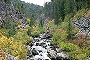
Nez Perce National Forest
Encyclopedia
The Nez Perce National Forest is located in Idaho County
in central western Idaho in the northwestern United States
. The forest
is bounded on the east by the state of Montana
, on the north by the Palouse
region, and on the south and west by the Clearwater National Forest
. It has a total area of 2,224,091 acre
s (3,475.14 sq mi or 9,000.58 km2). Forest headquarters are located in Grangeville, Idaho
. There are local ranger
district offices in Elk City
, Grangeville, Kooskia
, and White Bird
. It is the largest of the six National Forests that are contained entirely within a single county.
 Nez Perce was established on July 1, 1908 by the U.S. Forest Service with 1946340 acres (7,876.6 km²) from parts of Bitter Root National Forest and Weiser National Forest
. On October 29, 1934 part of Selway National Forest
was added.
Idaho County, Idaho
Idaho County is a county located in the U.S. state of Idaho. As of the 2010 Census the county had a population of 16,267. The county seat is Grangeville...
in central western Idaho in the northwestern United States
United States
The United States of America is a federal constitutional republic comprising fifty states and a federal district...
. The forest
Forest
A forest, also referred to as a wood or the woods, is an area with a high density of trees. As with cities, depending where you are in the world, what is considered a forest may vary significantly in size and have various classification according to how and what of the forest is composed...
is bounded on the east by the state of Montana
Montana
Montana is a state in the Western United States. The western third of Montana contains numerous mountain ranges. Smaller, "island ranges" are found in the central third of the state, for a total of 77 named ranges of the Rocky Mountains. This geographical fact is reflected in the state's name,...
, on the north by the Palouse
Palouse
The Palouse is a region of the northwestern United States, encompassing parts of southeastern Washington, north central Idaho and, in some definitions, extending south into northeast Oregon. It is a major agricultural area, primarily producing wheat and legumes...
region, and on the south and west by the Clearwater National Forest
Clearwater National Forest
Clearwater National Forest is located in North Central Idaho in the northwestern United States. The forest is bounded on the east by the state of Montana, on the north by the Idaho Panhandle National Forest, and on the south and west by the Nez Perce National Forest and Palouse Prairie.]The forest...
. It has a total area of 2,224,091 acre
Acre
The acre is a unit of area in a number of different systems, including the imperial and U.S. customary systems. The most commonly used acres today are the international acre and, in the United States, the survey acre. The most common use of the acre is to measure tracts of land.The acre is related...
s (3,475.14 sq mi or 9,000.58 km2). Forest headquarters are located in Grangeville, Idaho
Grangeville, Idaho
Grangeville is the largest city in and the county seat of Idaho County, Idaho, United States, in the west central part of the state. It had a population of 3,141 at the 2010 census.- Culture :...
. There are local ranger
National Park Ranger
National Park Service Rangers are among the uniformed employees charged with protecting and preserving areas set aside in the National Park System by the United States Congress and/or the President of the United States...
district offices in Elk City
Elk City, Idaho
Elk City is an unincorporated census-designated place in Idaho County, Idaho, United States. Elk City is located at the eastern end of Idaho State Highway 14 and is east of Grangeville, the nearest city. Elk City has a post office with ZIP code 83525. As of the 2010 census, its population was 202....
, Grangeville, Kooskia
Kooskia, Idaho
Kooskia is a city in Idaho County, Idaho, United States. The population was 675 at the 2000 census.-Geography:Kooskia is located at ....
, and White Bird
White Bird, Idaho
White Bird is a town in Idaho County, Idaho, United States. The population was 106 at the 2000 census.-Geography:White Bird is located at .According to the United States Census Bureau, the city has a total area of , all of it land....
. It is the largest of the six National Forests that are contained entirely within a single county.

Weiser National Forest
Weiser National Forest in Idaho was established as the Weiser Forest Reserve by the U.S. Forest Service on May 25, 1905 with . It became a National Forest on March 4, 1907. On April 1, 1944 the entire forest was combined with Idaho National Forest to re-establish Payette National Forest, and the...
. On October 29, 1934 part of Selway National Forest
Selway National Forest
Selway National Forest was established by the U.S. Forest Service in Idaho on July 1, 1911 with from parts of Clearwater National Forest and Nez Perce National Forest. On October 29, 1934 the entire forest was divided between Bitterroot, Clearwater, Lolo and Nez Perce, and the name was discontinued...
was added.

