
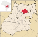
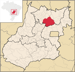
Niquelândia
Encyclopedia
| Niquelândia | |
|---|---|
| State | Goiás Goiás Goiás is a state of Brazil, located in the central part of the country. The name Goiás comes from the name of an indigenous community... |
| Area: | 9,843.0 km² |
| Population: | 38,517 (IBGE 2007) |
| Elevation: | 583m above sea level |
| Postcode (CEP): | 76420-000 |
| IBGE statistical microregion: | 004 Porangatu Microregion Porangatu Microregion The Porangatu Microregion is a statistical region created by IBGE in north-central Goiás state, Brazil. The most important city is Porangatu... |
| Became a city: | 1833 |
| Distance to Goiânia Goiânia -Climate:The city has a tropical wet and dry climate with an average temperature of . There's a wet season, from October to April, and a dry one, from May to September. Annual rainfall is around 1,520 mm.... : |
370 km. |
| Website: | O Portal de Niquelandia |
City
A city is a relatively large and permanent settlement. Although there is no agreement on how a city is distinguished from a town within general English language meanings, many cities have a particular administrative, legal, or historical status based on local law.For example, in the U.S...
and municipality
Municipality
A municipality is essentially an urban administrative division having corporate status and usually powers of self-government. It can also be used to mean the governing body of a municipality. A municipality is a general-purpose administrative subdivision, as opposed to a special-purpose district...
in northern Goiás
Goiás
Goiás is a state of Brazil, located in the central part of the country. The name Goiás comes from the name of an indigenous community...
state, Brazil
Brazil
Brazil , officially the Federative Republic of Brazil , is the largest country in South America. It is the world's fifth largest country, both by geographical area and by population with over 192 million people...
. It is the largest municipality in the state in area and is an important producer of minerals.
Geography
Niquelândia is 300 km from the state capital, Goiânia, and has an elevation of 650 meters above sea level. The average annual temperature is 32 °C, and the climate is tropical humid.The municipality is crossed by highways BR-414 and GO-080, GO-237 e GO-327, besides the various municipal roads that total 12 thousand kilometers.
- Distance from GoiâniaGoiânia-Climate:The city has a tropical wet and dry climate with an average temperature of . There's a wet season, from October to April, and a dry one, from May to September. Annual rainfall is around 1,520 mm....
: 370 kilometers
Highway connections with Goiânia
Goiânia
-Climate:The city has a tropical wet and dry climate with an average temperature of . There's a wet season, from October to April, and a dry one, from May to September. Annual rainfall is around 1,520 mm....
are made by GO-080 / Nerópolis
Nerópolis
Nerópolis is a small city and municipality in central Goiás state, Brazil.-Location:The municipality is part of the metropolitan region of Goiânia, which is 42 kilometers to the west. It is nationally known as the city of garlic and sweets...
/ São Francisco de Goiás
São Francisco de Goiás
São Francisco de Goiás is a small town and municipality in central Goiás state, Brazil.Municipal boundaries:*North: Jaraguá*South: Petrolina de Goiás*East: Pirenópolis*West: Jesúpolis and Jaraguá...
/ BR-153 / Jaraguá / GO-080 / Goianésia
Goianésia
Goianésia is a municipality in the state of Goiás, Brazil. It is a large producer of sugarcane for production of alcohol used as a source of fuel.-Location:...
/ Barro Alto
Barro Alto
Barro Alto is a small town and municipality in northern Goiás state, Brazil, famous for its nickel mine and production of rubber. The population was 6,446 in 2007 and the total area of the municipality was 1,231.8 km².-Location:...
/ GO-342 / BR-080 / BR-153 / Uruaçu
Uruaçu
Uruaçu is a small city and municipality in north Goiás state, Brazil.-Geography:Uruaçu is located north of Anápolis and Goiânia on the important interstate highway BR-153, which links Brasília to Belém. It is 269 km. from Goiânia and 244 km. from Brasília...
/ GO-237.
Municipal boundaries are with Água Fria de Goiás
Água Fria de Goiás
Água Fria de Goiás is a small town and municipality in northern Goiás state, Brazil.-Location:Água Fria became a city in 1989 when it was dismembered from Planaltina de Goiás in 1989. Água Fria is located in the microregion called Entorno de Brasília, although it is almost 156 kilometers to the...
, Alto Paraíso de Goiás
Alto Paraíso de Goiás
Alto Paraíso de Goiás is a small town and a municipality in northeastern Goiás state, Brazil. It has become known for its ecological and New Age tourism.-Location:...
, Barro Alto
Barro Alto
Barro Alto is a small town and municipality in northern Goiás state, Brazil, famous for its nickel mine and production of rubber. The population was 6,446 in 2007 and the total area of the municipality was 1,231.8 km².-Location:...
, Campinaçu
Campinaçu
Campinaçu is a small town and municipality in north Goiás state, Brazil.-Location:Campinaçu is surrounded by the following municipalities:*north: Minaçu*east: Colinas do Sul*west: Campinorte and Uruaçu*south: Niquelândia...
, Colinas do Sul
Colinas do Sul
Colinas do Sul is a small town and municipality in north-central Goiás state, Brazil.-Location:Colinas is located in the Chapada dos Veadeiros statistical micro-region and is almost directly north of Brasília, to which it is connected by G0-327 as far as Alto Paraíso de Goiás then by G0-118 south...
, Mimoso de Goiás
Mimoso de Goiás
Mimoso de Goiás is a small town and municipality in northeastern Goiás state, Brazil.Mimoso is located in statistical microregion 012, called Entorno de Brasília. It is almost directly north of Brasília and is on an unpaved highway linking Padre Bernardo to Água Fria de Goiás...
, Santa Rita do Novo Destino
Santa Rita do Novo Destino
Santa Rita do Novo Destino is a small town and municipality in northeastern Goiás state, Brazil.-Location:Santa Rita do Novo Destino is 82 km. east of Ceres and 15 km. north of Goianésia. Highway connections from Goiânia are made by taking GO-080 / Nerópolis / São Francisco de Goiás / BR-153 /...
, São João d'Aliança
São João d'Aliança
São João d'Aliança is a small town and municipality in northeastern Goiás state, Brazil. São João is a gateway to the Chapada dos Veadeiros National Park. The name is sometimes written as São João D'Aliança.-Location:...
, Uruaçu
Uruaçu
Uruaçu is a small city and municipality in north Goiás state, Brazil.-Geography:Uruaçu is located north of Anápolis and Goiânia on the important interstate highway BR-153, which links Brasília to Belém. It is 269 km. from Goiânia and 244 km. from Brasília...
and Vila Propício
Vila Propício
Vila Propício is a small town and municipality in central Goiás state, Brazil. It is a large producer of sugarcane.-Location:Vila Propício is located in the Entorno de Brasília micro-region and has boundaries with the following municipalities:...
.
The size of the municipal area ranks it below Lebanon and above Cyprus.
Economy
As the name of the city implies Niquelândia is the national capital of nickel. It has one of the largest nickel reserves in the world, which are exploited by two mining companies: Companhia Níquel Tocantins — CNT, belonging to the Votorantim group -, and Codemin - to Anglo American.Although mining is practically all done for nickel, there are also more than 120 types of mineral, such as gold, crystal, platinum, copper, mica, iron, manganese, diamonds, quartz, marble, cobalt, asbestos and even uranium.
The nickel mines bring needed jobs but also cause serious problem to the health of the inhabitants. The ovens to heat the raw material operate at one thousand degrees Celsius and highly toxic ammonia is used in the process. This mixture damages the skin, kidneys, the digestive and the respiratory tract.
Mining is not the only economic activity in the region with cattle raising (250,000 head in 2006), agriculture, small transformation industries, commerce, and public administration employing large segments of the population. In 2007 there were 4 banking agencies: CEF - Banco do Brasil S.A. - Banco Itaú S.A. - Banco ABN AMRO Real S.A (Agosto/2007).
Agricultural Census (2006)
- Farms: 2,168
- Planted area: 15,345 hectares
- Natural Pasture: 53,300 hectares
- Woodland and Forest: 181,389 hectares
- Persons occupied related to the farm owner: 4,543
- Persons occupied not related to the farm owner: 839
- Main crops: soybeans (20,000 hectares), corn (5,000 hectares), and rice (2,000 hectares).
History
Niquelândia is one of the oldest towns in the state of Goiás. It was settled shortly after the arrival of the Portuguese bandeirantes, with the news of the discovery of gold. Niquelândia is one of the oldest municipalities in Goiás. The town was founded in 1735 as São José do Tocantins. In 1938, the German miner Freimund Brockes was panhandling in the region for gold and discovered the second largest nickel deposit in the world. This discovery attracted miners from all over Brazil and the little town grew rapidly. In 1943 the city changed its name to Niquelândia.Tourism
The most important touristic site near the town is the artificial lake of Serra da Mesa. It was created with the construction of the Serra da Mesa DamSerra da Mesa Dam
The Serra da Mesa Dam, once known as Sao Felix, is an embankment dam on the Tocantins River near Minaçu in Goiás, Brazil. The dam serves an associated hydroelectric power plant with a 1,275 MW installed capacity...
, in Minaçu
Minaçu
Minaçu is a small city and municipality in the north of the state of Goiás, Brazil. There is a large asbestos mine in the municipality.-Location and climate:...
, at the end of the nineties. It is formed by the joining of the Maranhão, Tocantinzinho and Bagagem rivers.
Serra da Mesa has one of the largest concentrations of fresh water in the country, with a surface of 1,784 km². With 57% of its area in the municipality of Niquelândia, it has reached a width of 22 km. in the rainy season.
Health and education
- Hospitals: 5 with 167 beds (2007)
- Schools: 40 with 14,365 students (2006)
- Higher education: Unidade Universitária de UEG
- Infant mortality rate in 2000: 26.40
- Literacy rate in 2000: 84.4%
Ranking on the MHDI
See Human Development IndexHuman Development Index
The Human Development Index is a composite statistic used to rank countries by level of "human development" and separate "very high human development", "high human development", "medium human development", and "low human development" countries...
- MHDI: 0.740
- State ranking: 105 (out of 246 municipalities)
- National ranking: 2,160 (out of 5,507 municipalities)
Index of Economic Development (Seplan 2001)
- 39/246 municipalities. See Seplan
Index of Social Development (Seplan 2000)
- 147/246 municipalities. See Seplan