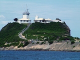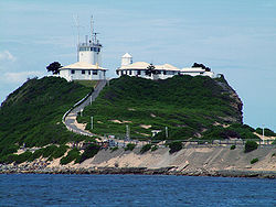
Nobbys Head
Encyclopedia

Headland
A headland is a point of land, usually high and often with a sheer drop, that extends out into a body of water.Headland can also refer to:*Headlands and bays*headLand, an Australian television series...
on the south side of the entrance to Newcastle
Newcastle, New South Wales
The Newcastle metropolitan area is the second most populated area in the Australian state of New South Wales and includes most of the Newcastle and Lake Macquarie Local Government Areas...
Harbour, New South Wales
New South Wales
New South Wales is a state of :Australia, located in the east of the country. It is bordered by Queensland, Victoria and South Australia to the north, south and west respectively. To the east, the state is bordered by the Tasman Sea, which forms part of the Pacific Ocean. New South Wales...
, Australia
Australia
Australia , officially the Commonwealth of Australia, is a country in the Southern Hemisphere comprising the mainland of the Australian continent, the island of Tasmania, and numerous smaller islands in the Indian and Pacific Oceans. It is the world's sixth-largest country by total area...
. It is the location of Nobbys Head Lighthouse, the third lighthouse built in New South Wales
New South Wales
New South Wales is a state of :Australia, located in the east of the country. It is bordered by Queensland, Victoria and South Australia to the north, south and west respectively. To the east, the state is bordered by the Tasman Sea, which forms part of the Pacific Ocean. New South Wales...
after the Macquarie Lighthouse
Macquarie Lighthouse
The Macquarie Lighthouse, also known as South Head Upper Light, was the first, and is the longest serving, lighthouse site in Australia. It is located on Dunbar Head, Vaucluse near the entrance to Sydney Harbour. There has been a navigational aid in this vicinity since 1791 and a lighthouse near...
in 1818 and the Hornby Lighthouse
Hornby Lighthouse
Hornby Lighthouse, also known as South Head Lower Light, is an active lighthouse located on the tip of South Head, New South Wales, Australia, a headland to the north of the suburb Watsons Bay. It marks the southern entrance to Port Jackson and Sydney Harbour, as well as lighting the South Reef, a...
which was also built in 1858. The lighthouse is included in Newcastle's Coat of Arms.
History
Nobbys Head was first sighted by Europeans on 10 May 1770 by Captain James CookJames Cook
Captain James Cook, FRS, RN was a British explorer, navigator and cartographer who ultimately rose to the rank of captain in the Royal Navy...
from the ship Endeavour
HM Bark Endeavour
HMS Endeavour, also known as HM Bark Endeavour, was a British Royal Navy research vessel commanded by Lieutenant James Cook on his first voyage of discovery, to Australia and New Zealand from 1769 to 1771....
and was described by Cook as;
"A small round rock or Island, laying close under the land, bore South 82 degrees West, distance 3 or 4 Leagues".
It was not until the discovery of coal by Lt. John Shortland
John Shortland
John Shortland was a naval officer, the eldest son of John Shortland. Shortland joined the Royal Navy as a midshipman and went to Quebec in a transport commanded by his father. From 1783 to 1787 he served in the West Indies. In 1787 he was master's mate in the Sirius when the First Fleet sailed...
in 1797, that the island was viewed as having any significance.
In 1804, Signal Head was the first place in Newcastle that any form of Navigational aid was set up. Originally a coal burning light, it was changed over to oil in 1821 for a short period of time but was reverted back to coal as the oil system was not reliable.
Governor Macquarie
Lachlan Macquarie
Major-General Lachlan Macquarie CB , was a British military officer and colonial administrator. He served as the last autocratic Governor of New South Wales, Australia from 1810 to 1821 and had a leading role in the social, economic and architectural development of the colony...
ordered a pier to be built to join Coal island to Collier Point. The pier was started on 5 August 1818 and convict labour was used to do the construction. It took 38 years to complete the pier and during this time numerous convicts were lost to the sea due to the convicts having to work through all sea and weather conditions, night and day.
Nobbys Head was thought to have been originally 62 metres (203 ft) high, however work done by the Coal River Working Party in 2010 has concluded that the original height was more likely 27.5 m (90 ft) high. It was reduced to its current 27.5 m (90 ft) height because sailing ships were losing wind in the sails as they rounded Nobbys Head. The rock taken from Nobbys to reduce its height was used in the pier's construction.

