

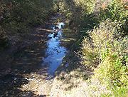
Nonconnah Creek
Encyclopedia
Tennessee
Tennessee is a U.S. state located in the Southeastern United States. It has a population of 6,346,105, making it the nation's 17th-largest state by population, and covers , making it the 36th-largest by total land area...
.
Route description
Nonconnah Creek starts in extreme southeastern Shelby County, TennesseeShelby County, Tennessee
Shelby County is a county located in the U.S. state of Tennessee. It is the state's largest both in terms of population and geographic area, with a population of 927,644 at the 2010 census...
, near the town of Collierville
Collierville, Tennessee
Collierville is a town in Shelby County, Tennessee, United States, and a suburb located in the Memphis metropolitan area. The town had a population of 43,965 at the 2010 census....
. From there, it flows westward, forming the southern border of Germantown
Germantown, Tennessee
Germantown is a city in Shelby County, Tennessee. The population was 38,844 at the 2010 census.Germantown is a suburb of Memphis, bordering it to the east. Germantown's economy is dominated by the retail and commercial service sectors; there is no heavy industry in Germantown...
. The creek
Stream
A stream is a body of water with a current, confined within a bed and stream banks. Depending on its locale or certain characteristics, a stream may be referred to as a branch, brook, beck, burn, creek, "crick", gill , kill, lick, rill, river, syke, bayou, rivulet, streamage, wash, run or...
continues to flow west through Memphis
Memphis, Tennessee
Memphis is a city in the southwestern corner of the U.S. state of Tennessee, and the county seat of Shelby County. The city is located on the 4th Chickasaw Bluff, south of the confluence of the Wolf and Mississippi rivers....
and through Whitehaven
Whitehaven, Memphis
Whitehaven is a predominantly African-American community in Memphis, Tennessee, first organized in the late 19th century. Its current population is about 50,000.-Geography:...
. Nonconnah Creek empties into McKellar Lake, an oxbow
Oxbow lake
An oxbow lake is a U-shaped body of water formed when a wide meander from the main stem of a river is cut off to create a lake. This landform is called an oxbow lake for the distinctive curved shape, named after part of a yoke for oxen. In Australia, an oxbow lake is called a billabong, derived...
of the Mississippi River
Mississippi River
The Mississippi River is the largest river system in North America. Flowing entirely in the United States, this river rises in western Minnesota and meanders slowly southwards for to the Mississippi River Delta at the Gulf of Mexico. With its many tributaries, the Mississippi's watershed drains...
.
Three major expressways follow practically the entire route: Interstate 55
Interstate 55
Interstate 55 is an Interstate Highway in the central United States. Its odd number indicates that it is a north–south Interstate Highway. I-55 goes from LaPlace, Louisiana at Interstate 10 to Chicago at U.S. Route 41 , at McCormick Place. A common nickname for the highway is "double...
, Interstate 240
Interstate 240
Interstate 240 may refer to:* Interstate 240 , a connection into Asheville, North Carolina* Interstate 240 , a freeway on the south side of Oklahoma City* Interstate 240 , a bypass of Memphis, Tennessee...
, and Tennessee State Route 385 (formerly named and still called Nonconnah Parkway).
Drainage basin
The Nonconnah Creek watershedDrainage basin
A drainage basin is an extent or an area of land where surface water from rain and melting snow or ice converges to a single point, usually the exit of the basin, where the waters join another waterbody, such as a river, lake, reservoir, estuary, wetland, sea, or ocean...
covers parts of two counties in Tennessee (Shelby and Fayette) and two counties in Mississippi
Mississippi
Mississippi is a U.S. state located in the Southern United States. Jackson is the state capital and largest city. The name of the state derives from the Mississippi River, which flows along its western boundary, whose name comes from the Ojibwe word misi-ziibi...
(Marshall
Marshall County, Mississippi
-Demographics:At the 2000 census, there were 34,993 people, 12,163 households and 9,110 families residing in the county. The population density was 50 per square mile . There were 13,252 housing units at an average density of 19 per square mile...
and Desoto
DeSoto County, Mississippi
-Demographics:As of the census of 2005 estimate, there were 137,004 people, 38,792 households, and 30,102 families residing in the county. The population density was 224 people per square mile . There were 40,795 housing units at an average density of 85 per square mile...
). The creek drains approximately half of the city of Memphis, the rest being drained by the Wolf River
Wolf River (Tennessee)
The Wolf River is a alluvial stream in western Tennessee and northern Mississippi, whose confluence with the Mississippi River was the site of various Chickasaw, French, Spanish and American communities and forts that eventually became Memphis, Tennessee....
.
Flooding
- Mississippi River Flood Map of 1927Great Mississippi Flood of 1927The Great Mississippi Flood of 1927 was the most destructive river flood in the history of the United States.-Events:The flood began when heavy rains pounded the central basin of the Mississippi in the summer of 1926. By September, the Mississippi's tributaries in Kansas and Iowa were swollen to...
- National Weather Service, Hydrologic Prediction Service, Mississippi River
- U.S. Army Corp of Engineers Mississippi River At Memphis, TN (Weather Bureau Gage)Gage Zero: 183.91 Ft, Record High Stage:48.7 Ft. = 232.61' Memphis River Gage Record High in Feet Above Sea Level
- Federal Emergency Management Agency, FEMA issued Flood Maps
- http://www.commercialappeal.com/photos/galleries/great-flood-1927-and-record-flood-1937/38294/#section_headerPhoto 35, Year 1927, Looking West from U.S. 61 bridge along the sandbagged levee and Photo 39 February 9, 1937. Looking west at Nonconnah Levee and Florida Street along the sandbagged levee. Photo 40 Nonconnah backwater in the vicinity of Federal Compress & Warehouse Company in South Memphis February 9, 1937.]