

Northgate, Crawley
Encyclopedia
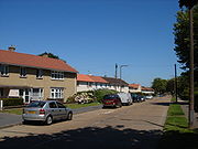
Northgate is a neighbourhood within the town of Crawley
in West Sussex
, England
, and includes the town centre. Northgate is bordered by West Green
to the west, Langley Green
to the north, Three Bridges
to the east and Southgate
to the south.
In the development of the New Town in the 1950s Northgate was the second neighbourhood estate to be built on fields to the north-east of the town. The bulk of the neighbourhood was constructed in 1951-52 by the Development Corporation for the town, but some houses were also built by the Horsham Rural District Council in the early 1950s.
The town centre was also included in the Northgate neighbourhood including the main shopping area of Crawley and the rail and bus stations as was the Manor Royal Industrial Estate to the north of the town and south of Gatwick Airport.
 In common with other Crawley neighbourhoods Northgate was provided with a primary school - originally provided in a prefabricated hut, but permanent buildings were opened in 1953. A parade of shops, a public house and two churches followed in the mid 1950s.
A Royal Electrical and Mechanical Engineers
depot was formerly sited on the London Road, and a Territorial Army (United Kingdom) Centre is in Kilnmead.
Crawley
Crawley is a town and local government district with Borough status in West Sussex, England. It is south of Charing Cross, north of Brighton and Hove, and northeast of the county town of Chichester, covers an area of and had a population of 99,744 at the time of the 2001 Census.The area has...
in West Sussex
West Sussex
West Sussex is a county in the south of England, bordering onto East Sussex , Hampshire and Surrey. The county of Sussex has been divided into East and West since the 12th century, and obtained separate county councils in 1888, but it remained a single ceremonial county until 1974 and the coming...
, England
England
England is a country that is part of the United Kingdom. It shares land borders with Scotland to the north and Wales to the west; the Irish Sea is to the north west, the Celtic Sea to the south west, with the North Sea to the east and the English Channel to the south separating it from continental...
, and includes the town centre. Northgate is bordered by West Green
West Green, Crawley
West Green is one of the 13 residential neighbourhoods in Crawley, a town and borough in West Sussex, England. Crawley was planned and laid out as a New Town after the Second World War, based on the principle of self-contained neighbourhoods surrounding a town centre of civic and commercial buildings...
to the west, Langley Green
Langley Green, Crawley
Langley Green is a neighbourhood within the town of Crawley in West Sussex, England. Langley Green is in the north-west of the town and is bordered by Manor Royal to the east, Northgate to the south east, West Green to the south across the ring road and Ifield to the west. The main streets running...
to the north, Three Bridges
Three Bridges
Three Bridges is a neighbourhood within the town of Crawley, in the county of West Sussex in England.-History:Three Bridges was a tiny hamlet, which first began to grow with the coming of the London and Brighton Railway in 1841...
to the east and Southgate
Southgate, Crawley
Southgate is one of the 13 residential neighbourhoods in Crawley, a town and borough in West Sussex, England. Crawley was planned and laid out as a New Town after the Second World War, based on the principle of self-contained neighbourhoods surrounding a town centre of civic and commercial buildings...
to the south.
History
Before the arrival of the New Town, the name 'Northgate' was associated with the area around the Northgate Toll House located on the London to Brighton road as you entered the town from the North. The area was largely open fields although during the early twentieth century was some ribbon housing development along London Road, Tushmore Lane and Green Lane, Barnfield Road and Woolborough Road.In the development of the New Town in the 1950s Northgate was the second neighbourhood estate to be built on fields to the north-east of the town. The bulk of the neighbourhood was constructed in 1951-52 by the Development Corporation for the town, but some houses were also built by the Horsham Rural District Council in the early 1950s.
The town centre was also included in the Northgate neighbourhood including the main shopping area of Crawley and the rail and bus stations as was the Manor Royal Industrial Estate to the north of the town and south of Gatwick Airport.
Facilities
A Royal Electrical and Mechanical Engineers
Royal Electrical and Mechanical Engineers
The Corps of Royal Electrical and Mechanical Engineers is a corps of the British Army that has responsibility for the maintenance, servicing and inspection of almost every electrical and mechanical piece of equipment within the British Army from Challenger II main battle tanks and WAH64 Apache...
depot was formerly sited on the London Road, and a Territorial Army (United Kingdom) Centre is in Kilnmead.