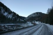
Numedal
Encyclopedia

Districts of Norway
The country Norway is historically divided into a number of districts. Many districts have deep historical roots, and only partially coincide with today's administrative units of counties and municipalities. The districts are defined by geographical features, often valleys, mountain ranges, fjords,...
and valley
Valley
In geology, a valley or dale is a depression with predominant extent in one direction. A very deep river valley may be called a canyon or gorge.The terms U-shaped and V-shaped are descriptive terms of geography to characterize the form of valleys...
Buskerud
Buskerud
is a county in Norway, bordering Akershus, Oslo, Oppland, Sogn og Fjordane, Hordaland, Telemark, and Vestfold. The county administration is located in Drammen.-Geography:...
, Norway
Norway
Norway , officially the Kingdom of Norway, is a Nordic unitary constitutional monarchy whose territory comprises the western portion of the Scandinavian Peninsula, Jan Mayen, and the Arctic archipelago of Svalbard and Bouvet Island. Norway has a total area of and a population of about 4.9 million...
. Running north–south, it extends between Kongsberg
Kongsberg
is a town and municipality in Buskerud county, Norway. It is located at the southern end of the traditional region of Numedal. The administrative centre of the municipality is the town of Kongsberg....
in the south to Rødberg
Rødberg
Rødberg is the administrative centre of Nore og Uvdal municipality, Norway.Rødberg is located in the Norwegian traditional district and valley of Numedal. Its population is 468, and it is located on the Rødberg dam on the Numedalslågen River....
in the north, passing through the municipalities of Kongsberg, Flesberg
Flesberg
Flesberg is a municipality in Buskerud county, Norway. It is part of the traditional region of Numedal. The administrative centre of the municipality is the village of Lampeland....
, Rollag
Rollag
Rollag is a municipality in Buskerud county, Norway. It is part of the traditional region of Numedal. The municipality of Rollag was established on 1 January 1838 . Nore og Uvdal was separated from Rollag in 1858....
and Nore og Uvdal
Nore og Uvdal
Nore og Uvdal is a municipality in Buskerud county, Norway. It is part of the traditional region of Numedal. The administrative centre of the municipality is the village of Rødberg....
.. The river Numedalslågen
Numedalslågen
-Location:Numedalslågen stretches for over 250 kilometres through the counties of Vestfold and Buskerud, beginning at the Hardangervidda plateau and meeting the ocean at Larvik in Vestfold. Numedalslågen is one of Norway's longest rivers. The rivers runs through the municipalities Larvik, Lardal,...
, the third-longest in the country, flows through the valley before discharging into Oslofjord
Oslofjord
The Oslofjord is a bay in the south-east of Norway, stretching from an imaginary line between the Torbjørnskjær and Færder lighthouses and down to Langesund in the south to Oslo in the north....
at Larvik
Larvik
is a city and municipality in Vestfold county, Norway. The administrative centre of the municipality is the city of Larvik. Larvik kommune - has about 41 364 inhabitants and covers 530 km2....
. As of 1 July 2004 the population of Numedal was 6,631, but the population has been consistently decreasing. The Numedal Line runs through the valley, as does National Road 40.
The Norse form of the name was Naumudalr. The first element is the genitive of the rivername Nauma f (now Numedalslågen
Numedalslågen
-Location:Numedalslågen stretches for over 250 kilometres through the counties of Vestfold and Buskerud, beginning at the Hardangervidda plateau and meeting the ocean at Larvik in Vestfold. Numedalslågen is one of Norway's longest rivers. The rivers runs through the municipalities Larvik, Lardal,...
), the last element is dalr m 'dale, valley. The name, and the meaning, is identical with Namdalen
Namdalen
Namdalen is a traditional district in the central part of Norway, consisting of the municipalities Namsos, Grong, Overhalla, Røyrvik, Fosnes, Nærøy, Høylandet, Namdalseid, Flatanger, Lierne, Leka, Namsskogan, and Vikna, all in Nord-Trøndelag county. The district has two towns: Kolvereid and Namsos...
.
The area along the Numedalslågen from Kongsberg up to the Hardangervidda
Hardangervidda
The Hardangervidda is a mountain plateau in the Hardanger region of western Norway. It is the largest such plateau in Europe, with a cold year-round alpine climate and is the site of one of Norway's largest glaciers. Much of the plateau is protected as part of Hardangervidda National Park; it is a...
through the valley had the highest concentration of medieval log buildings. Numedal has long been the location of the Norwegian paths (Nordmannsslepene) which were the main traffic artery between Østlandet and Vestlandet. The path is marked, and when one treks along the old way, one sees the remains of Stone Age
Stone Age
The Stone Age is a broad prehistoric period, lasting about 2.5 million years , during which humans and their predecessor species in the genus Homo, as well as the earlier partly contemporary genera Australopithecus and Paranthropus, widely used exclusively stone as their hard material in the...
dwelling places, bog iron
Bog iron
Bog iron refers to impure iron deposits that develop in bogs or swamps by the chemical or biochemical oxidation of iron carried in the solutions. In general, bog ores consist primarily of iron oxyhydroxides, commonly goethite...
works, grave mounds and many more signs of activity over a period of 8000 years. There are still over 40 ancient timber buildings and 4 stave church
Stave church
A stave church is a medieval wooden church with a post and beam construction related to timber framing. The wall frames are filled with vertical planks. The load-bearing posts have lent their name to the building technique...
es remaining.

