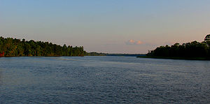
Ogeechee River
Encyclopedia


River
A river is a natural watercourse, usually freshwater, flowing towards an ocean, a lake, a sea, or another river. In a few cases, a river simply flows into the ground or dries up completely before reaching another body of water. Small rivers may also be called by several other names, including...
in the U.S.
United States
The United States of America is a federal constitutional republic comprising fifty states and a federal district...
state of Georgia
Georgia (U.S. state)
Georgia is a state located in the southeastern United States. It was established in 1732, the last of the original Thirteen Colonies. The state is named after King George II of Great Britain. Georgia was the fourth state to ratify the United States Constitution, on January 2, 1788...
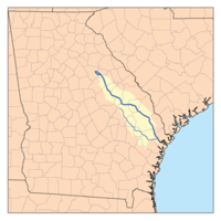
. It heads at the confluence of its North and South Forks, about 2.5 miles (4 km) south-southwest of Crawfordville
Crawfordville, Georgia
Crawfordville is a city in Taliaferro County, Georgia, United States. The population was 572 at the 2000 census. The city is the county seat of Taliaferro County.-Geography:Crawfordville is located at ....
and flowing generally southeast to Ossabaw Sound about 16 miles (25.7 km) south of Savannah
Savannah, Georgia
Savannah is the largest city and the county seat of Chatham County, in the U.S. state of Georgia. Established in 1733, the city of Savannah was the colonial capital of the Province of Georgia and later the first state capital of Georgia. Today Savannah is an industrial center and an important...
. Its largest tributary
Tributary
A tributary or affluent is a stream or river that flows into a main stem river or a lake. A tributary does not flow directly into a sea or ocean...
is the Canoochee River
Canoochee River
The Canoochee River is a river in southeastern Georgia in the United States. It is a tributary of the Ogeechee River, which flows to the Atlantic Ocean.-Course:...
. The Ogeechee has a watershed of 5540 square miles (14,348.5 km²).
The Ogeechee runs its course from the Piedmont
Piedmont (United States)
The Piedmont is a plateau region located in the eastern United States between the Atlantic Coastal Plain and the main Appalachian Mountains, stretching from New Jersey in the north to central Alabama in the south. The Piedmont province is a physiographic province of the larger Appalachian division...
across the fall line
Fall line
A fall line is a geomorphologic unconformity between an upland region of relatively hard crystalline basement rock and a coastal plain of softer sedimentary rock. A fall line is typically prominent when crossed by a river, for there will often be rapids or waterfalls...
and sand hill region then across the coastal plain of Georgia. From a shallow clear running stream with several shoals, rapids, and a small falls at Shoals Georgia, below Louisville
Louisville, Georgia
Louisville is a city in Jefferson County, Georgia, United States. It is the former capital of Georgia and is the county seat of Jefferson County. It is located southwest of Augusta on the Ogeechee River, and its population was 2,712 at the 2000 census. The local pronunciation is the Americanized...
the river becomes a lazy meandering channel through beautiful cypress swamps and miles of undeveloped forests.
The origin of the name "Ogeechee" is uncertain, but it might come from a Muskogee
Muskogean languages
Muskogean is an indigenous language family of the Southeastern United States. Though there is an ongoing debate concerning their interrelationships, the Muskogean languages are generally divided into two branches, Eastern Muskogean and Western Muskogean...
term meaning "river of the Uchees", referring to the Yuchi
Yuchi
For the Chinese surname 尉迟, see Yuchi.The Yuchi, also spelled Euchee and Uchee, are a Native American Indian tribe who traditionally lived in the eastern Tennessee River valley in Tennessee in the 16th century. During the 17th century, they moved south to Alabama, Georgia and South Carolina...
.
Hernando de Soto crossed the Ogeechee between Sandersville
Sandersville, Georgia
Sandersville is a city in Washington County, Georgia, United States. The population was 6,097 at the 2010 census. The city is the county seat of Washington County...
and Louisville on April 22, 1541, during his exploration of the southeast part of North America.
Archaeologist and medical doctor George Pilcher with the aid of the Smithsonian
Smithsonian Institution
The Smithsonian Institution is an educational and research institute and associated museum complex, administered and funded by the government of the United States and by funds from its endowment, contributions, and profits from its retail operations, concessions, licensing activities, and magazines...
dated Native American settlements and burial grounds along the Ogeechee to 8000 BC.
The Ogeechee - A river and its people is a book by the late photographer Jack Leigh. It is the only book that Leigh wrote text for as accompaniment to his photographs. The book features a good deal of geographic information as Leigh traced the river from its source to the ocean. The book is also an intimate exploration of the culture that has evolved along the river's meanders.

