Oostflakkee
Encyclopedia
 Oostflakkee is a municipality on the island of Goeree-Overflakkee
Goeree-Overflakkee
Goeree-Overflakkee is the southernmost delta island of the province of South Holland, Netherlands. It is separated from Voorne-Putten and Hoeksche Waard by the Haringvliet, from the mainland of North Brabant by the Volkerak, and from Schouwen-Duiveland by Lake Grevelingen.From west to east, it...
in the western Netherlands
Netherlands
The Netherlands is a constituent country of the Kingdom of the Netherlands, located mainly in North-West Europe and with several islands in the Caribbean. Mainland Netherlands borders the North Sea to the north and west, Belgium to the south, and Germany to the east, and shares maritime borders...
, in the province of South Holland
South Holland
South Holland is a province situated on the North Sea in the western part of the Netherlands. The provincial capital is The Hague and its largest city is Rotterdam.South Holland is one of the most densely populated and industrialised areas in the world...
. The municipality covers an area of 107.44 km² (of which 32.75 km² is covered by water).
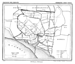
The municipality of Oostflakkee was formed by the amalgamation of the former municipalities of Den Bommel, Ooltgensplaat, and Oude Tonge in 1966. It consists of the communities Achthuizen, De Langstraat, Den Bommel (with Zuidzijde), Ooltgensplaat, Oude-Tonge, Zuidzijde.
Oude Tonge is the main town of this municipality with a considerable industrial area. It also has a large busstation. Den Bommel is quite similar as Stad aan 't Haringvliet
Stad aan 't Haringvliet
Stad aan 't Haringvliet is a town in the Dutch province of South Holland. It is a part of the municipality of Middelharnis, and lies about 12 km southeast of Hellevoetsluis. The name means City on the Haringvliet...
with a harbor and beach on the shores of the Haringvliet
Haringvliet
The Haringvliet is a large inlet of the North Sea, in the province of South Holland in the Netherlands. It is an important estuary of the Rhine-Meuse delta.Near Numansdorp, the Hollands Diep splits into the Haringvliet and the Volkerak estuaries...
. A few kilometers east of Den Bommel there is Zuidzijde, a very small town with a neat looking watertower. Ooltgensplaat is the most eastward town on the island with a harbor on the Volkerak. The town has a very old and beautiful municipal building. This town is the yearly start and finish of De Omloop - a 100+ km walk around the island in a 24 hour period. This event attracts thousands every year either participants or bystanders. It is held yearly in the latter half of August. Achthuizen and Langstraat are other small towns nearby Ooltgensplaat.

External links
- Official Website
- http://www.plattegronden.nl/goeree-overflakkee/

