Organ Mountains
Encyclopedia
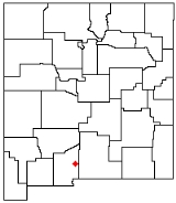
The Organ Mountains are a rugged mountain range in southern New Mexico
in the Southwestern United States
. They lie 10 miles (16 km) east of the city of Las Cruces
, in Doña Ana County
.
's rift valley
. The range is nearly contiguous with the San Andres Mountains
to the north and the Franklin Mountains
to the south, but is very different geologically. Whereas the San Andres and Franklin Mountains are both formed from west-dipping fault blocks
of mostly sedimentary strata (with limestone
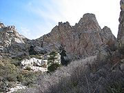
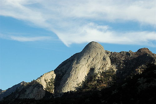
most prominent), the Organ Mountains are made primarily of igneous rock (intrusive granite
and extrusive rhyolite
). Their name reflects their similarity in appearance (particularly the granite "needles" in the highest part of the range) with pipes that would be part of a pipe organ
.
The San Andres Mountains
-(southern subrange of San Augustin Mountains
), are separated from the Organ Mountains by San Augustin Pass, through which U.S. Highway 70 passes on its way to White Sands Missile Range
, White Sands National Monument
and Alamogordo
. The Franklin Mountains
are separated from the Organ Mountains by a 10-mile wide low area known as Anthony Gap. Much of this intervening land is part of Fort Bliss
.

, with approximately 870 vascular plant species. Several of these, including the Organ Mountains evening-primrose (Oenothera organensis) and smooth figwort (Scrophularia laevis), are endemic to the mountain range and occur only in small, scattered populations.
The Organ Mountains also have surprisingly high diversity in fern
s, with 30 of the 56 species reported for New Mexico occurring within it. The high diversity and endemism of the range makes the Organ Mountains a very rewarding destination for the botanically-inclined, as well as a focus of botanical study.
The flora differs greatly between the three sections of the mountain range, with the two igneous sections (The Needles and the central extrusive portion) sharing relatively few species with the southern limestone portions. The limestone section includes some of the northernmost populations of lechuguilla (Agave lecheguilla), often considered an indicator species of the Chihuahuan Desert
, whereas the igneous sections of the range include all of the endemic taxa and have botanical affinity with Madrean flora typical of the southeastern Arizona
sky islands
.
The southern limestone section is difficult to access and rarely visited. Bishop's Cap can be reached through rugged dirt roads, but has no developed trails. Rattlesnake Ridge is entirely within Fort Bliss and inaccessible to the general public.
New Mexico
New Mexico is a state located in the southwest and western regions of the United States. New Mexico is also usually considered one of the Mountain States. With a population density of 16 per square mile, New Mexico is the sixth-most sparsely inhabited U.S...
in the Southwestern United States
Southwestern United States
The Southwestern United States is a region defined in different ways by different sources. Broad definitions include nearly a quarter of the United States, including Arizona, California, Colorado, Nevada, New Mexico, Oklahoma, Texas and Utah...
. They lie 10 miles (16 km) east of the city of Las Cruces
Las Cruces, New Mexico
Las Cruces, also known as "The City of the Crosses", is the county seat of Doña Ana County, New Mexico, United States. The population was 97,618 in 2010 according to the 2010 Census, making it the second largest city in the state....
, in Doña Ana County
Doña Ana County, New Mexico
-2010:Whereas according to the 2010 U.S. Census Bureau:*74.1% White*1.7% Black*1.5% Native American*1.1% Asian*0.1% Native Hawaiian or Pacific Islander*3.0% Two or more races*18.5% Other races*65.7% Hispanic or Latino -2000:...
.
Geography
The Organ Mountains are near the southern end of a long line of mountains on the east side of the Rio GrandeRio Grande
The Rio Grande is a river that flows from southwestern Colorado in the United States to the Gulf of Mexico. Along the way it forms part of the Mexico – United States border. Its length varies as its course changes...
's rift valley
Rio Grande Rift
The Rio Grande Rift is a north-trending continental rift zone. It separates the Colorado Plateau in the west from the interior of the North American craton on the east. The rift extends from central Colorado in the north to the state of Chihuahua, Mexico in the south. The rift zone consists of four...
. The range is nearly contiguous with the San Andres Mountains
San Andres Mountains
The San Andres Mountains are a mountain range in the southwestern U.S. state of New Mexico, in the counties of Socorro, Sierra, and Doña Ana. The range extends about 75 miles north to south, but are only about 12 miles wide at their widest...
to the north and the Franklin Mountains
Franklin Mountains (Texas)
The Franklin Mountains of Texas are a small range that extend from El Paso, Texas north into New Mexico. The Franklins were formed due to crustal extension related to the Cenozoic Rio Grande rift...
to the south, but is very different geologically. Whereas the San Andres and Franklin Mountains are both formed from west-dipping fault blocks
Fault-block mountain
Fault-block landforms are formed when large areas of bedrock are widely broken up by faults creating large vertical displacements of continental crust....
of mostly sedimentary strata (with limestone
Limestone
Limestone is a sedimentary rock composed largely of the minerals calcite and aragonite, which are different crystal forms of calcium carbonate . Many limestones are composed from skeletal fragments of marine organisms such as coral or foraminifera....
most prominent), the Organ Mountains are made primarily of igneous rock (intrusive granite
Granite
Granite is a common and widely occurring type of intrusive, felsic, igneous rock. Granite usually has a medium- to coarse-grained texture. Occasionally some individual crystals are larger than the groundmass, in which case the texture is known as porphyritic. A granitic rock with a porphyritic...
and extrusive rhyolite
Rhyolite
This page is about a volcanic rock. For the ghost town see Rhyolite, Nevada, and for the satellite system, see Rhyolite/Aquacade.Rhyolite is an igneous, volcanic rock, of felsic composition . It may have any texture from glassy to aphanitic to porphyritic...
). Their name reflects their similarity in appearance (particularly the granite "needles" in the highest part of the range) with pipes that would be part of a pipe organ
Pipe organ
The pipe organ is a musical instrument that produces sound by driving pressurized air through pipes selected via a keyboard. Because each organ pipe produces a single pitch, the pipes are provided in sets called ranks, each of which has a common timbre and volume throughout the keyboard compass...
.
The San Andres Mountains
San Andres Mountains
The San Andres Mountains are a mountain range in the southwestern U.S. state of New Mexico, in the counties of Socorro, Sierra, and Doña Ana. The range extends about 75 miles north to south, but are only about 12 miles wide at their widest...
-(southern subrange of San Augustin Mountains
San Augustin Mountains
The San Augustin Mountains are a small mountain subrange at the southern terminus of the San Andres Mountains east of Las Cruces, New Mexico. Organ lies at the southwest foothills; the townsite, White Sands, NM lies to the southeast at the southwest of the Tularosa Valley.-Description:The San...
), are separated from the Organ Mountains by San Augustin Pass, through which U.S. Highway 70 passes on its way to White Sands Missile Range
White Sands Missile Range
White Sands Missile Range is a rocket range of almost in parts of five counties in southern New Mexico. The largest military installation in the United States, WSMR includes the and the WSMR Otera Mesa bombing range...
, White Sands National Monument
White Sands National Monument
The White Sands National Monument is a U.S. National Monument located about southwest of Alamogordo in western Otero County and northeastern Dona Ana County in the state of New Mexico, at an elevation of 4235 feet...
and Alamogordo
Alamogordo, New Mexico
Alamogordo is the county seat of Otero County and a city in south-central New Mexico, United States. A desert community lying in the Tularosa Basin, it is bordered on the east by the Sacramento Mountains. It is the nearest city to Holloman Air Force Base. The population was 35,582 as of the 2000...
. The Franklin Mountains
Franklin Mountains (Texas)
The Franklin Mountains of Texas are a small range that extend from El Paso, Texas north into New Mexico. The Franklins were formed due to crustal extension related to the Cenozoic Rio Grande rift...
are separated from the Organ Mountains by a 10-mile wide low area known as Anthony Gap. Much of this intervening land is part of Fort Bliss
Fort Bliss
Fort Bliss is a United States Army post in the U.S. states of New Mexico and Texas. With an area of about , it is the Army's second-largest installation behind the adjacent White Sands Missile Range. It is FORSCOM's largest installation, and has the Army's largest Maneuver Area behind the...
.
Geology
The Organ Mountains are made up of three major sections:- On the north end is a narrow ridge of vertically-jointed Tertiary graniteGraniteGranite is a common and widely occurring type of intrusive, felsic, igneous rock. Granite usually has a medium- to coarse-grained texture. Occasionally some individual crystals are larger than the groundmass, in which case the texture is known as porphyritic. A granitic rock with a porphyritic...
(more specifically, quartz monzoniteQuartz monzoniteQuartz monzonite is an intrusive igneous rock that has an approximately equal proportion of orthoclase and plagioclase feldspars. The plagioclase is typically intermediate to sodic in composition, andesine to oligoclase. Quartz is present in significant amounts. Biotite and/or hornblende...
) called The Needles. This is the most picturesque section and includes the tallest point in the range, Organ NeedleOrgan NeedleOrgan Needle is the highest point of the Organ Mountains in the south-central part of the US state of New Mexico. It lies in Doña Ana County, east-northeast of Las Cruces and southwest of White Sands, headquarters of the White Sands Missile Range...
at an elevation of 8,990 feet (2,740 m). - On the south side of The Needles is a much wider section of extrusive igneous rockIgneous rockIgneous rock is one of the three main rock types, the others being sedimentary and metamorphic rock. Igneous rock is formed through the cooling and solidification of magma or lava...
, mostly a purplish-gray rhyoliteRhyoliteThis page is about a volcanic rock. For the ghost town see Rhyolite, Nevada, and for the satellite system, see Rhyolite/Aquacade.Rhyolite is an igneous, volcanic rock, of felsic composition . It may have any texture from glassy to aphanitic to porphyritic...
. This section forms the bulk of the mountain range and reaches heights nearly as great as The Needles. This section is cut in half by Soledad Canyon, which extends west from the east side of the range, separated by a low ridge from Bar Canyon on the west side. - The third portion of the Organ Mountains consists of the Bishop's Cap Hills on the southwest side of the range and Rattlesnake Ridge on the southeast side of the range. This third section is much smaller and lower in elevation than the other sections of the range, and consists of fault-block limestone similar to that of the San Andres and Franklin Mountains.


Botany
The Organ Mountains may be the most botanically diverse mountain range in New MexicoNew Mexico
New Mexico is a state located in the southwest and western regions of the United States. New Mexico is also usually considered one of the Mountain States. With a population density of 16 per square mile, New Mexico is the sixth-most sparsely inhabited U.S...
, with approximately 870 vascular plant species. Several of these, including the Organ Mountains evening-primrose (Oenothera organensis) and smooth figwort (Scrophularia laevis), are endemic to the mountain range and occur only in small, scattered populations.
The Organ Mountains also have surprisingly high diversity in fern
Fern
A fern is any one of a group of about 12,000 species of plants belonging to the botanical group known as Pteridophyta. Unlike mosses, they have xylem and phloem . They have stems, leaves, and roots like other vascular plants...
s, with 30 of the 56 species reported for New Mexico occurring within it. The high diversity and endemism of the range makes the Organ Mountains a very rewarding destination for the botanically-inclined, as well as a focus of botanical study.
The flora differs greatly between the three sections of the mountain range, with the two igneous sections (The Needles and the central extrusive portion) sharing relatively few species with the southern limestone portions. The limestone section includes some of the northernmost populations of lechuguilla (Agave lecheguilla), often considered an indicator species of the Chihuahuan Desert
Chihuahuan Desert
The Chihuahuan Desert is a desert, and an ecoregion designation, that straddles the U.S.-Mexico border in the central and northern portions of the Mexican Plateau, bordered on the west by the extensive Sierra Madre Occidental range, and overlaying northern portions of the east range, the Sierra...
, whereas the igneous sections of the range include all of the endemic taxa and have botanical affinity with Madrean flora typical of the southeastern Arizona
Arizona
Arizona ; is a state located in the southwestern region of the United States. It is also part of the western United States and the mountain west. The capital and largest city is Phoenix...
sky islands
Sky Islands
Sky Islands is a 1993 Jazz album by Ramsey Lewis released on GRP Records.The album peaked at #4 on the Billboard Top Contemporary Jazz Albums chart.-Track listing:-Personnel: *Tony Carpenter - Percussion, Background Vocals...
.
Hiking
The Bureau of Land Management maintains trails accessed from four sites in the Organ Mountains.- Aguirre Springs Campground and Baylor Canyon Road offer access to trails in The Needles from the east and west sides, respectively. Trails include the 4.5 mile Pine Tree Trail loop, where visitors can hike from 5,600 feet up to 6,880 feet. This trail covers a wide ecological range, from lower-elevation mountain mahogany scrub to ponderosa pine woodland on its upper parts.
- Dripping Springs Natural Area on the west side of the central rhyolitic portion of the Organ Mountains has a set of interconnected low-elevation trails around La Cueva and entering the lower parts of Fillmore and Ice Canyons.
- The Soledad Canyon Day Use Area provides a loop trail in the lower part of Bar Canyon, south of Dripping Springs on the west side of the range.
The southern limestone section is difficult to access and rarely visited. Bishop's Cap can be reached through rugged dirt roads, but has no developed trails. Rattlesnake Ridge is entirely within Fort Bliss and inaccessible to the general public.

