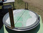
Osborne Fire Finder
Encyclopedia

Fire lookout
A fire lookout is a person assigned the duty to look for fire from atop a building known as a fire lookout tower. These towers are used in remote areas, normally on mountain tops with high elevation and a good view of the surrounding terrain, to spot smoke caused by a wildfire.Once a possible fire...
s in order to find a directional bearing (azimuth) to smoke in order to alert fire crews to a wildland fire
Wildfire
A wildfire is any uncontrolled fire in combustible vegetation that occurs in the countryside or a wilderness area. Other names such as brush fire, bushfire, forest fire, desert fire, grass fire, hill fire, squirrel fire, vegetation fire, veldfire, and wilkjjofire may be used to describe the same...
.
History and development
The device was invented by William "W.B." Osborne, a United States Forest ServiceUnited States Forest Service
The United States Forest Service is an agency of the United States Department of Agriculture that administers the nation's 155 national forests and 20 national grasslands, which encompass...
employee from Portland, Oregon
Portland, Oregon
Portland is a city located in the Pacific Northwest, near the confluence of the Willamette and Columbia rivers in the U.S. state of Oregon. As of the 2010 Census, it had a population of 583,776, making it the 29th most populous city in the United States...
, and has been in service since 1915. Mr. Osborne also designed the photo-recording transit for making panoramic records of forest conditions, as well as a collapsible water-bag knapsack for firefighting (U.S. patented in 1935). Many fire finders were manufactured from 1920 through 1935, but the manufacturer, Leupold & Stevens, Inc., stopped production of replacement parts after 1975.
In recent years, with the resurgence and recovery of fire lookout towers, new Osborne devices were needed. The U.S. Forest Service, San Dimas Technology and Development Center (SDTDC) was contacted regarding the deteriorating condition of the Osborne Fire Finders housed in fire lookouts throughout the United States. A pilot program to create new Osbornes was coordinated with manufacturer, Palmquist Tooling, Inc. and now Osborne Fire Finders are available again.
Use of the Fire Finder
The system is composed of a topographic mapTopographic map
A topographic map is a type of map characterized by large-scale detail and quantitative representation of relief, usually using contour lines in modern mapping, but historically using a variety of methods. Traditional definitions require a topographic map to show both natural and man-made features...
of the area oriented and centered on a horizontal table with a circular rim graduated in degrees (and fractions). Two sighting apertures are mounted above the map on opposite sides of the ring and slide around the arc.

Resection (orientation)
Resection is a method for determining a position using a compass and topographic map .-Resection versus intersection:...
method to fix the precise location of the fire. Dispatchers at a central facility used a compass rose
Compass rose
A compass rose, sometimes called a windrose, is a figure on a compass, map, nautical chart or monument used to display the orientation of the cardinal directions — North, East, South and West - and their intermediate points. It is also the term for the graduated markings found on the traditional...
to mark lines of position from each reporting tower onto a large map to quickly find where the reported bearings intersect.
Today, a more precise determination of a fire location can be made by the use of a single Fire Finder in conjunction with a digital elevation model (DEM).
See also
- History of the Osborne Fire Finder by Ray Kresek
- Fire lookout towerFire lookout towerA fire lookout tower, fire tower or lookout tower, provides housing and protection for a person known as a "fire lookout" whose duty it is to search for wildfires in the wilderness...
- Fire LookoutFire lookoutA fire lookout is a person assigned the duty to look for fire from atop a building known as a fire lookout tower. These towers are used in remote areas, normally on mountain tops with high elevation and a good view of the surrounding terrain, to spot smoke caused by a wildfire.Once a possible fire...
- Alidade

