
Paradise Hills, San Diego, California
Encyclopedia
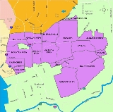
Paradise Hills is a neighborhood in the southeastern area of the city of San Diego, California
. It is an outlying neighborhood adjacent to the independent city of National City
and the unincorporated communities of Lincoln Acres
and certain portions of Bonita
.
Demographic statistics are only available for the wider 92139 ZIP code which includes all of Paradise Hills and a portion of neighboring Bay Terraces; in this ZIP code, people of Asian or Pacific Islander heritage make up the plurality of residents (37.2%, most of which reside in adjacent Bay Terraces), followed by Hispanics of all races (29.9%, with the majority residing west of Dusk Drive), non-Hispanic Whites (14.9%), and Blacks (12.6%).
Geographically, Paradise Hills encompasses the area east of Rachael Avenue (the boundary between San Diego and National City), south of Paradise Valley Road (a boundary with another San Diego neighborhood, Bay Terraces), north of State Route 54
(a boundary between San Diego and Bonita), and west of Dusk Drive and Potomac Street (another boundary with Bay Terraces). Stemming from old gang-enforced boundaries, "Paradise Hills" is sometimes incorrectly used to locate any place near the Skyline-Paradise Hills Community which includes the neighborhoods Skyline, Paradise Hills, Bay Terraces, Lomita, and the Meadowbrook Housing Project.
Public elementary schools located in Paradise Hills are Lee Elementary, Paradise Hills Elementary, and Perry Elementary; Penn Elementary lies on the border between Paradise Hills and Bay Terraces. Public secondary schools serving Paradise Hills residents are Bell Middle School and Morse High School (both in neighboring Bay Terraces and Skyline, respectively); San Diego School of Creative and Performing Arts (SCPA) also lies on the border between Paradise Hills and Bay Terraces. SCPA provides education from 9th through 12th grades with an added emphasis on performing arts. The largest private school in Paradise Hills, St. Michael's Catholic School, provides education from Kindergarten through 8th grade.
Recreation centers in and bordering the neighborhood include Charles L. Lewis III Memorial Skate Park, Paradise Hills Recreation Center, and Penn Athletic Field.
California
California is a state located on the West Coast of the United States. It is by far the most populous U.S. state, and the third-largest by land area...
. It is an outlying neighborhood adjacent to the independent city of National City
National City, California
National City is a city in San Diego County, California. The population was 58,582 at the 2010 census, up from 54,260 at the 2000 census. National City is the second oldest city in San Diego County and has a historic past.-History:...
and the unincorporated communities of Lincoln Acres
Lincoln Acres, California
Lincoln Acres is an unincorporated area of San Diego County located wholly within the boundaries of the incorporated city of National City. It has a population of approximately 2,100 residents. Lincoln Acres has a fire station and library, but relies on the San Diego County Sheriff's Department to...
and certain portions of Bonita
Bonita, California
Bonita is a census-designated place in southern San Diego County, California, nestled between the cities of Chula Vista, National City, and San Diego. The population was 12,538 at the 2010 census.-Geography:Bonita is located at ....
.
Demographic statistics are only available for the wider 92139 ZIP code which includes all of Paradise Hills and a portion of neighboring Bay Terraces; in this ZIP code, people of Asian or Pacific Islander heritage make up the plurality of residents (37.2%, most of which reside in adjacent Bay Terraces), followed by Hispanics of all races (29.9%, with the majority residing west of Dusk Drive), non-Hispanic Whites (14.9%), and Blacks (12.6%).
Geographically, Paradise Hills encompasses the area east of Rachael Avenue (the boundary between San Diego and National City), south of Paradise Valley Road (a boundary with another San Diego neighborhood, Bay Terraces), north of State Route 54
California State Route 54
State Route 54 is a California State Highway in San Diego that connects Interstate 5 to the city of El Cajon. The first section was built circa 1961, and the final section of freeway opened in 2007....
(a boundary between San Diego and Bonita), and west of Dusk Drive and Potomac Street (another boundary with Bay Terraces). Stemming from old gang-enforced boundaries, "Paradise Hills" is sometimes incorrectly used to locate any place near the Skyline-Paradise Hills Community which includes the neighborhoods Skyline, Paradise Hills, Bay Terraces, Lomita, and the Meadowbrook Housing Project.
Public elementary schools located in Paradise Hills are Lee Elementary, Paradise Hills Elementary, and Perry Elementary; Penn Elementary lies on the border between Paradise Hills and Bay Terraces. Public secondary schools serving Paradise Hills residents are Bell Middle School and Morse High School (both in neighboring Bay Terraces and Skyline, respectively); San Diego School of Creative and Performing Arts (SCPA) also lies on the border between Paradise Hills and Bay Terraces. SCPA provides education from 9th through 12th grades with an added emphasis on performing arts. The largest private school in Paradise Hills, St. Michael's Catholic School, provides education from Kindergarten through 8th grade.
Recreation centers in and bordering the neighborhood include Charles L. Lewis III Memorial Skate Park, Paradise Hills Recreation Center, and Penn Athletic Field.