Patos Island (Venezuela)
Encyclopedia


Caribbean Sea
The Caribbean Sea is a sea of the Atlantic Ocean located in the tropics of the Western hemisphere. It is bounded by Mexico and Central America to the west and southwest, to the north by the Greater Antilles, and to the east by the Lesser Antilles....
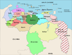
. The island is a part of the Dependencias Federales (Federal Dependencies
Federal dependencies of Venezuela
The Federal Dependencies of Venezuela encompass all of Venezuela's off shore islands in the Caribbean Sea and the Gulf of Venezuela...
) of Venezuela
Venezuela
Venezuela , officially called the Bolivarian Republic of Venezuela , is a tropical country on the northern coast of South America. It borders Colombia to the west, Guyana to the east, and Brazil to the south...
.
Geography
Patos Island is located about 250 km (155.3 mi) northeast of CaracasCaracas
Caracas , officially Santiago de León de Caracas, is the capital and largest city of Venezuela; natives or residents are known as Caraquenians in English . It is located in the northern part of the country, following the contours of the narrow Caracas Valley on the Venezuelan coastal mountain range...
in the Golfo de Paria (Gulf of Paria
Gulf of Paria
The Gulf of Paria is a shallow inland sea between the island of Trinidad and the east coast of Venezuela. This sheltered body of water is considered to be one of the best natural harbours on the Atlantic coast of the Americas...
). The coordinates are 10°38′18"N 61°51′50"W. It lies in the Boca Grande strait
Strait
A strait or straits is a narrow, typically navigable channel of water that connects two larger, navigable bodies of water. It most commonly refers to a channel of water that lies between two land masses, but it may also refer to a navigable channel through a body of water that is otherwise not...
of the Bocas del Dragón
Bocas del Dragón
The Bocas del Dragón is the name of the series of straits separating the Gulf of Paria from the Caribbean Sea. There are four Bocas, from west to east they are:...
(Dragon's Mouth), approximately 4 km off the coast of mainland Venezuela and about 10 km west-south-west of Chacachacare
Chacachacare
Chacachacare is an abandoned island in the Republic of Trinidad and Tobago located at 10° 41' north latitude and 61° 45' west longitude. The island is 3.642 km² in area. It is one of the "Bocas Islands", which lie in the Bocas del Dragón between Trinidad and Venezuela...
, which is part of Trinidad and Tobago
Trinidad and Tobago
Trinidad and Tobago officially the Republic of Trinidad and Tobago is an archipelagic state in the southern Caribbean, lying just off the coast of northeastern Venezuela and south of Grenada in the Lesser Antilles...
.
The uninhabited island has an area of only 0.65 square km (0,25 square miles) with a length of 1.1 km (0.683510010314787 mi) and 6 km (3.7 mi) wide with the highest point reaching about 100 meters (328 feet).
History
Patos Island was part of the former British colony Trinidad and TobagoTrinidad and Tobago
Trinidad and Tobago officially the Republic of Trinidad and Tobago is an archipelagic state in the southern Caribbean, lying just off the coast of northeastern Venezuela and south of Grenada in the Lesser Antilles...
.
On 26 February 1942 the island became part of Venezuela and was put under the administration of the Ministerio del Interior y de Justicia (Ministry of Interior and Justice) as part of the Dependencias Federales.
On 9 August 1972 the island, together with the other islands of the Dependencias Federales, were declared a national park
National park
A national park is a reserve of natural, semi-natural, or developed land that a sovereign state declares or owns. Although individual nations designate their own national parks differently A national park is a reserve of natural, semi-natural, or developed land that a sovereign state declares or...
(Archipiélago Los Roques National Park) with the park being established on 18 August.

