Peng Chau
Encyclopedia


Island
An island or isle is any piece of sub-continental land that is surrounded by water. Very small islands such as emergent land features on atolls can be called islets, cays or keys. An island in a river or lake may be called an eyot , or holm...
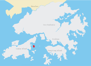
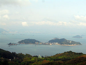
located off the north-eastern coast of Lantau Island
Lantau Island
Lantau Island , based on the old local name of Lantau Peak , is the largest island in Hong Kong, located at the mouth of the Pearl River. Administratively, most of Lantau Island is part of the Islands District of Hong Kong...
, Hong Kong
Hong Kong
Hong Kong is one of two Special Administrative Regions of the People's Republic of China , the other being Macau. A city-state situated on China's south coast and enclosed by the Pearl River Delta and South China Sea, it is renowned for its expansive skyline and deep natural harbour...
, which has an area of 0.99 km².
Peng Chau is known for its small island lifestyle, accessibility to fresh seafood, and several temples located around the island (including a Tin Hau
Matsu (goddess)
Mazu , also spelt Matsu, is the indigenous goddess of the sea who is said to protect fishermen and sailors, and is invoked as the patron deity of all Southern Chinese and East Asian persons...
temple built in 1792). The tallest point of the island is Finger Hill, which is 95m in height and provides hiking opportunities for those who seek them.
As of April 2003, the island is undergoing land degradation restorative work.
Transportation
The main mode of transportation on the island is the bicycle; there are no motor cars apart from small construction and emergency vehicles.Peng Chau is accessible by a ferry
Ferry
A ferry is a form of transportation, usually a boat, but sometimes a ship, used to carry primarily passengers, and sometimes vehicles and cargo as well, across a body of water. Most ferries operate on regular, frequent, return services...
(Hong Kong and Kowloon Ferry) from Central
Central and Western District
The Central and Western District located on northern part of Hong Kong Island is one of the 18 administrative districts of Hong Kong. It had a population of 261,884 in 2001...
on Hong Kong Island
Hong Kong Island
Hong Kong Island is an island in the southern part of the Hong Kong Special Administrative Region. It has a population of 1,289,500 and its population density is 16,390/km², as of 2008...
, or by ferries from Mui Wo
Mui Wo
Mui Wo is a rural town on the eastern coast of Lantau Island in Hong Kong. The main beach in Mui Wo is known as Silver Mine Bay .-History:...
, Chi Ma Wan
Chi Ma Wan
Chi Ma Wan is a bay on southeastern Lantau Island, New Territories, Hong Kong. Chi Ma Wan Peninsula is where Chi Ma Wan, as well as Cheung Sha Wan, Tai Long Wan, Yi Long Wan and Mong Tung Wan are located...
and Cheung Chau
Cheung Chau
Cheung Chau is a small island 10 km southwest of Hong Kong Island, is nicknamed as the 'dumbbell island' for its shape. It has been inhabited for longer than most other places in the territory of Hong Kong, with a population of about 23,000 up to 2006...
(New World First Ferry
New World First Ferry
New World First Ferry Services Limited is a ferry service company in Hong Kong. The company was established in November 1999, when it took over the 8 licensed ferry routes transferred from the Hongkong and Yaumati Ferry...
), or by Kai-to
Kai-to
The kai-to is a type of small, motorized ferry operating in Hong Kong. They are usually used to serve remote coastal settlements in the territory's outlying islands....
ferries from Discovery Bay
Discovery Bay
Discovery Bay is a mixed, primarily residential, development comprising a residential development and private and public recreational facilities in Hong Kong. It is situated on the north-eastern coast of Lantau Island in the New Territories. The development spans an area of 650 hectares , and...
on Lantau Island. Helicopters are sometimes used in medical emergencies.
Peng Chau is linked to Tai Lei Island by a bridge. The bridge is part of Peng Lei Road. It is a popular fishing spot.
External links
- Peng Chau - Peng Chau page at the Hong Kong Tourism Board.
- Simple Life in Peng Chau - TV program by the Radio Television Hong KongRadio Television Hong KongRadio Television Hong Kong is a public broadcasting organisation in Hong Kong that is operated as an independent department in the government under the Broadcasting Authority. RTHK operates seven radio channels, and produces television programmes that are then broadcast through local television...
on Peng Chau (video archive). - Green Peng Chau Association
- Les copains d'abord Cafe boutique}

