

Petworth Canal
Encyclopedia

The Petworth Canal was one of Britain's shorter lasting canals, opened in 1795 and dismantled in 1826. On completion of the Rother Navigation the Earl of Egremont
George Wyndham, 3rd Earl of Egremont
George O'Brien Wyndham, 3rd Earl of Egremont was a British peer. A direct descendant of Sir John Wyndham, he succeeded to his father's titles in 1763 at the age of 12, inheriting estates at Petworth, Egremont, Leconfield and land in Wiltshire and Somerset. He later inherited the lands of the Earl...
used his estate workforce to build the 1¼ mile long canal from just upstream of the Shopham Cut to Haslingbourne, with two locks, each with a rise of 8 feet and 6 inches. The Haslingbourne Stream was diverted to provide the water supply, and still flows in the canal bed from Haslingbourne to the site of Haines Lock. The initial intention was to extend the canal through the Shimmings Valley to Hamper's Green on the north side of Petworth
Petworth
Petworth is a small town and civil parish in the Chichester District of West Sussex, England. It is located at the junction of the A272 east-west road from Heathfield to Winchester and the A283 Milford to Shoreham-by-Sea road. Some twelve miles to the south west of Petworth along the A285 road...
, then northwards to join the Wey Navigation at Shalford
Shalford, Surrey
Shalford is a village in Surrey, England, situated on the busy A281 Horsham road immediately south of Guildford. It has a railway station which is between Guildford and Dorking on the North Downs Line....
.
Legal authority
Construction of the branch to Haslingbourne bridge was included in the Act of ParliamentAct of Parliament
An Act of Parliament is a statute enacted as primary legislation by a national or sub-national parliament. In the Republic of Ireland the term Act of the Oireachtas is used, and in the United States the term Act of Congress is used.In Commonwealth countries, the term is used both in a narrow...
, numbered [2151] passed in 1791, titled;
"An Act to enable the Earl of Egremont to make and maintain the River Rother navigable, from the Town of Midhurst, to a certain Meadow, called the Railed Pieces, or Stopham Meadow in the Parish of Stopham, and a navigable Cut, from the said River to the River Arun, at or near Stopham Bridge, in the county of Sussex; and for other Purposes."
Construction
Digging began early in 1795, employing about twenty navies. In August lock gates were being hung and a bridge built at Haines Lock. Sandstone from the nearest quarries at FittleworthFittleworth
Fittleworth is a village and civil parish in the District of Chichester in West Sussex, England located seven kilometres west from Pulborough on the A283 road and three miles south east from Petworth. The village has an Anglican church, a primary school and one pub, the Swan...
and Upperton
Upperton, West Sussex
Upperton is a hamlet in the Chichester district of West Sussex, England. Part of Tillington civil parish it lies on the Tillington to Lurgashall road 1.4 miles northwest of Petworth....
would have been used for the bridges and locks. Coping
Coping (architecture)
Coping , consists of the capping or covering of a wall.A splayed or wedge coping slopes in a single direction; a saddle coping slopes to either side of a central high point....
stones are recorded as being barged from Todham and Moorland locks near Midhurst
Midhurst
Midhurst is a market town and civil parish in the Chichester district of West Sussex, England, with a population of 4,889 in 2001. The town is situated on the River Rother and is home to the ruin of the Tudor Cowdray House and the stately Victorian Cowdray Park...
by Edmund Sayer. The navigation was open by October 1795.
Plans for extension
The Earl of Egremont wanted a safe inland waterway that would link London on the River ThamesRiver Thames
The River Thames flows through southern England. It is the longest river entirely in England and the second longest in the United Kingdom. While it is best known because its lower reaches flow through central London, the river flows alongside several other towns and cities, including Oxford,...
with the south coast and the naval base at Portsmouth
Portsmouth
Portsmouth is the second largest city in the ceremonial county of Hampshire on the south coast of England. Portsmouth is notable for being the United Kingdom's only island city; it is located mainly on Portsea Island...
. Coastal shipping at that time faced serious hazards such as the notorious Goodwin Sands
Goodwin Sands
The Goodwin Sands is a 10-mile-long sand bank in the English Channel, lying six miles east off Deal in Kent, England. The Brake Bank lying shorewards is part of the same geological unit. As the shoals lie close to major shipping channels, more than 2,000 ships are believed to have been wrecked...
, where the Earl's own two year old brigantine
Brigantine
In sailing, a brigantine or hermaphrodite brig is a vessel with two masts, only the forward of which is square rigged.-Origins of the term:...
Egremont was wrecked in 1797. During wars with France
France
The French Republic , The French Republic , The French Republic , (commonly known as France , is a unitary semi-presidential republic in Western Europe with several overseas territories and islands located on other continents and in the Indian, Pacific, and Atlantic oceans. Metropolitan France...
there were military dangers as well. The initial intention was to extend the canal through the Shimmings Valley to Hamper's Green on the north side of Petworth
Petworth
Petworth is a small town and civil parish in the Chichester District of West Sussex, England. It is located at the junction of the A272 east-west road from Heathfield to Winchester and the A283 Milford to Shoreham-by-Sea road. Some twelve miles to the south west of Petworth along the A285 road...
, then northwards to join the Wey Navigation at Shalford
Shalford, Surrey
Shalford is a village in Surrey, England, situated on the busy A281 Horsham road immediately south of Guildford. It has a railway station which is between Guildford and Dorking on the North Downs Line....
. Canal engineer William Jessop
William Jessop
William Jessop was an English civil engineer, best known for his work on canals, harbours and early railways in the late 18th and early 19th centuries.-Early life:...
believed a route could be found past Northchapel
Northchapel
Northchapel is a village and civil parish in Chichester District in West Sussex, England.It stands on the A283 road just south of the Surrey border, around 9 km north of Petworth....
, Shillinglee, Dunsfold
Dunsfold
Dunsfold is a village in the Waverley district of the county of Surrey, England, 8.7 miles south of Guildford. The census area Chiddingfold and Dunsfold has a population of 3,812.-History:...
and Alfold
Alfold
Alfold is small village and civil parish on the Surrey/West Sussex border in England. The parish clerk is Mrs L.R. Enticknap.Originally sited perhaps for the glass making . Charcoal was extensively burnt in the parish for gunpowder works in Dunsfold, Cranleigh, and Sussex.Alfold is not mentioned in...
, then following the Cranleigh stream through Bramley
Bramley, Surrey
Bramley is a village and civil parish about three miles south of Guildford in the Borough of Waverley in Surrey, south east England. With a population of c.3,300 most of the parish lies in the Surrey Hills Area of Outstanding Natural Beauty. There is evidence of iron age settlement in the area,...
to Shalford. A branch from Alfold to Horsham
Horsham
Horsham is a market town with a population of 55,657 on the upper reaches of the River Arun in the centre of the Weald, West Sussex, in the historic County of Sussex, England. The town is south south-west of London, north-west of Brighton and north-east of the county town of Chichester...
was also proposed. Agriculturalist Arthur Young advocated the scheme as a means to bring lime for the farms to improve their productivity. The Earl's estate surveyor Thomas Upton carried out a more detailed survey in 1793 and concluded that the 32 mile route would rise some 220 feet to cross the watershed into Surrey
Surrey
Surrey is a county in the South East of England and is one of the Home Counties. The county borders Greater London, Kent, East Sussex, West Sussex, Hampshire and Berkshire. The historic county town is Guildford. Surrey County Council sits at Kingston upon Thames, although this has been part of...
, with as many as nine locks needed just to climb 58 feet to the north side of Petworth. He suggested that a 17 mile extension of the Arun Navigation from Newbridge to the River Wey
River Wey
The River Wey in Surrey, Hampshire and West Sussex is a tributary of the River Thames with two separate branches which join at Tilford. The source of the north branch is at Alton, Hampshire and of the south branch at both Blackdown south of Haslemere, and also close to Gibbet Hill, near Hindhead...
would be more practical. Even in that year when Canal Mania
Canal Mania
Canal Mania is a term used to describe an intense period of canal building in England and Wales between the 1790s and 1810s, and the speculative frenzy that accompanied it in the early 1790s.-Background:...
was at its height it was apparent that extension of the Petworth Canal could not be cost effective.
Trade
The main products carried on the canal were chalkChalk
Chalk is a soft, white, porous sedimentary rock, a form of limestone composed of the mineral calcite. Calcite is calcium carbonate or CaCO3. It forms under reasonably deep marine conditions from the gradual accumulation of minute calcite plates shed from micro-organisms called coccolithophores....
, coal and timber. Coal from Newcastle
Newcastle upon Tyne
Newcastle upon Tyne is a city and metropolitan borough of Tyne and Wear, in North East England. Historically a part of Northumberland, it is situated on the north bank of the River Tyne...
or South Wales
South Wales
South Wales is an area of Wales bordered by England and the Bristol Channel to the east and south, and Mid Wales and West Wales to the north and west. The most densely populated region in the south-west of the United Kingdom, it is home to around 2.1 million people and includes the capital city of...
was transferred from coastal ships into barges at Arundel
Arundel
Arundel is a market town and civil parish in the South Downs of West Sussex in the south of England. It lies south southwest of London, west of Brighton, and east of the county town of Chichester. Other nearby towns include Worthing east southeast, Littlehampton to the south and Bognor Regis to...
. Chalk was barged up the River Arun
River Arun
The Arun is a river in the English county of West Sussex. Its source is a series of small streams in the St Leonard's Forest area, to the east of Horsham...
from pits leased and operated by the Earl at Houghton
Houghton, West Sussex
Houghton is a village and civil parish in the Arun District of West Sussex, England. It is located on the River Arun five kilometres to the north of Arundel...
and Amberley
Amberley, West Sussex
Amberley is a village and civil parish in the Horsham District of West Sussex, England.Amberley is situated at the foot of the South Downs. Its neighbours are Storrington, West Chiltington and Arundel. The village is noted for its many thatched cottages...
. Timber and all kinds of timber products, including charcoal
Charcoal
Charcoal is the dark grey residue consisting of carbon, and any remaining ash, obtained by removing water and other volatile constituents from animal and vegetation substances. Charcoal is usually produced by slow pyrolysis, the heating of wood or other substances in the absence of oxygen...
and oak
Oak
An oak is a tree or shrub in the genus Quercus , of which about 600 species exist. "Oak" may also appear in the names of species in related genera, notably Lithocarpus...
bark for tanning
Tanning
Tanning is the making of leather from the skins of animals which does not easily decompose. Traditionally, tanning used tannin, an acidic chemical compound from which the tanning process draws its name . Coloring may occur during tanning...
were barged out from the Peworth area, although there are few records of what passed through Haslingbourne. A lime kiln was operated at Haslingbourne wharf, and some lime barged down the canal. Most of the Petworth trade however went to Coultershaw wharf on the Rother navigation, which was further away from the town but was on the well maintained turnpike road to Chichester
Chichester
Chichester is a cathedral city in West Sussex, within the historic County of Sussex, South-East England. It has a long history as a settlement; its Roman past and its subsequent importance in Anglo-Saxon times are only its beginnings...
. There was no extra toll for using the Petworth canal but this also saved the barge masters having to travel through two locks. From east of Petworth it was often cheaper to cart goods to and from the River Arun, which was free of tolls below Pallingham, avoiding the Rother Navigation tolls payable on passing through Stopham Lock.
Closure
Dredging was carried out in 1824 and the banks repaired, but when repairs to locks on the Rother navigation were urgently needed in 1826 the Earl decided to close the underused canal and reuse materials from the locks, which were completely dismantled that summer. This paid no regard to the landowner's legal duty to maintain the navigation. The cutting across the field below Haines Lock was then filled in.The canal today
Sandstone
Sandstone is a sedimentary rock composed mainly of sand-sized minerals or rock grains.Most sandstone is composed of quartz and/or feldspar because these are the most common minerals in the Earth's crust. Like sand, sandstone may be any colour, but the most common colours are tan, brown, yellow,...
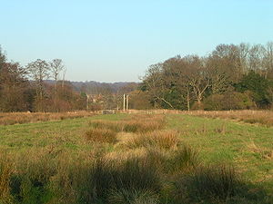
beds, creating a shaded artificial gorge rich in mosses and lichens. Emerging from this cutting at the site of Upper Lock the canal follows a straight course across low lying boggy ground, fenced off as a nature reserve area. Reaching the site of Haines Lock the stream can be heard pouring through a broken down weir in the undergrowth as it turns eastward into its natural course. The west bank of the canal here runs into the pasture for some twenty metres and the position of the levelled course beyond can just be discerned. Beyond the slightly higher ground here, as the Haslingbourne Stream again comes close to the canal, the embankments can be seen forming a straight line across the floodplain
Floodplain
A floodplain, or flood plain, is a flat or nearly flat land adjacent a stream or river that stretches from the banks of its channel to the base of the enclosing valley walls and experiences flooding during periods of high discharge...
to the river. A pond near the river is the site of a weir and tumblebay.