

Phoenix metropolitan area arterial roads
Encyclopedia
Many arterial road
s in the Phoenix metropolitan area
have the same name in multiple cities or towns. Some roads change names or route numbers across town borders, resulting in occasional confusion. For example, the road known as Apache Boulevard in Tempe
continues east as Main Street in neighboring Mesa
and then as Apache Trail in Apache Junction
. Although Broadway Road maintains the same name through Goodyear
, Avondale
, Phoenix
, Tempe, Mesa, and Apache Junction, each town uses a different reference point for address numbers.
for Arizona as given under the Public Land Survey System
.
This line is called the Gila and Salt River Base Line, and runs east-west from the "zero point" atop a hill near the confluence of the Gila and Salt rivers, on Avondale Boulevard (115th Avenue) at Baseline Road. This site is next to Phoenix International Raceway. Avondale Boulevard is laid out atop the north-south base meridian.
Due to natural obstructions, this road is not continuous. The road is located in Maricopa County
and Pinal County
. There is also a rural road named Baseline Road in southern La Paz County
close to the Colorado River
which is located near Arizona's baseline.
Because of the grid plan
used by cities in Arizona, the name for the road is applied for non-contiguous sections and is theoretically reserved for future east-west roads built at the same latitude.
. The route picks up again and runs due westward, running parallel to US 60. At the Maricopa County border, the road enters Mesa and is named Baseline Road. It becomes a major arterial road as it passes through Gilbert
and Tempe. In Tempe, it intersects Loop 101 and then Interstate 10. Continuing, the road runs through south Phoenix and the major arterial segment of the road terminates in the Gila River Indian Community
, approximately where the Salt River
joins the Gila River
.
The road reappears on the other side of the Gila River at an orthogonal junction with Perryville Rd. as CR-85 and continues westward through central Buckeye
. From there, it continues through farmland in western Maricopa county in various non-continuous segments. The segment of Baseline Road furthest west in Maricopa County is just past 547th Avenue.
Due to the ease of navigation on this extremely long route, as well as the significant number of municipalities that the route encompasses, it is a favorite street for those electing not to use Phoenix's many highways such as I-10 and US 60.
and Phoenix International Raceway
. Baseline Road runs through the historical farming community of Laveen
.
is a major east-west arterial road in northern metropolitan Phoenix. Bell Road is one of the few roadways to cross the Agua Fria River in the northern part of the metro area, providing a vital link between the growing suburb of Surprise
with Phoenix. As a result, the portion of Bell Road passing through Surprise and Sun City
is the busiest arterial road in the state of Arizona.
Through North Scottsdale
, the road is named "Frank Lloyd Wright" boulevard in recognition of architect and designer Frank Lloyd Wright
.
, and U.S. Route 60 and State Route 303 in Surprise. West of the Beardsley Canal, the roadway curves around the White Tank Mountain Regional Park
, becoming the Sun Valley Parkway through northern Buckeye
.
A non-contiguous segment of Bell Road approximately 3 miles (4.8 km) long exists in northern Scottsdale, which includes an intersection with the eastern leg of State Route 101.
, Turf Paradise, Arrowhead Towne Center
and the Peoria Sports Complex
. Bell Road also forms the boundary of the original town site of Surprise.
 Camelback Road is a prominent street in the metropolitan area.
The street stretches from Scottsdale in the east to Litchfield Park
in the west, and in the process runs through the city of Phoenix. Scottsdale Fashion Square
is located at the corner of Camelback and Scottsdale Roads.
Camelback Road runs directly south of Phoenix's famous Camelback Mountain
and the Phoenician Resort. Further west, the upscale Biltmore district of Phoenix is located along Camelback Road, including the Arizona Biltmore Hotel
(just to the north), Biltmore Fashion Park
, as well as one of Phoenix's primary business districts (sometimes called the Camelback Corridor).
In Litchfield Park, Camelback Road passes the historic Wigwam Resort, built in 1918.
West of Litchfield Park, Camelback Road skirts the southern boundary of Luke Air Force Base
.
to North Mountain in Phoenix. The Central Avenue Corridor, roughly from Camelback Road to McDowell Road, is one of Phoenix's most heavily trafficked stretches of roadway. The Central Avenue Corridor bisects the area known as Midtown, Phoenix, a collection of neighborhoods north of Downtown and south of the North-Central and Sunnyslope areas.
For the most part, Central Avenue marks the "zero" point of east/west addresses in the Phoenix area.
Lower Grand Avenue between Roosevelt Street on the north and Van Buren on the south is home to numerous cafes, bars, and small businesses in historical and landmark storefront properties lining the street. The Grand Avenue Merchants Association exists to bring the Grand Avenue community together with other neighborhood associations to form a vibrant arts, culture and small business district with a mind towards adaptive reuse
of historical buildings, responsible infill projects and both small business and community based outreach.
at the east end and Buckeye & Maricopa County White Tank Mountain Regional Park at the west end. It intersects with Arizona State Route 51, Arizona State Route 101, Interstate 17
, US 60/Grand Avenue and Arizona State Route 303. Though running predominantly through the metro Phoenix area, Indian School Road does continue west of the White Tank Mountains from approximately 27600 West to 41100 West (411th Avenue being an overpass and access to Tonopah
and Interstate 10
) to 46700 West, and from 48700 West to Harquahala Valley Road (52000 West).
Indian School Road was named in territorial days as the road to the Phoenix Indian School
(1890-1991) located on the site of the present Steele Indian School Park
.
, the street runs through a popular, pedestrian-friendly shopping and nightlife
district. Mill Avenue was originally centered around the Hayden Flour Mill, which, while disused, still stands on the north end of the Avenue. Today, the avenue plays host to many bars
, designer shopping stores, as well as many fairs, and city festivals. It was described in 2010 by a New York Times reporter as "a bohemian
commercial strip next to Arizona State University".
At the northern end of the shopping district, the two Mill Avenue bridges
cross the Salt River
at Tempe Town Lake
. One bridge was completed in 1931, the other in 1994.
 After the founding of Fort McDowell on the east side of central Arizona’s Salt River Valley in 1865, farmers moved into the area. These early settlers further developed the irrigation canals that the Hohokam
people originally created and built new ones to carry Salt River water to their farms. Agriculture in the Salt River valley soon gave food to Arizona’s military
posts and mining towns. In 1871, Hiram C. Hodge commented that there were two stores and a population
of about 100 in Tempe.
A substantial addition to the Tempe economy was established in 1877, when Charles T. Hayden
, a business man from Connecticut
, opened a flour-mill operation that was supplied with water from the Tempe Irrigating Canal. Charles T. Hayden, and his family operated the mill for three full generations, and it was the crucial to Tempe's community industry.
Also in 1877, Charles' son Carl Hayden, who was to become a congressman and then senator from Arizona, was born in the Hayden family home, a building which is still a landmark on Mill Avenue today, now known as the western steakhouse Monti's La Casa Vieja ("The Old House").
 The Hayden's Ferry Post Office
was renamed the Tempe Post Office in 1879. In 1889, the new Phoenix and Maricopa Railroad linked Tempe with Phoenix. In 1894, the Maricopa County Board of Supervisors incorporated the town of Tempe. Tempe finally became a city after being inhabited for over 30 years.
In 1962, the Laird and Dines Drug Store closed after 68 years of operation at the corner of Mill Avenue and Fifth Street. This drug store was one of the original fixtures on the commercial district of Mill Avenue. Tempe’s commercial center along Mill Avenue declined during these years.
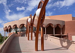
In 1964, construction of the Grady Gammage Memorial Auditorium, designed by Frank Lloyd Wright
, was completed at the intersection of Mill Avenue and Apache Boulevard on the campus of Arizona State University
.
Prompted by Tempe’s centennial in 1971, Mill Avenue was revitalized into an entertainment
and shopping district that attracts people from throughout the Phoenix Valley.
In 1997, the Hayden Flour Mill closed after 123 years of continuous operation. The mill's last operator was Bay State Milling, which had purchased it in 1981. It is significant as the oldest continuously used industrial site in the Salt River Valley.
) is located on Mill Avenue as a comfortable single screen theater that typically shows art house and occasionally foreign films. The current building was built in 1938, although it underwent substantial internal renovations in the 1990s. Harkins Centerpoint, an 11-screen complex, was also located on the avenue for a long time; however, with the completion of the Tempe Marketplace
, which provided a modern Harkins building, it had to close.
Built in the 1980s, the four-lane divided parkway traverses approximately 30 miles of what was once open desert about 35 miles west of downtown Phoenix. It extends north–south from Interstate 10 at exit 109 (Sun Valley Parkway / Palo Verde Road) in Buckeye, turns after about 12 miles or so to become an east–west road, and leads eastward to Surprise, where the road connects to and becomes Bell Road through Surprise and other West Valley suburbs (and eventually the City of Phoenix itself).
and Sun City Festival. Other communities in the planning stages include Sun Valley, Sun Valley South, Spurlock Ranch, Elianto, Trillium in Buckeye and Douglass Ranch in Buckeye.
Arterial road
An arterial road, or arterial thoroughfare, is a high-capacity urban road. The primary function of an arterial road is to deliver traffic from collector roads to freeways, and between urban centres at the highest level of service possible. As such, many arteries are limited-access roads, or feature...
s in the Phoenix metropolitan area
Phoenix Metropolitan Area
The Phoenix metropolitan area, often referred to as The Valley of the Sun, is a metropolitan area, centered on the city of Phoenix, that includes much of the central part of the US state of Arizona...
have the same name in multiple cities or towns. Some roads change names or route numbers across town borders, resulting in occasional confusion. For example, the road known as Apache Boulevard in Tempe
Tempe, Arizona
Tempe is a city in Maricopa County, Arizona, USA, with the Census Bureau reporting a 2010 population of 161,719. The city is named after the Vale of Tempe in Greece. Tempe is located in the East Valley section of metropolitan Phoenix; it is bordered by Phoenix and Guadalupe on the west, Scottsdale...
continues east as Main Street in neighboring Mesa
Mesa, Arizona
According to the 2010 Census, the racial composition of Mesa was as follows:* White: 77.1% * Hispanic or Latino : 26.54%* Black or African American: 3.5%* Two or more races: 3.4%* Native American: 2.4%...
and then as Apache Trail in Apache Junction
Apache Junction, Arizona
Apache Junction is a city in Maricopa and Pinal counties in the U.S. state of Arizona. According to the 2010 Census, the population of the city was 35,840, most of whom lived in Pinal County....
. Although Broadway Road maintains the same name through Goodyear
Goodyear, Arizona
Goodyear is a city in Maricopa County, Arizona, United States. According to the 2010 census, the population of the city is 65,275...
, Avondale
Avondale, Arizona
Avondale is a city in Maricopa County, Arizona, USA, adjacent to Phoenix, Arizona. According to 2010 Census Bureau, the population of the city is 76,238.Avondale is the home of Phoenix International Raceway, an auto racing facility...
, Phoenix
Phoenix, Arizona
Phoenix is the capital, and largest city, of the U.S. state of Arizona, as well as the sixth most populated city in the United States. Phoenix is home to 1,445,632 people according to the official 2010 U.S. Census Bureau data...
, Tempe, Mesa, and Apache Junction, each town uses a different reference point for address numbers.
Baseline Road
Baseline Road is a significant east-west arterial road. This road is so named because it runs along the length of the primary baselineBaseline (surveying)
In the United States Public Land Survey System, a baseline is the principal east-west line that divides survey townships between north and south. The baseline meets its corresponding meridian at the point of origin, or initial point, for the land survey...
for Arizona as given under the Public Land Survey System
Public Land Survey System
The Public Land Survey System is a method used in the United States to survey and identify land parcels, particularly for titles and deeds of rural, wild or undeveloped land. Its basic units of area are the township and section. It is sometimes referred to as the rectangular survey system,...
.
This line is called the Gila and Salt River Base Line, and runs east-west from the "zero point" atop a hill near the confluence of the Gila and Salt rivers, on Avondale Boulevard (115th Avenue) at Baseline Road. This site is next to Phoenix International Raceway. Avondale Boulevard is laid out atop the north-south base meridian.
Due to natural obstructions, this road is not continuous. The road is located in Maricopa County
Maricopa County, Arizona
-2010:Whereas according to the 2010 U.S. Census Bureau:*73.0% White*5.0% Black*2.1% Native American*3.5% Asian*0.2% Native Hawaiian or Pacific Islander*3.5% Two or more races*12.7% Other races*29.6% Hispanic or Latino -2000:...
and Pinal County
Pinal County, Arizona
-2010:Whereas according to the 2010 U.S. Census Bureau:*72.4% White*4.6% Black*5.6% Native American*1.7% Asian*0.4% Native Hawaiian or Pacific Islander*3.8% Two or more races*11.5% Other races*28.5% Hispanic or Latino -2000:...
. There is also a rural road named Baseline Road in southern La Paz County
La Paz County, Arizona
La Paz County is a county in the western part of the U.S. state of Arizona. As of the 2010 census its population was 20,489. The county seat is Parker...
close to the Colorado River
Colorado River
The Colorado River , is a river in the Southwestern United States and northwestern Mexico, approximately long, draining a part of the arid regions on the western slope of the Rocky Mountains. The watershed of the Colorado River covers in parts of seven U.S. states and two Mexican states...
which is located near Arizona's baseline.
Because of the grid plan
Grid plan
The grid plan, grid street plan or gridiron plan is a type of city plan in which streets run at right angles to each other, forming a grid...
used by cities in Arizona, the name for the road is applied for non-contiguous sections and is theoretically reserved for future east-west roads built at the same latitude.
Route description
Starting from east, the road begins in Apache Junction in Pinal County, named Baseline Avenue and is a small segment of thoroughfare in a residential neighborhood at the foothills of the Superstition MountainsSuperstition Mountains
The Superstition Mountains , popularly referred to as "The Superstitions", are a range of mountains in Arizona located to the east of the Phoenix metropolitan area...
. The route picks up again and runs due westward, running parallel to US 60. At the Maricopa County border, the road enters Mesa and is named Baseline Road. It becomes a major arterial road as it passes through Gilbert
Gilbert, Arizona
-Demographics:As of July 1, 2009, Maricopa Association of Governments, Census 2000. United States Census Bureau. there were 217,521 people, 74,147 housing units, and 3.01 persons per household....
and Tempe. In Tempe, it intersects Loop 101 and then Interstate 10. Continuing, the road runs through south Phoenix and the major arterial segment of the road terminates in the Gila River Indian Community
Gila River Indian Community
The Gila River Indian Community is an Indian reservation in the U.S. state of Arizona, lying adjacent to the south side of the city of Phoenix, within the Phoenix Metropolitan Area in Pinal and Maricopa Counties. It was established in 1859, and formally established by Congress in 1939...
, approximately where the Salt River
Salt River (Arizona)
The Salt River is a stream in the U.S. state of Arizona. It is the largest tributary of the Gila River. The river is about long. Its drainage basin is about large. The longest of the Salt River's many tributaries is the Verde River...
joins the Gila River
Gila River
The Gila River is a tributary of the Colorado River, 650 miles long, in the southwestern states of New Mexico and Arizona.-Description:...
.
The road reappears on the other side of the Gila River at an orthogonal junction with Perryville Rd. as CR-85 and continues westward through central Buckeye
Buckeye, Arizona
Buckeye is a town in Maricopa County, Arizona, United States and is the westernmost suburb in the Phoenix metropolitan area. The population of the town as of Census 2010 was 50,876, a 678% increase from the 2000 population of 6,537.-Geography:...
. From there, it continues through farmland in western Maricopa county in various non-continuous segments. The segment of Baseline Road furthest west in Maricopa County is just past 547th Avenue.
Due to the ease of navigation on this extremely long route, as well as the significant number of municipalities that the route encompasses, it is a favorite street for those electing not to use Phoenix's many highways such as I-10 and US 60.
Landmarks
Notable locations along or near Baseline Road include Arizona MillsArizona Mills
Arizona Mills is an indoor outlet mall in Tempe, Arizona. It is mostly owned by Simon Property Group and managed by The Taubman Company. It opened on November 20, 1997, with 6,000 parking spaces and approximately 200 retailers. It is currently anchored by outlet versions of Saks Fifth Avenue,...
and Phoenix International Raceway
Phoenix International Raceway
Phoenix International Raceway, also known as PIR, is a one-mile, low-banked tri-oval race track located in Avondale, Arizona. The track opened in 1964 and currently hosts two NASCAR race weekends annually. PIR has also hosted the Indycar Series, CART, USAC and the Rolex Sports Car Series...
. Baseline Road runs through the historical farming community of Laveen
Laveen, Arizona
Laveen is a suburban community in Maricopa County, Arizona, United States, situated eight miles southwest of Downtown Phoenix near the confluence of the Gila and Salt rivers. Parts of Laveen constitute an unincorporated area in Maricopa County, while the remainder falls within the city limits of...
.
Bell Road
Bell RoadBell Road (Phoenix Metro)
Bell Road is a major east-west arterial road in northern metropolitan Phoenix, Arizona, United States. Bell Road is one of the few roadways to cross the Agua Fria River in the northern part of the metro area, providing a vital link between the growing suburb of Surprise with Phoenix...
is a major east-west arterial road in northern metropolitan Phoenix. Bell Road is one of the few roadways to cross the Agua Fria River in the northern part of the metro area, providing a vital link between the growing suburb of Surprise
Surprise, Arizona
Surprise is a city in Maricopa County, Arizona, USA. The population was 30,848 at the 2000 census; however, rapid growth has boosted the city's population to 117,517 at the 2010 census, an increase of 281%...
with Phoenix. As a result, the portion of Bell Road passing through Surprise and Sun City
Sun City, Arizona
Sun City is a census-designated place and unincorporated town in Maricopa County, Arizona, United States. The population was 38,309 at the 2000 census...
is the busiest arterial road in the state of Arizona.
Through North Scottsdale
Scottsdale, Arizona
Scottsdale is a city in the eastern part of Maricopa County, Arizona, United States, adjacent to Phoenix. According to the U.S. Census Bureau, as of 2010 the population of the city was 217,385...
, the road is named "Frank Lloyd Wright" boulevard in recognition of architect and designer Frank Lloyd Wright
Frank Lloyd Wright
Frank Lloyd Wright was an American architect, interior designer, writer and educator, who designed more than 1,000 structures and completed 500 works. Wright believed in designing structures which were in harmony with humanity and its environment, a philosophy he called organic architecture...
.
Route description
The main segment of Bell Road, approximately 31 miles (49.9 km) in length, begins at the corporate boundaries of Phoenix and Scottsdale at its intersection with Scottsdale Road; east of Scottsdale Road, the roadway curves to the southeast and becomes Frank Lloyd Wright Boulevard. Traveling west, the road intersects with State Route 51 and Interstate 17 in Phoenix, the western leg of State Route 101 in PeoriaPeoria, Arizona
Peoria is a city in Maricopa and Yavapai counties in the U.S. state of Arizona. Located primarily in Maricopa County, it is a major suburb of Phoenix. According to 2010 Census Bureau releases, the population of the city is 154,065. Peoria is currently the sixth largest city in Arizona for land...
, and U.S. Route 60 and State Route 303 in Surprise. West of the Beardsley Canal, the roadway curves around the White Tank Mountain Regional Park
White Tank Mountain Regional Park
The White Tank Mountain Regional Park is a large regional park located in west-central Maricopa County, Arizona. Encompassing of desert and mountain landscape, it is the largest regional park in the county...
, becoming the Sun Valley Parkway through northern Buckeye
Buckeye, Arizona
Buckeye is a town in Maricopa County, Arizona, United States and is the westernmost suburb in the Phoenix metropolitan area. The population of the town as of Census 2010 was 50,876, a 678% increase from the 2000 population of 6,537.-Geography:...
.
A non-contiguous segment of Bell Road approximately 3 miles (4.8 km) long exists in northern Scottsdale, which includes an intersection with the eastern leg of State Route 101.
Landmarks
Prominent locations on or near Bell Road include the Scottsdale Municipal AirportScottsdale Airport
Scottsdale Airport is a city-owned public-use airport located nine miles north of the central business district of Scottsdale, a city in Maricopa County, Arizona, United States. Although most U.S...
, Turf Paradise, Arrowhead Towne Center
Arrowhead Towne Center
Arrowhead Towne Center is a regional enclosed shopping mall located in Glendale, Arizona. The mall is managed by Westcor. It is anchored by Macy's, Sears, Dillard's, JCPenney, and AMC Theatres. It is currently the only enclosed shopping mall in the West Valley suburbs of Phoenix, though several new...
and the Peoria Sports Complex
Peoria Sports Complex
The Peoria Sports Complex is a baseball complex located in Peoria, Arizona, near Peoria's main shopping district on Bell Road. It consists of the main baseball stadium and twelve practice fields. It is one of five facilities to host Arizona Fall League games...
. Bell Road also forms the boundary of the original town site of Surprise.
Camelback Road
The street stretches from Scottsdale in the east to Litchfield Park
Litchfield Park, Arizona
Litchfield Park is a city in Maricopa County, Arizona, United States. In 2010 it had a population of 5,476.-History:The town of Litchfield Park is named for its founder, Paul Weeks Litchfield...
in the west, and in the process runs through the city of Phoenix. Scottsdale Fashion Square
Scottsdale Fashion Square
Scottsdale Fashion Square is the largest shopping mall in Arizona and the American Southwest, with approximately 2 million square feet of retail space, and is among the top 30 largest malls in the country. It is one of the top 10 most profitable malls in the country with over $740 sales per square...
is located at the corner of Camelback and Scottsdale Roads.
Camelback Road runs directly south of Phoenix's famous Camelback Mountain
Camelback Mountain
Camelback Mountain is a mountain in Phoenix, Arizona, United States. The name is derived from its shape, which resembles the hump and head of a kneeling camel. The mountain, a prominent landmark for the metropolitan Phoenix valley, is located in the Camelback Mountain Echo Canyon Recreation Area...
and the Phoenician Resort. Further west, the upscale Biltmore district of Phoenix is located along Camelback Road, including the Arizona Biltmore Hotel
Arizona Biltmore Hotel
The Arizona Biltmore Hotel is a resort located in Phoenix near 24th Street and Camelback Road. It recently joined the Hilton Hotels' luxury collection The Waldorf-Astoria Collection and was also featured on the Travel Channel show Great Hotels....
(just to the north), Biltmore Fashion Park
Biltmore Fashion Park
The Biltmore Fashion Park is a luxury outdoor retail and dining plaza located in the Biltmore District of Phoenix, Arizona, along the prestigious stretch of East Camelback Rd. The recently renovated and expanded mid-century plaza is the city of Phoenix's premiere address for high-end retail...
, as well as one of Phoenix's primary business districts (sometimes called the Camelback Corridor).
In Litchfield Park, Camelback Road passes the historic Wigwam Resort, built in 1918.
West of Litchfield Park, Camelback Road skirts the southern boundary of Luke Air Force Base
Luke Air Force Base
Luke Air Force Base is a United States Air Force base located seven miles west of the central business district of Glendale, in Maricopa County, Arizona, United States. It is also about west of Phoenix, Arizona....
.
Central Avenue
Central Avenue extends from South Mountain ParkSouth Mountain Park
South Mountain Park in Phoenix, Arizona, is the largest city park in the United States, one of the largest urban parks in North America and in the world. It has been designated as a Phoenix Point of Pride.-Geography and Ecology:...
to North Mountain in Phoenix. The Central Avenue Corridor, roughly from Camelback Road to McDowell Road, is one of Phoenix's most heavily trafficked stretches of roadway. The Central Avenue Corridor bisects the area known as Midtown, Phoenix, a collection of neighborhoods north of Downtown and south of the North-Central and Sunnyslope areas.
For the most part, Central Avenue marks the "zero" point of east/west addresses in the Phoenix area.
Grand Avenue
The portion of U.S. Route 60 that passes through Phoenix is known as Grand Avenue. Grand Avenue slices through west Phoenix at a 45-degree angle, making it instantly recognizable on any City of Phoenix map, and represents the final leg of US 60 into the heart of Phoenix.Lower Grand Avenue between Roosevelt Street on the north and Van Buren on the south is home to numerous cafes, bars, and small businesses in historical and landmark storefront properties lining the street. The Grand Avenue Merchants Association exists to bring the Grand Avenue community together with other neighborhood associations to form a vibrant arts, culture and small business district with a mind towards adaptive reuse
Adaptive reuse
Adaptive reuse refers to the process of reusing an old site or building for a purpose other than which it was built or designed for. Along with brownfield reclamation, adaptive reuse is seen by many as a key factor in land conservation and the reduction of urban sprawl...
of historical buildings, responsible infill projects and both small business and community based outreach.
Indian School Road
Indian School Road runs east/west with the Salt River Pima-Maricopa Indian CommunitySalt River Pima-Maricopa Indian Community
The Salt River Pima–Maricopa Indian Community comprises two distinct Native American tribes—the Pima and the Maricopa —many of whom were originally of the Halchidhoma tribe. The community was officially created by an Executive Order of US President Rutherford B. Hayes on June 14, 1879...
at the east end and Buckeye & Maricopa County White Tank Mountain Regional Park at the west end. It intersects with Arizona State Route 51, Arizona State Route 101, Interstate 17
Interstate 17
Interstate 17 , also known as the Black Canyon Freeway, is an intrastate Interstate Highway located entirely within the state of Arizona, United States. I-17's southern terminus lies within Phoenix, at Interstate 10, and its northern terminus is in Flagstaff, at Interstate 40...
, US 60/Grand Avenue and Arizona State Route 303. Though running predominantly through the metro Phoenix area, Indian School Road does continue west of the White Tank Mountains from approximately 27600 West to 41100 West (411th Avenue being an overpass and access to Tonopah
Tonopah, Arizona
Tonopah is a census-designated place in western Maricopa County, Arizona, United States, approximately 50 miles west of downtown Phoenix off Interstate 10...
and Interstate 10
Interstate 10
Interstate 10 is the fourth-longest Interstate Highway in the United States, after I-90, I-80, and I-40. It is the southernmost east–west, coast-to-coast Interstate Highway, although I-4 and I-8 are further south. It stretches from the Pacific Ocean at State Route 1 in Santa Monica,...
) to 46700 West, and from 48700 West to Harquahala Valley Road (52000 West).
Indian School Road was named in territorial days as the road to the Phoenix Indian School
Phoenix Indian School
The Phoenix Indian School, or Phoenix Indian High School in its later years, was a Bureau of Indian Affairs-operated school in the heart of Phoenix, Arizona. It was mostly a high school, but it served lower grades from 1891 to 1935. It opened in 1891 and closed in 1990 at the orders of the federal...
(1890-1991) located on the site of the present Steele Indian School Park
Steele Indian School Park
Steele Indian School Park is located on the northeast corner of Indian School Road and Central Avenue in Phoenix, Arizona.The park is on the site of the Phoenix Indian School, one of several boarding schools owned and operated by the U.S. government, designed in the late 19th century to socialize...
.
Landmarks
- Arcadia High School 4703 East. Past students include Steven SpielbergSteven SpielbergSteven Allan Spielberg KBE is an American film director, screenwriter, producer, video game designer, and studio entrepreneur. In a career of more than four decades, Spielberg's films have covered many themes and genres. Spielberg's early science-fiction and adventure films were seen as an...
, Linda Carter and Astronaut Bill ShepherdWilliam ShepherdWilliam McMichael Shepherd is a former American astronaut who served as commander of Expedition 1, the first crew on the International Space Station. Shepherd is a recipient of the Congressional Space Medal of Honor.-Biography:...
. - Carl Hayden Veterans Administration Medical Center, 650 East, named after Arizona's first Representative (1912-1927) and US Senator from Arizona (1927-1969) succeeded by Barry Goldwater.
- Steele Indian School Park, 300 East. Original site of the Phoenix Indian SchoolPhoenix Indian SchoolThe Phoenix Indian School, or Phoenix Indian High School in its later years, was a Bureau of Indian Affairs-operated school in the heart of Phoenix, Arizona. It was mostly a high school, but it served lower grades from 1891 to 1935. It opened in 1891 and closed in 1990 at the orders of the federal...
; there are historical buildings that were once part of the Indian School campus, specifically the Dining Hall, built in 1902, and Memorial Hall, built in 1922. More recently, this was the site of a helicopter crash on July 27, 2007 when KTVKKTVKKTVK is a full-service, independent television station in Phoenix, Arizona. It broadcasts in digital on UHF channel 24 from a transmitter located on South Mountain in Phoenix, and can be seen across northern Arizona on a network of nearly two dozen translator stations...
and KNXV choppers collided during a police chase, and wreckage landed in the park. - Phoenix Air Haven Airport, 2700-3300 West, was located on the south side of the road from 1945 to 1960. It is now an industrial office complex.
- Maryvale MallMaryvale MallMaryvale Mall was the second shopping mall in Phoenix, Arizona, before being redeveloped, it was located on 51st Avenue and Indian School Road. Today it exists partially as a Middle School, Elementary School and Police Station...
5100 West. Now closed, the site consists of two schools (an elementary and a middle) utilizing former buildings of the mall. A nearby Super Wal-mart was built with a new structure.
Mill Avenue
Mill Avenue is a historic street in Tempe. In north Tempe near Arizona State UniversityArizona State University
Arizona State University is a public research university located in the Phoenix Metropolitan Area of the State of Arizona...
, the street runs through a popular, pedestrian-friendly shopping and nightlife
Nightlife
Nightlife is the collective term for any entertainment that is available and more popular from the late evening into the early hours of the morning...
district. Mill Avenue was originally centered around the Hayden Flour Mill, which, while disused, still stands on the north end of the Avenue. Today, the avenue plays host to many bars
Bar (establishment)
A bar is a business establishment that serves alcoholic drinks — beer, wine, liquor, and cocktails — for consumption on the premises.Bars provide stools or chairs that are placed at tables or counters for their patrons. Some bars have entertainment on a stage, such as a live band, comedians, go-go...
, designer shopping stores, as well as many fairs, and city festivals. It was described in 2010 by a New York Times reporter as "a bohemian
Bohemianism
Bohemianism is the practice of an unconventional lifestyle, often in the company of like-minded people, with few permanent ties, involving musical, artistic or literary pursuits...
commercial strip next to Arizona State University".
At the northern end of the shopping district, the two Mill Avenue bridges
Mill Avenue Bridges
The Mill Avenue Bridges consist of two bridges that cross the Salt River in Tempe, Arizona at the north end of the shopping district on Mill Avenue. The first bridge opened in August 1931 and the second bridge opened in 1994.-Original Span:...
cross the Salt River
Salt River (Arizona)
The Salt River is a stream in the U.S. state of Arizona. It is the largest tributary of the Gila River. The river is about long. Its drainage basin is about large. The longest of the Salt River's many tributaries is the Verde River...
at Tempe Town Lake
Tempe Town Lake
Tempe Town Lake is a reservoir that occupies a portion of the currently dry riverbed of the Salt River as it passes through the city of Tempe, Arizona just north of Tempe Butte....
. One bridge was completed in 1931, the other in 1994.
History
Hohokam
Hohokam is one of the four major prehistoric archaeological Oasisamerica traditions of what is now the American Southwest. Many local residents put the accent on the first syllable . Variant spellings in current, official usage include Hobokam, Huhugam and Huhukam...
people originally created and built new ones to carry Salt River water to their farms. Agriculture in the Salt River valley soon gave food to Arizona’s military
Military
A military is an organization authorized by its greater society to use lethal force, usually including use of weapons, in defending its country by combating actual or perceived threats. The military may have additional functions of use to its greater society, such as advancing a political agenda e.g...
posts and mining towns. In 1871, Hiram C. Hodge commented that there were two stores and a population
Population
A population is all the organisms that both belong to the same group or species and live in the same geographical area. The area that is used to define a sexual population is such that inter-breeding is possible between any pair within the area and more probable than cross-breeding with individuals...
of about 100 in Tempe.
A substantial addition to the Tempe economy was established in 1877, when Charles T. Hayden
Charles T. Hayden
Charles Trumbull Hayden was an American businessman and probate judge. His influence was felt in the development of Arizona Territory where he helped found both the city of Tempe and Arizona State University. Hayden is also known as the father of U.S...
, a business man from Connecticut
Connecticut
Connecticut is a state in the New England region of the northeastern United States. It is bordered by Rhode Island to the east, Massachusetts to the north, and the state of New York to the west and the south .Connecticut is named for the Connecticut River, the major U.S. river that approximately...
, opened a flour-mill operation that was supplied with water from the Tempe Irrigating Canal. Charles T. Hayden, and his family operated the mill for three full generations, and it was the crucial to Tempe's community industry.
Also in 1877, Charles' son Carl Hayden, who was to become a congressman and then senator from Arizona, was born in the Hayden family home, a building which is still a landmark on Mill Avenue today, now known as the western steakhouse Monti's La Casa Vieja ("The Old House").
Post office
A post office is a facility forming part of a postal system for the posting, receipt, sorting, handling, transmission or delivery of mail.Post offices offer mail-related services such as post office boxes, postage and packaging supplies...
was renamed the Tempe Post Office in 1879. In 1889, the new Phoenix and Maricopa Railroad linked Tempe with Phoenix. In 1894, the Maricopa County Board of Supervisors incorporated the town of Tempe. Tempe finally became a city after being inhabited for over 30 years.
In 1962, the Laird and Dines Drug Store closed after 68 years of operation at the corner of Mill Avenue and Fifth Street. This drug store was one of the original fixtures on the commercial district of Mill Avenue. Tempe’s commercial center along Mill Avenue declined during these years.
In 1964, construction of the Grady Gammage Memorial Auditorium, designed by Frank Lloyd Wright
Frank Lloyd Wright
Frank Lloyd Wright was an American architect, interior designer, writer and educator, who designed more than 1,000 structures and completed 500 works. Wright believed in designing structures which were in harmony with humanity and its environment, a philosophy he called organic architecture...
, was completed at the intersection of Mill Avenue and Apache Boulevard on the campus of Arizona State University
Arizona State University
Arizona State University is a public research university located in the Phoenix Metropolitan Area of the State of Arizona...
.
Prompted by Tempe’s centennial in 1971, Mill Avenue was revitalized into an entertainment
Entertainment
Entertainment consists of any activity which provides a diversion or permits people to amuse themselves in their leisure time. Entertainment is generally passive, such as watching opera or a movie. Active forms of amusement, such as sports, are more often considered to be recreation...
and shopping district that attracts people from throughout the Phoenix Valley.
In 1997, the Hayden Flour Mill closed after 123 years of continuous operation. The mill's last operator was Bay State Milling, which had purchased it in 1981. It is significant as the oldest continuously used industrial site in the Salt River Valley.
Theaters
The Valley Art Theater (operated by Harkins TheatresHarkins Theatres
Harkins Theatres is a movie theater chain with locations throughout the Southwestern United States. Harkins Theatres is privately owned and operated by its parent company, Harkins Enterprises, LLC...
) is located on Mill Avenue as a comfortable single screen theater that typically shows art house and occasionally foreign films. The current building was built in 1938, although it underwent substantial internal renovations in the 1990s. Harkins Centerpoint, an 11-screen complex, was also located on the avenue for a long time; however, with the completion of the Tempe Marketplace
Tempe Marketplace
Tempe Marketplace is an open air shopping center located in Tempe, Arizona. It is located along the Salt River near the interchange of the Loop 101 Pima/Price Freeway and Loop 202 Red Mountain Freeway near the Tempe borders with Mesa and the Salt River Pima-Maricopa Indian Community.- History :The...
, which provided a modern Harkins building, it had to close.
Sun Valley Parkway
Sun Valley Parkway is mainly located in Buckeye, with a small portion extending into Surprise, Arizona.Built in the 1980s, the four-lane divided parkway traverses approximately 30 miles of what was once open desert about 35 miles west of downtown Phoenix. It extends north–south from Interstate 10 at exit 109 (Sun Valley Parkway / Palo Verde Road) in Buckeye, turns after about 12 miles or so to become an east–west road, and leads eastward to Surprise, where the road connects to and becomes Bell Road through Surprise and other West Valley suburbs (and eventually the City of Phoenix itself).
Developments
There are a number of master-planned communities located along this roadway in Buckeye (after no development in the area for several years after the road was built). Currently being built are TartessoTartesso
Tartesso is a 49,000 residential units master planned community located off Sun Valley Parkway. Tartesso is the third largest development in Buckeye, Arizona.- Tartesso plan :...
and Sun City Festival. Other communities in the planning stages include Sun Valley, Sun Valley South, Spurlock Ranch, Elianto, Trillium in Buckeye and Douglass Ranch in Buckeye.