.gif)
Pichincha (volcano)
Encyclopedia
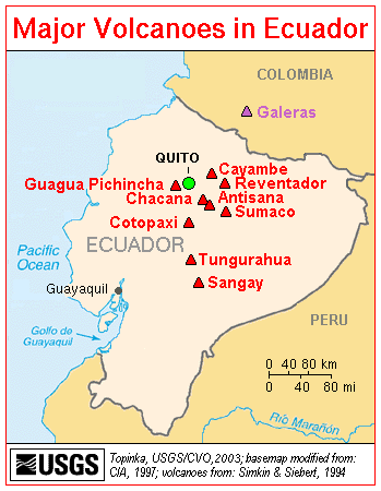
Pichincha is an active stratovolcano
in the country of Ecuador
, whose capital Quito
wraps around its eastern slopes. The mountain's two highest peaks are the Guagua (4784 metres (15,696 ft)), which means "child" in Quechua
and the Rucu (4698 metres (15,413 ft)), which means "old person". The active caldera
is in the Guagua, on the western side of the mountain.
Both peaks are visible from the city of Quito
and are easily climbed. Guagua is usually accessed from the village Lloa outside of Quito. In October 1999, the volcano erupted and covered the city with several inches of ash
. Prior to that, the last major eruptions were in 1553 and in 1660, when about 30 cm of ash fell on the city.
The province
in which it is located takes its name from the mountain, as is the case for many of the other provinces in Ecuador (Cotopaxi
, Chimborazo
, Imbabura
, etc.). On 24 May 1822, in the context of the war of independence of Latin American, Patriot forces defeated a Spanish colonial army on the slopes of the Pichincha. The encounter, known as the Battle of Pichincha
, sealed the independence of the lands that constitute modern Ecuador.

Stratovolcano
A stratovolcano, also known as a composite volcano, is a tall, conical volcano built up by many layers of hardened lava, tephra, pumice, and volcanic ash. Unlike shield volcanoes, stratovolcanoes are characterized by a steep profile and periodic, explosive eruptions...
in the country of Ecuador
Ecuador
Ecuador , officially the Republic of Ecuador is a representative democratic republic in South America, bordered by Colombia on the north, Peru on the east and south, and by the Pacific Ocean to the west. It is one of only two countries in South America, along with Chile, that do not have a border...
, whose capital Quito
Quito
San Francisco de Quito, most often called Quito , is the capital city of Ecuador in northwestern South America. It is located in north-central Ecuador in the Guayllabamba river basin, on the eastern slopes of Pichincha, an active stratovolcano in the Andes mountains...
wraps around its eastern slopes. The mountain's two highest peaks are the Guagua (4784 metres (15,696 ft)), which means "child" in Quechua
Quechua languages
Quechua is a Native South American language family and dialect cluster spoken primarily in the Andes of South America, derived from an original common ancestor language, Proto-Quechua. It is the most widely spoken language family of the indigenous peoples of the Americas, with a total of probably...
and the Rucu (4698 metres (15,413 ft)), which means "old person". The active caldera
Caldera
A caldera is a cauldron-like volcanic feature usually formed by the collapse of land following a volcanic eruption, such as the one at Yellowstone National Park in the US. They are sometimes confused with volcanic craters...
is in the Guagua, on the western side of the mountain.
Both peaks are visible from the city of Quito
Quito
San Francisco de Quito, most often called Quito , is the capital city of Ecuador in northwestern South America. It is located in north-central Ecuador in the Guayllabamba river basin, on the eastern slopes of Pichincha, an active stratovolcano in the Andes mountains...
and are easily climbed. Guagua is usually accessed from the village Lloa outside of Quito. In October 1999, the volcano erupted and covered the city with several inches of ash
Volcanic ash
Volcanic ash consists of small tephra, which are bits of pulverized rock and glass created by volcanic eruptions, less than in diameter. There are three mechanisms of volcanic ash formation: gas release under decompression causing magmatic eruptions; thermal contraction from chilling on contact...
. Prior to that, the last major eruptions were in 1553 and in 1660, when about 30 cm of ash fell on the city.
The province
Pichincha Province
Pichincha is a province of Ecuador located in the northern sierra region; its capital and largest city is Quito. It is bordered by Imbabura & Esmeraldas to the north, Cotopaxi & Santo Domingo de los Tsáchilas to the south, Napo & Sucumbíos to the east, and Esmeraldas & Santo Domingo de los...
in which it is located takes its name from the mountain, as is the case for many of the other provinces in Ecuador (Cotopaxi
Cotopaxi Province
Cotopaxi is one of the provinces of Ecuador. The capital is Latacunga. The province contains the Cotopaxi Volcano, an intermittent volcano with a height of 19,388 feet.- Cantons :The province is divided into 7 cantons...
, Chimborazo
Chimborazo Province
Chimborazo is a province in Ecuador, located in the central Ecuadorian Andes, containing a section of Sangay National Park. The capital is Riobamba. The province contains Chimborazo , Ecuador's highest mountain.- Cantons :...
, Imbabura
Imbabura Province
Imbabura is a province in Ecuador. The capital is Ibarra. The people of the province speak Spanish and the Imbaburan Quechua language.Imbabura Volcano is located in the province. Best reached from the town of La Esperanza, the 4,609-meter-high mountain can be climbed in a single day.- Cantons...
, etc.). On 24 May 1822, in the context of the war of independence of Latin American, Patriot forces defeated a Spanish colonial army on the slopes of the Pichincha. The encounter, known as the Battle of Pichincha
Battle of Pichincha
The Battle of Pichincha took place on 24 May 1822, on the slopes of the Pichincha volcano, 3,500 meters above sea-level, right next to the city of Quito, in modern Ecuador....
, sealed the independence of the lands that constitute modern Ecuador.

External links
- http://www.igepn.edu.ec/vulcanologia/pichincha/pichincha.htm
- CVO Website - Ecuador Volcanoes and Volcanics
- Photographs of the Andes
- "Eruptions of Guagua Pichincha (1999)" NOAA Operational Significant Event Imagery

