

Pine County, Minnesota
Encyclopedia
As of the census
of 2000, there were 26,530 people, 9,939 households, and 6,917 families residing in the county. The population density
was 19 people per square mile (7/km²). There were 15,353 housing units at an average density of 11 per square mile (4/km²). The racial makeup of the county was 91.9% White
, 2.0% Black
or African American
, 3.1% Native American
, 0.30% Asian
, 0.03% Pacific Islander
, 0.4% from other races
, and 1.9% from two or more races. 2.4% of the population were Hispanic
or Latino
of any race. 32.3% were of German, 11.6% Swedish, 11.1% Norwegian and 5.5% American
ancestry according to Census 2000.
 There were 17,276 households out of which 31.20% had children under the age of 18 living with them, 56.50% were married couples
living together, 8.70% had a female householder with no husband present, and 30.40% were non-families. 25.10% of all households were made up of individuals and 10.90% had someone living alone who was 65 years of age or older. The average household size was 2.53 and the average family size was 3.02.
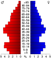
In the county the population was spread out with 25.50% under the age of 18, 7.70% from 18 to 24, 27.90% from 25 to 44, 23.90% from 45 to 64, and 15.00% who were 65 years of age or older. The median age was 38 years. For every 100 females there were 108.80 males. For every 100 females age 18 and over, there were 108.30 males.
The median income for a household in the county was $37,379, and the median income for a family was $44,058. Males had a median income of $31,600 versus $22,675 for females. The per capita income
for the county was $17,445. About 7.80% of families and 11.30% of the population were below the poverty line, including 14.60% of those under age 18 and 10.00% of those age 65 or over.
 Pine County was organized on March 1, 1856, with Chisago County being its primary parent county. Other portions of the original Pine County originated from Ramsey County
. The original county seat was Chengwatana
.
In 1857, Buchanan County
in full and southern portions of Aitkin and Carlton
counties were formed from the original Pine County, with Kanabec County organized a year later. In 1861, Buchanan County was dissolved and folded into Pine County. Pine County was re-organized in 1872, with Pine City
becoming the new county seat.
Census
A census is the procedure of systematically acquiring and recording information about the members of a given population. It is a regularly occurring and official count of a particular population. The term is used mostly in connection with national population and housing censuses; other common...
of 2000, there were 26,530 people, 9,939 households, and 6,917 families residing in the county. The population density
Population density
Population density is a measurement of population per unit area or unit volume. It is frequently applied to living organisms, and particularly to humans...
was 19 people per square mile (7/km²). There were 15,353 housing units at an average density of 11 per square mile (4/km²). The racial makeup of the county was 91.9% White
Race (United States Census)
Race and ethnicity in the United States Census, as defined by the Federal Office of Management and Budget and the United States Census Bureau, are self-identification data items in which residents choose the race or races with which they most closely identify, and indicate whether or not they are...
, 2.0% Black
Race (United States Census)
Race and ethnicity in the United States Census, as defined by the Federal Office of Management and Budget and the United States Census Bureau, are self-identification data items in which residents choose the race or races with which they most closely identify, and indicate whether or not they are...
or African American
Race (United States Census)
Race and ethnicity in the United States Census, as defined by the Federal Office of Management and Budget and the United States Census Bureau, are self-identification data items in which residents choose the race or races with which they most closely identify, and indicate whether or not they are...
, 3.1% Native American
Race (United States Census)
Race and ethnicity in the United States Census, as defined by the Federal Office of Management and Budget and the United States Census Bureau, are self-identification data items in which residents choose the race or races with which they most closely identify, and indicate whether or not they are...
, 0.30% Asian
Race (United States Census)
Race and ethnicity in the United States Census, as defined by the Federal Office of Management and Budget and the United States Census Bureau, are self-identification data items in which residents choose the race or races with which they most closely identify, and indicate whether or not they are...
, 0.03% Pacific Islander
Race (United States Census)
Race and ethnicity in the United States Census, as defined by the Federal Office of Management and Budget and the United States Census Bureau, are self-identification data items in which residents choose the race or races with which they most closely identify, and indicate whether or not they are...
, 0.4% from other races
Race (United States Census)
Race and ethnicity in the United States Census, as defined by the Federal Office of Management and Budget and the United States Census Bureau, are self-identification data items in which residents choose the race or races with which they most closely identify, and indicate whether or not they are...
, and 1.9% from two or more races. 2.4% of the population were Hispanic
Race (United States Census)
Race and ethnicity in the United States Census, as defined by the Federal Office of Management and Budget and the United States Census Bureau, are self-identification data items in which residents choose the race or races with which they most closely identify, and indicate whether or not they are...
or Latino
Race (United States Census)
Race and ethnicity in the United States Census, as defined by the Federal Office of Management and Budget and the United States Census Bureau, are self-identification data items in which residents choose the race or races with which they most closely identify, and indicate whether or not they are...
of any race. 32.3% were of German, 11.6% Swedish, 11.1% Norwegian and 5.5% American
United States
The United States of America is a federal constitutional republic comprising fifty states and a federal district...
ancestry according to Census 2000.
Marriage
Marriage is a social union or legal contract between people that creates kinship. It is an institution in which interpersonal relationships, usually intimate and sexual, are acknowledged in a variety of ways, depending on the culture or subculture in which it is found...
living together, 8.70% had a female householder with no husband present, and 30.40% were non-families. 25.10% of all households were made up of individuals and 10.90% had someone living alone who was 65 years of age or older. The average household size was 2.53 and the average family size was 3.02.
In the county the population was spread out with 25.50% under the age of 18, 7.70% from 18 to 24, 27.90% from 25 to 44, 23.90% from 45 to 64, and 15.00% who were 65 years of age or older. The median age was 38 years. For every 100 females there were 108.80 males. For every 100 females age 18 and over, there were 108.30 males.
The median income for a household in the county was $37,379, and the median income for a family was $44,058. Males had a median income of $31,600 versus $22,675 for females. The per capita income
Per capita income
Per capita income or income per person is a measure of mean income within an economic aggregate, such as a country or city. It is calculated by taking a measure of all sources of income in the aggregate and dividing it by the total population...
for the county was $17,445. About 7.80% of families and 11.30% of the population were below the poverty line, including 14.60% of those under age 18 and 10.00% of those age 65 or over.
History
Ramsey County, Minnesota
Ramsey County is a county located in the U.S. state of Minnesota, founded in 1849. As of 2010, the population was 508,640. Its county seat is St. Paul, which is also Minnesota's state capital. The county is named for Alexander Ramsey , the first governor of the Minnesota Territory...
. The original county seat was Chengwatana
Chengwatana, Minnesota
Chengwatana was an Ojibwa village, located along the lower course of the Snake River, Minnesota. Its name in Ojibwe was Zhingwaadena, a contraction of Zhingwaak-oodena or "White-Pine Town"; English uses the French transcription of the Ojibwe...
.
In 1857, Buchanan County
Buchanan County, Minnesota
Buchanan County is a former county in the U.S. state of Minnesota. It was established May 23, 1857, as a county in the Minnesota Territory, named after President James Buchanan. It comprised the 24 northern townships, now forming the northern half of Pine County, Minnesota. The Buchanan County...
in full and southern portions of Aitkin and Carlton
Carlton County, Minnesota
As of the census of 2000, there were 31,671 people, 12,064 households, and 8,408 families residing in the county. The population density was 37 people per square mile . There were 13,721 housing units at an average density of 16 per square mile...
counties were formed from the original Pine County, with Kanabec County organized a year later. In 1861, Buchanan County was dissolved and folded into Pine County. Pine County was re-organized in 1872, with Pine City
Pine City, Minnesota
Pine City is a city in Pine County, Minnesota, United States. The population was 3,123 at the 2010 census. Pine City is the county seat of, and the largest city in, Pine County...
becoming the new county seat.
Cities and towns
| Cities | Townships | Unincorporated Places | Ghost towns | |
|---|---|---|---|---|
|
Clover Township, Pine County, Minnesota Clover Township is a township in Pine County, Minnesota, United States. The population was 316 at the 2000 census.-Geography:According to the United States Census Bureau, the township has a total area of , of which, of it is land and of it is water.-Demographics:As of the census of 2000, there... Fleming Township, Pine County, Minnesota Fleming Township is a township in Pine County, Minnesota, United States. The population was 115 at the 2000 census.-Geography:According to the United States Census Bureau, the township has a total area of , of which, of it is land and of it is water.-Demographics:As of the census of 2000, there... |
Norman Township, Pine County, Minnesota Norman Township is a township in Pine County, Minnesota, United States. The population was 247 at the 2000 census.-Geography:According to the United States Census Bureau, the township has a total area of 35.9 square miles , of which, 35.7 square miles of it is land and 0.2 square... Pine Lake Township, Pine County, Minnesota Pine Lake Township is a township in Pine County, Minnesota, United States. The population was 576 at the 2000 census.-Geography:According to the United States Census Bureau, the township has a total area of 35.1 square miles , of which, 33.1 square miles of it is land and 2.0 square... |
Beroun, Minnesota Beroun is a small unincorporated community in Pine County, Minnesota, United States.Interstate 35 and County Roads 14 and 61 are three of the main routes in the community... Cloverdale, Minnesota Cloverdale, originally founded as Turpville, is a small unincorporated community in Pine County, Minnesota, United States.Minnesota State Highway 48 and County Road 21 are two of the main routes in the community.... Cloverton, Minnesota Cloverton is an unincorporated community in Pine County, Minnesota, United States. Cloverton is located in New Dosey Township near the Wisconsin state line, east of Sandstone. According to the Minnesota Department of Transportation, Cloverton has an estimated population of 60... Duquette, Minnesota Duquette is a small unincorporated community in Pine County, Minnesota, United States, along the Willow River.Minnesota State Highway 23 serves as a main route in the community. The Nemadji State Forest is nearby.... Friesland, Minnesota Friesland is a small unincorporated community in Pine County, Minnesota, United States. Friesland is located between Hinckley and Sandstone near the intersection of Pine County 61, Pine County 26, and the former Northern Pacific Railway... Groningen, Minnesota Groningen is a small unincorporated community in Pine County, Minnesota, United States. Groningen is located immediately northwest of Sandstone near the intersection of Pine County 35, Pine County 28 , and the former Northern Pacific Railway... Lake Lena, Minnesota Lake Lena is an unincorporated Native American village in Ogema Township, Pine County, Minnesota, United States, along the Lower Tamarack River... Nickerson, Minnesota Nickerson is an unincorporated community in Nickerson Township, Pine County, Minnesota, United States.The community is located between Sandstone and Duluth on Minnesota State Highway 23, near the boundary line for Pine and Carlton counties... Pokegama, Minnesota Pokegama is a small unincorporated community within Pokegama Township, Pine County, Minnesota, United States, along the Pokegama Lake. Its name in Ojibwe is Bakegamaang, meaning "at the side-lake", referring to Pokegama Lake's position to the Snake River.... West Rock, Minnesota West Rock is a small unincorporated community in Pine County, Minnesota, United States.Minnesota State Highway 70 serves as a main route in the community, and Interstate 35 is nearby.West Rock is located immediately west of Rock Creek on Highway 70.... |
Chengwatana, Minnesota Chengwatana was an Ojibwa village, located along the lower course of the Snake River, Minnesota. Its name in Ojibwe was Zhingwaadena, a contraction of Zhingwaak-oodena or "White-Pine Town"; English uses the French transcription of the Ojibwe... Wareham, Minnesota Wareham is a small unincorporated community in Pine County, Minnesota, United States. Wareham is located immediately south of Sandstone on Government Road. Government Road serves as a main route in the community, and Interstate 35 is nearby... |