

Plattekill (town), New York
Encyclopedia
Town
A town is a human settlement larger than a village but smaller than a city. The size a settlement must be in order to be called a "town" varies considerably in different parts of the world, so that, for example, many American "small towns" seem to British people to be no more than villages, while...
in Ulster County
Ulster County, New York
Ulster County is a county located in the state of New York, USA. It sits in the state's Mid-Hudson Region of the Hudson Valley. As of the 2010 census, the population was 182,493. Recent population estimates completed by the United States Census Bureau for the 12-month period ending July 1 are at...
, New York
New York
New York is a state in the Northeastern region of the United States. It is the nation's third most populous state. New York is bordered by New Jersey and Pennsylvania to the south, and by Connecticut, Massachusetts and Vermont to the east...
, USA. The population was 9,892 at the 2000 census. The name is derived from a stream, the Platte Kill.
The Town of Plattekill is in the southeast part of the county. The town is immediately north of the Town of Newburgh
Newburgh (town), New York
Newburgh is a town in Orange County, New York, United States. The 2010 census determined the population is 29,801. This is the first time ever that the population of the Town of Newburgh officially exceeded that of the adjacent but totally separate municipality known as the city of Newburgh...
.
The five official hamlets in the town include Ardonia, Clintondale, Modena, New Hurley, and Plattekill.
History
The town was settled early in the 18th Century.The Town of Plattekill was established in 1800 from part of the Town of Marlborough
Marlborough, New York
Marlborough is a town in Ulster County, New York, United States. The population was 8,263 at the 2000 census. The town was named after the Duke of Marlborough....
.
The population of the town in 1900 was 1,866.
Geography
According to the United States Census BureauUnited States Census Bureau
The United States Census Bureau is the government agency that is responsible for the United States Census. It also gathers other national demographic and economic data...
, the town has a total area of 35.7 square miles (92.5 km²), of which, 35.6 square miles (92.2 km²) of it is land and 0.1 square miles (0.2 km²) of it (0.22%) is water.
The south town line is the border of Orange County
Orange County, New York
Orange County is a county located in the U.S. state of New York. It is part of the Poughkeepsie–Newburgh–Middletown, NY Metropolitan Statistical Area and is located at the northern reaches of the New York metropolitan area. The county sits in the state's scenic Mid-Hudson Region of the Hudson Valley...
, dividing Plattekill from Newburgh
Newburgh (town), New York
Newburgh is a town in Orange County, New York, United States. The 2010 census determined the population is 29,801. This is the first time ever that the population of the Town of Newburgh officially exceeded that of the adjacent but totally separate municipality known as the city of Newburgh...
. To the west, Plattekill borders Shawangunk
Shawangunk, New York
Shawangunk is a town in southwestern Ulster County, New York, United States. The population was 12,022 at the 2000 census. Like the neighboring mountain range, for which it is named, it is pronounced either as the Munsee Lenape, Shawangunk , or as the colonial Shongum by local residents...
and Gardiner
Gardiner, New York
Gardiner is a town in Ulster County, New York, USA. The population was 5,238 at the 2000 census.The Town of Gardiner is in the south-central part of the county.- History :...
, while in the north the town is bordered by Lloyd
Lloyd, New York
Lloyd is a town in Ulster County, New York, United States. The population was 9,941 at the 2000 census.The Town of Lloyd is located in the eastern part of Ulster County. U.S. Route 9W runs north and south in the eastern part of the town. The concurrent U.S. Route 44 and NY 55 pass through the...
. The eastern boundary of the town closely parallels the Marlboro Mountain
Marlboro Mountains
The Marlboro Mountains, sometimes Marlborough Mountains, are a group of hogbacked mountains arranged in a 25 mile long ridge extending from Newburgh, New York to just south of Kingston, New York. Considered to be part of the Ridge and Valley Appalachians, the mountains, which reach elevations...
ridge, dividing Plattekill from the town of Marlborough
Marlborough, New York
Marlborough is a town in Ulster County, New York, United States. The population was 8,263 at the 2000 census. The town was named after the Duke of Marlborough....
.
The New York State Thruway
New York State Thruway
The New York State Thruway is a system of limited-access highways located within the state of New York in the United States. The system, known officially as the Governor Thomas E. Dewey Thruway for former New York Governor Thomas E. Dewey, is operated by the New York State Thruway Authority and...
(Interstate 87
Interstate 87
Interstate 87 is a Interstate Highway located entirely within New York State in the United States of America. I-87 is the longest intrastate Interstate highway in the Interstate Highway System. Its southern end is at the Bronx approaches of the Robert F. Kennedy Bridge in New York City...
), US 44
U.S. Route 44
U.S. Route 44 is an east–west United States highway that runs for 237 miles through four states in the Northeastern region of the United States. The western terminus is at U.S. Route 209 and New York State Route 55 in Kerhonkson, a hamlet in the Hudson Valley region of New York...
(concurrent
Concurrency (road)
A concurrency, overlap, or coincidence in a road network is an instance of one physical road bearing two or more different highway, motorway, or other route numbers...
with NY 55
New York State Route 55
New York State Route 55 is a state highway in southern New York, running from the Pennsylvania state line at the Delaware River in Barryville to the Connecticut state line at Wingdale...
) and NY 32
New York State Route 32
New York State Route 32 is a north–south state highway that extends for through the Hudson Valley and Capital District regions of the U.S. state of New York. It is a two-lane surface road for nearly its entire length, with few divided and no limited-access sections. From Harriman to Albany,...
pass through the town.
Demographics
As of the censusCensus
A census is the procedure of systematically acquiring and recording information about the members of a given population. It is a regularly occurring and official count of a particular population. The term is used mostly in connection with national population and housing censuses; other common...
of 2000, there were 9,892 people, 3,649 households, and 2,561 families residing in the town. The population density
Population density
Population density is a measurement of population per unit area or unit volume. It is frequently applied to living organisms, and particularly to humans...
was 277.8 people per square mile (107.3/km²). There were 3,888 housing units at an average density of 109.2 per square mile (42.2/km²). The racial makeup of the town was 86.91% White, 4.62% Black or African American
Race (United States Census)
Race and ethnicity in the United States Census, as defined by the Federal Office of Management and Budget and the United States Census Bureau, are self-identification data items in which residents choose the race or races with which they most closely identify, and indicate whether or not they are...
, 0.31% Native American, 0.63% Asian, 0.03% Pacific Islander, 5.06% from other races
Race (United States Census)
Race and ethnicity in the United States Census, as defined by the Federal Office of Management and Budget and the United States Census Bureau, are self-identification data items in which residents choose the race or races with which they most closely identify, and indicate whether or not they are...
, and 2.44% from two or more races. Hispanic or Latino of any race were 16.00% of the population.
There were 3,649 households out of which 35.6% had children under the age of 18 living with them, 53.6% were married couples
Marriage
Marriage is a social union or legal contract between people that creates kinship. It is an institution in which interpersonal relationships, usually intimate and sexual, are acknowledged in a variety of ways, depending on the culture or subculture in which it is found...
living together, 11.6% had a female householder with no husband present, and 29.8% were non-families. 23.7% of all households were made up of individuals and 8.0% had someone living alone who was 65 years of age or older. The average household size was 2.70 and the average family size was 3.19.
In the town the population was spread out with 27.6% under the age of 18, 7.4% from 18 to 24, 30.8% from 25 to 44, 22.9% from 45 to 64, and 11.5% who were 65 years of age or older. The median age was 36 years. For every 100 females there were 97.9 males. For every 100 females age 18 and over, there were 94.5 males.
The median income for a household in the town was $40,448, and the median income for a family was $47,684. Males had a median income of $36,675 versus $29,449 for females. The per capita income
Per capita income
Per capita income or income per person is a measure of mean income within an economic aggregate, such as a country or city. It is calculated by taking a measure of all sources of income in the aggregate and dividing it by the total population...
for the town was $18,651. About 6.3% of families and 9.6% of the population were below the poverty line, including 13.0% of those under age 18 and 7.3% of those age 65 or over.
Communities and locations in Plattekill
- Ardonia – A hamlet in the northern part of the town on Route 44.
- Camp Sunset – A location south of Ardonia.
- ClintondaleClintondale, New YorkClintondale is a hamlet in Ulster County, New York, United States. The population was 1,424 at the 2000 census.Clintondale is located at the north town line of the Town of Plattekill...
– A hamlet in the northeast part of the town on Route 44. - Flint – A hamlet east of New Hurley.
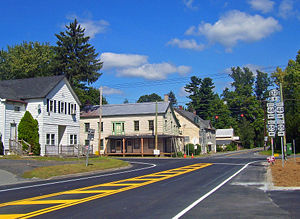
- ModenaModena, New YorkModena is an unincorporated hamlet in Ulster County, New York, United States. It is located in the northwestern corner of the town of Plattekill, centered at the junction of the US 44/NY 55 concurrency and NY 32. It has the ZIP Code 12548....
– A hamlet at the junction of Routes 44/55 and 32. - Modena Gardens – A hamlet northeast of New Hurley.
- PlattekillPlattekill (CDP), New YorkPlattekill is a hamlet in Ulster County, New York, USA. The population was 1,050 at the 2000 census. The community like its town is named after a local stream, the Platte Kill....
– The hamlet of Plattekill is in the southeast part of the town, west of the Thruway on Route 32. - Sylva – A hamlet west of Plattekill on Route 32.
- Tuckers Corners – A location near the east town line.