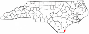
Pleasure Island (North Carolina)
Encyclopedia

Wilmington, North Carolina
Wilmington is a port city in and is the county seat of New Hanover County, North Carolina, United States. The population is 106,476 according to the 2010 Census, making it the eighth most populous city in the state of North Carolina...
. The coastal towns of Carolina Beach
Carolina Beach, North Carolina
Carolina Beach is a town in New Hanover County, North Carolina, United States. The population was 4,701 at the 2000 census. It is located on part of the Wilmington metropolitan area...
and Kure Beach
Kure Beach, North Carolina
Kure Beach (ˈkjʊərɪ KYUR-ee) is a town in New Hanover County, North Carolina about 15 miles south of Wilmington. It is part of the Wilmington Metropolitan Statistical Area. The population was 1,507 at the 2000 census...
, as well as the annexed community of Wilmington Beach
Wilmington Beach, North Carolina
Wilmington Beach was a coastal unincorporated community on Pleasure Island in North Carolina, U.S. that was annexed by the town of Carolina Beach in 2000. Prior to the annexation, the small community was a buffer between Carolina Beach and Kure Beach. U.S. Highway 421 and Ocean Boulevard are the...
, are located on the island. The Atlantic Ocean lies on the island's east side, the Cape Fear River
Cape Fear River
The Cape Fear River is a long blackwater river in east central North Carolina in the United States. It flows into the Atlantic Ocean near Cape Fear, from which it takes its name. The overall water quality of the river is continuously measured and monitored by and conducted by the , , and the...
lies on the west, the north side is bordered by Snows Cut (part of the Atlantic Intracoastal Waterway) and Carolina Beach Inlet. The southern end of the island was separated from Bald Head Island by Corncake Inlet until the inlet was shoaled and closed in 1999 by Hurricane Floyd
Hurricane Floyd
Hurricane Floyd was the sixth named storm, fourth hurricane, and third major hurricane in the 1999 Atlantic hurricane season. Floyd triggered the third largest evacuation in US history when 2.6 million coastal residents of five states were ordered from their homes as it approached...
; thus, technically Pleasure Island and Bald Head Island are not separate islands. Prior to the 1930 completion of Snow's Cut, the land that now forms Pleasure Island was in fact a peninsula known as Federal Point.
Found on the island is the eastern side of the Sunny Point Army Terminal, Carolina Beach State Park
Carolina Beach State Park
Carolina Beach State Park is a North Carolina state park in New Hanover County, North Carolina in the United States. It is near Carolina Beach, North Carolina and covers 761 acres on Pleasure Island at the mouth of the Cape Fear River.-Information:...
, and Fort Fisher
Fort Fisher
Fort Fisher was a Confederate fort during the American Civil War. It protected the vital trading routes of the port at Wilmington, North Carolina, from 1861 until its capture by the Union in 1865....
. U.S. Highway 421
U.S. Route 421 in North Carolina
U.S. Route 421 traverses approximately across North Carolina; from Fort Fisher, on a peninsula between the Atlantic and Cape Fear River, to the Tennessee state line near the community of Zionville....
is the only route on the island, and provides the only bridge access. A ferry at US 421
U.S. Route 421 in North Carolina
U.S. Route 421 traverses approximately across North Carolina; from Fort Fisher, on a peninsula between the Atlantic and Cape Fear River, to the Tennessee state line near the community of Zionville....
's southern terminus connects Pleasure Island to Southport
Southport, North Carolina
Southport is a city in Brunswick County, North Carolina, near the mouth of the Cape Fear River. It is part of the Wilmington Metropolitan Statistical Area...
at North Carolina Highway 211.
The Island Gazette is a local newspaper that serves the island communities.
Points of Interest
- Fort Fisher State Recreation AreaFort Fisher State Recreation AreaFort Fisher State Recreation Area is a North Carolina state park in New Hanover County, North Carolina in the United States. Located near Kure Beach, North Carolina, it includes Fort Fisher, site of a major naval engagement during the American Civil War. The recreation area also served as a home...
- North Carolina Aquarium at Fort FisherNorth Carolina AquariumsNorth Carolina Aquariums is a system of 3 public aquariums located in Kure Beach, Roanoke Island and Pine Knoll Shores. All are operated by the Aquariums Division of the North Carolina Department of Environment and Natural Resources since 1976 and are accredited by the Association of Zoos and...
- Carolina Beach State ParkCarolina Beach State ParkCarolina Beach State Park is a North Carolina state park in New Hanover County, North Carolina in the United States. It is near Carolina Beach, North Carolina and covers 761 acres on Pleasure Island at the mouth of the Cape Fear River.-Information:...

