
Plumstead, Norfolk
Encyclopedia
Plumstead is a village and a civil parish in the English
county of Norfolk
. The village is 19.7 miles (31.7 km) north north west of Norwich
, 9.5 miles (15.3 km) south-west of Cromer
and 134 miles (215.7 km) north-east of London
. The nearest town is Holt
which is 4.8 miles (7.7 km) to the north west of the village. The nearest railway station is in the town of Sheringham
where access to the national rail network can be made via the Bittern Line
to Norwich. The nearest airport is Norwich International Airport
. Plumstead falls within the area covered by North Norfolk District Council.
of 1085. In the great book Plumstead is recorded by the names Plumestead. The main landholder was William de Warenne
.
collection of medieval and continental glass brought here from Catton Hall, near Norwich, in the 1950s.
England
England is a country that is part of the United Kingdom. It shares land borders with Scotland to the north and Wales to the west; the Irish Sea is to the north west, the Celtic Sea to the south west, with the North Sea to the east and the English Channel to the south separating it from continental...
county of Norfolk
Norfolk
Norfolk is a low-lying county in the East of England. It has borders with Lincolnshire to the west, Cambridgeshire to the west and southwest and Suffolk to the south. Its northern and eastern boundaries are the North Sea coast and to the north-west the county is bordered by The Wash. The county...
. The village is 19.7 miles (31.7 km) north north west of Norwich
Norwich
Norwich is a city in England. It is the regional administrative centre and county town of Norfolk. During the 11th century, Norwich was the largest city in England after London, and one of the most important places in the kingdom...
, 9.5 miles (15.3 km) south-west of Cromer
Cromer
Cromer is a coastal town and civil parish in north Norfolk, England. The local government authority is North Norfolk District Council, whose headquarters is in Holt Road in the town. The town is situated 23 miles north of the county town, Norwich, and is 4 miles east of Sheringham...
and 134 miles (215.7 km) north-east of London
London
London is the capital city of :England and the :United Kingdom, the largest metropolitan area in the United Kingdom, and the largest urban zone in the European Union by most measures. Located on the River Thames, London has been a major settlement for two millennia, its history going back to its...
. The nearest town is Holt
Holt, Norfolk
Holt is a market town and civil parish in the English county of Norfolk. The town is north of the city of Norwich, west of Cromer and east of King's Lynn. The town is on the route of the A148 King's Lynn to Cromer road. The nearest railway station is in the town of Sheringham where access to the...
which is 4.8 miles (7.7 km) to the north west of the village. The nearest railway station is in the town of Sheringham
Sheringham railway station
Sheringham railway station is a timber halt in the town of Sheringham in the English county of Norfolk. The station is the terminus of the Bittern Line, operated by National Express East Anglia, and is 49 km north of...
where access to the national rail network can be made via the Bittern Line
Bittern Line
The Bittern Line is a railway line from Norwich to Cromer then Sheringham in Norfolk, England. It is one of the most scenic in the East of England traversing the Norfolk Broads on its route to the Area of Outstanding Natural Beauty on the North Norfolk Coast. The line is part of the Network Rail...
to Norwich. The nearest airport is Norwich International Airport
Norwich International Airport
Norwich International Airport , also known as Norwich Airport, is an airport in the City of Norwich within Norfolk, England north of the city centre and on the edge of the city's suburbs....
. Plumstead falls within the area covered by North Norfolk District Council.
History
Plumstead has an entry in the Domesday BookDomesday Book
Domesday Book , now held at The National Archives, Kew, Richmond upon Thames in South West London, is the record of the great survey of much of England and parts of Wales completed in 1086...
of 1085. In the great book Plumstead is recorded by the names Plumestead. The main landholder was William de Warenne
William de Warenne
William de Warenne may refer to:*William de Warenne, 1st Earl of Surrey *William de Warenne, 2nd Earl of Surrey *William de Warenne, 3rd Earl of Surrey *William de Warenne, 5th Earl of Surrey...
.
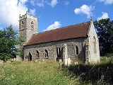
Saint Michael parish church
The parish church of Saint Michael was once much larger than it is today. On the south side of the building the low aisle has been demolished, and the clerestory filled in. The church's most notable feature is itscollection of medieval and continental glass brought here from Catton Hall, near Norwich, in the 1950s.