
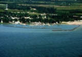
Port Sanilac, Michigan
Encyclopedia

Sanilac Township, Michigan
Sanilac Township is a civil township of Sanilac County in the U.S. state of Michigan. The population was 2,609 at the 2000 census. The village of Port Sanilac is within the township.-Geography:...
, Sanilac County
Sanilac County, Michigan
-Highways:* M-19* M-25* M-46* M-53* M-81* M-90-History:Sanilac County was probably named for a Wyandot chief named Sanilac. See List of Michigan county name etymologies....
in the U.S. state
U.S. state
A U.S. state is any one of the 50 federated states of the United States of America that share sovereignty with the federal government. Because of this shared sovereignty, an American is a citizen both of the federal entity and of his or her state of domicile. Four states use the official title of...
of Michigan
Michigan
Michigan is a U.S. state located in the Great Lakes Region of the United States of America. The name Michigan is the French form of the Ojibwa word mishigamaa, meaning "large water" or "large lake"....
. The population was 658 at the 2000 census
United States Census, 2000
The Twenty-second United States Census, known as Census 2000 and conducted by the Census Bureau, determined the resident population of the United States on April 1, 2000, to be 281,421,906, an increase of 13.2% over the 248,709,873 persons enumerated during the 1990 Census...
.
History
This village was originally a lumberjackLumberjack
A lumberjack is a worker in the logging industry who performs the initial harvesting and transport of trees for ultimate processing into forest products. The term usually refers to a bygone era when hand tools were used in harvesting trees principally from virgin forest...
settlement on the shore of Lake Huron
Lake Huron
Lake Huron is one of the five Great Lakes of North America. Hydrologically, it comprises the larger portion of Lake Michigan-Huron. It is bounded on the east by the Canadian province of Ontario and on the west by the state of Michigan in the United States...
named "Bark Shanty." In the late 1840s and 1850s, the settlement gained its first sawmill
Sawmill
A sawmill is a facility where logs are cut into boards.-Sawmill process:A sawmill's basic operation is much like those of hundreds of years ago; a log enters on one end and dimensional lumber exits on the other end....
, schoolhouse, and general store. In 1854, Bark Shanty's first post office opened. In 1857 the village was renamed to Port Sanilac, as it is in Sanilac Township in Sanilac County. Local legend attributes the name to a Wyandotte Indian Chief named Sanilac. See List of Michigan county name etymologies.
Local landmarks include the Port Sanilac lighthouse (burning kerosene
Kerosene
Kerosene, sometimes spelled kerosine in scientific and industrial usage, also known as paraffin or paraffin oil in the United Kingdom, Hong Kong, Ireland and South Africa, is a combustible hydrocarbon liquid. The name is derived from Greek keros...
from its opening in 1886 until its electrification in 1924) and a twenty-room Victorian mansion (now a museum) built in 1872 by a horse-and-buggy doctor, Dr. Joseph Loop.
The Sanilac Shores Underwater Preserve
Sanilac Shores Underwater Preserve
The Sanilac Shores Underwater Preserve was established to promote conservation of the submerged historical resources in Lake Huron near Port Sanilac, Michigan. The Sanilac Shores Underwater Preserve spans a total of of Lake Huron...
is a designated ship wreck preserve that is very popular with scuba divers.
Geography
According to the United States Census BureauUnited States Census Bureau
The United States Census Bureau is the government agency that is responsible for the United States Census. It also gathers other national demographic and economic data...
, the village has a total area of 0.7 square miles (1.8 km²), all land. It is located at 43°25′56"N 82°32′33"W. It is considered to be part of the Thumb
The Thumb
The Thumb is a region and a peninsula of Michigan, so named because the Lower Peninsula is shaped like a mitten; thus the Thumb is the area that looks like the thumb of the mitten. The Thumb is generally considered to be in the Mid-Michigan area of the state, located east of Flint/Tri-Cities...
of Michigan
Michigan
Michigan is a U.S. state located in the Great Lakes Region of the United States of America. The name Michigan is the French form of the Ojibwa word mishigamaa, meaning "large water" or "large lake"....
, which in turn is a subregion of the Flint/Tri-Cities
Flint/Tri-Cities
The Flint/Tri-Cities Region or Saginaw Valley is a region in the Lower Peninsula of the U.S. state of Michigan. The region is composed of the area surrounding Flint, Michigan, the Tri Cities, the Saginaw Bay and Saginaw River . Flint's population is 102,434; it is the seventh largest city in Michigan...
.
Demographics
As of the censusCensus
A census is the procedure of systematically acquiring and recording information about the members of a given population. It is a regularly occurring and official count of a particular population. The term is used mostly in connection with national population and housing censuses; other common...
of 2000, there were 658 people, 319 households, and 176 families residing in the village. The population density
Population density
Population density is a measurement of population per unit area or unit volume. It is frequently applied to living organisms, and particularly to humans...
was 908.8 per square mile (352.9/km2). There were 437 housing units at an average density of 603.6 per square mile (234.3/km2). The racial makeup of the village was 96.66% White, 0.76% Native American, 0.15% Asian, 0.61% from other races
Race (United States Census)
Race and ethnicity in the United States Census, as defined by the Federal Office of Management and Budget and the United States Census Bureau, are self-identification data items in which residents choose the race or races with which they most closely identify, and indicate whether or not they are...
, and 1.82% from two or more races. Hispanic or Latino of any race were 2.13% of the population.
There were 319 households out of which 20.7% had children under the age of 18 living with them, 44.5% were married couples
Marriage
Marriage is a social union or legal contract between people that creates kinship. It is an institution in which interpersonal relationships, usually intimate and sexual, are acknowledged in a variety of ways, depending on the culture or subculture in which it is found...
living together, 9.1% had a female householder with no husband present, and 44.8% were non-families. 42.0% of all households were made up of individuals and 26.6% had someone living alone who was 65 years of age or older. The average household size was 2.03 and the average family size was 2.77.
In the village the population was spread out with 19.9% under the age of 18, 8.8% from 18 to 24, 20.1% from 25 to 44, 22.3% from 45 to 64, and 28.9% who were 65 years of age or older. The median age was 46 years. For every 100 females there were 77.8 males. For every 100 females age 18 and over, there were 72.2 males.
The median income for a household in the village was $28,409, and the median income for a family was $38,250. Males had a median income of $30,795 versus $21,875 for females. The per capita income
Per capita income
Per capita income or income per person is a measure of mean income within an economic aggregate, such as a country or city. It is calculated by taking a measure of all sources of income in the aggregate and dividing it by the total population...
for the village was $18,153. About 4.8% of families and 7.8% of the population were below the poverty line, including 15.3% of those under age 18 and 7.1% of those age 65 or over.
Education
Carsonville-Port Sanilac Schools has a combined high school and middle school off M-46M-46 (Michigan highway)
M-46 is an east–west state trunkline highway in the US state of Michigan between Muskegon and Port Sanilac, terminating near Lake Michigan and Lake Huron on each end. Except for the north–south segment that corresponds with the US Highway 131 freeway between Cedar Springs and Howard City, M-46 is...
between Port Sanilac and Carsonville
Carsonville, Michigan
Carsonville is a village in Sanilac County of the U.S. state of Michigan. As of the 2000 census, the village population was 502. The village is situated at on the boundary between Bridgehampton Township and Washington Township, with about half the village in each.The village began with a store...
, Michigan
Michigan
Michigan is a U.S. state located in the Great Lakes Region of the United States of America. The name Michigan is the French form of the Ojibwa word mishigamaa, meaning "large water" or "large lake"....
. Port Sanilac's last elementary school closed in the early 1980s and the building is now used as the Bark Shanty Community Center. Elementary students are bused to nearby Carsonville
Carsonville, Michigan
Carsonville is a village in Sanilac County of the U.S. state of Michigan. As of the 2000 census, the village population was 502. The village is situated at on the boundary between Bridgehampton Township and Washington Township, with about half the village in each.The village began with a store...
, Michigan
Michigan
Michigan is a U.S. state located in the Great Lakes Region of the United States of America. The name Michigan is the French form of the Ojibwa word mishigamaa, meaning "large water" or "large lake"....
for schooling.
Further reading
- Clarke Historical Library, Central Michigan University, Bibliography on Sanilac County
- Raymond, Oliver. Shingle Shavers and Berry Pickers. (Port Sanilac, MI: Raymond), 1976.