Port of Eden
Encyclopedia
The Port of Eden is a small seaport in Twofold Bay
adjacent to the town of Eden
on the south coast of New South Wales
, Australia
.
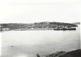
ateden1903.jpg) The bay was first charted by explorer George Bass
The bay was first charted by explorer George Bass
in 1797 and has been used for commercial whaling
and fishing since the 1840's.
From the 1850s to 1950s the port was serviced by steamship companies, including the Illawarra Steam Navigation Company
.
 The port is a principal export point for timber products, with a trade throughput of more than one million tonnes a year. Each year approximately 800,000 tonnes of woodchips are exported to south-east Asia via the port, as well as 60,000 mass tonnes of softwood timber to Japan
and Korea
. Woodchip storage and packaging facilities were constructed by Harris Daishowa in 1971.
, Bombala
and Cooma
, and as a stopover for national and international cruise ships. In 1960 Mobil
constructed a dedicated wharf, tanks and plant for small-scale petroleum imports and distribution to southern New South Wales.
An average of 70 commercial vessels visit the Port of Eden each year. Civilian shipping movements in the port are regulated by a harbour master appointed by NSW Maritime
.
The port is also shared with the Department of Defence
and services approximately 40 Naval
ships a year. The Navy facility consists of a wharf, an access jetty and road, and a land-based munitions store 15 kilometres from the bay and surrounded by a 100 hectare exclusion zone.

 The port consists of two commercial shipping wharves, the Mobil petroleum wharf, a cargo storage area and ancillary facilities.
The Breakwater Wharf caters for the timber industry, the fishing fleet and cruise shipping. Wharf length is 105 metres with depths ranging from three metres to the landward end and 8.8 metres seaward, with a tidal variation of two metres. The wharf itself is concrete with rubber fending.
In 2003 a multi-purpose wharf and munitions facility was constructed to expand naval repair and refit operations and increase the port's timber export capacity by 150,000 tonnes. Wharf length is 200 metres, accessed via a 560 metre timber jetty. Berthing depth is 12 metres but maximum vessel raft is restricted by a low-water fairway depth of 11 metres.
The common-user cargo storage area covers 10 hectares with a gravel surface and sealed internal roads. Storage capacity is estimated to reach 500,000 tonnes in 2010/11.
Twofold Bay
Twofold Bay is a bay on the south coast of New South Wales, Australia, close to the border with Victoria. The bay has an area of about 30 square kilometres. Close to North Head is a conspicuous islet, Mewstone Rock. About five km south of the islet is Red Point which forms the southern headland of...
adjacent to the town of Eden
Eden, New South Wales
Eden is a coastal town in the South Coast region of New South Wales, Australia. The town, south of the state capital Sydney near the border with Victoria, is located between Nullica Bay to the south and Calle Calle Bay, the northern reach of Twofold Bay, and built on undulating land adjacent to a...
on the south coast of New South Wales
New South Wales
New South Wales is a state of :Australia, located in the east of the country. It is bordered by Queensland, Victoria and South Australia to the north, south and west respectively. To the east, the state is bordered by the Tasman Sea, which forms part of the Pacific Ocean. New South Wales...
, Australia
Australia
Australia , officially the Commonwealth of Australia, is a country in the Southern Hemisphere comprising the mainland of the Australian continent, the island of Tasmania, and numerous smaller islands in the Indian and Pacific Oceans. It is the world's sixth-largest country by total area...
.
ateden1903.jpg)
George Bass
George Bass was a British naval surgeon and explorer of Australia.-Early years:He was born on 30 January 1771 at Aswarby, a hamlet near Sleaford, Lincolnshire, the son of a tenant farmer, George Bass, and a local beauty named Sarah Nee Newman. His father died in 1777 when Bass was 6...
in 1797 and has been used for commercial whaling
Whaling
Whaling is the hunting of whales mainly for meat and oil. Its earliest forms date to at least 3000 BC. Various coastal communities have long histories of sustenance whaling and harvesting beached whales...
and fishing since the 1840's.
From the 1850s to 1950s the port was serviced by steamship companies, including the Illawarra Steam Navigation Company
Illawarra Steam Navigation Company
The Illawarra Steam Navigation Company was a shipping company that serviced the south coast of New South Wales, Australia from 1858 to the early 1950s...
.
Industries

Japan
Japan is an island nation in East Asia. Located in the Pacific Ocean, it lies to the east of the Sea of Japan, China, North Korea, South Korea and Russia, stretching from the Sea of Okhotsk in the north to the East China Sea and Taiwan in the south...
and Korea
Korea
Korea ) is an East Asian geographic region that is currently divided into two separate sovereign states — North Korea and South Korea. Located on the Korean Peninsula, Korea is bordered by the People's Republic of China to the northwest, Russia to the northeast, and is separated from Japan to the...
. Woodchip storage and packaging facilities were constructed by Harris Daishowa in 1971.
Fishing
A substantial fishing fleet also operates from the port and from Snug Cove. Minor port uses include import and export services for the towns of Eden BegaBega, New South Wales
Bega is a town in the south-east of New South Wales, Australia in the Bega Valley Shire. It is the economic centre for the Bega Valley.-Place name:One claim is that place name Bega is derived from the local Aboriginal word meaning "big camping ground"....
, Bombala
Bombala, New South Wales
Bombala is a town in the Monaro region of south-eastern New South Wales, Australia, in Bombala Council. It is located approximately south of the state capital, Sydney, and south of the town of Cooma. The name derives from an Aboriginal word meaning "Meeting of the waters". The town lies on the...
and Cooma
Cooma, New South Wales
-Education: is Cooma's only public high school, it serves the town and seven of the neighbouring rural towns and villages such as Berridale, Jindabyne, Nimmitabel, Bredbo and Dalgety....
, and as a stopover for national and international cruise ships. In 1960 Mobil
Mobil
Mobil, previously known as the Socony-Vacuum Oil Company, was a major American oil company which merged with Exxon in 1999 to form ExxonMobil. Today Mobil continues as a major brand name within the combined company, as well as still being a gas station sometimes paired with their own store or On...
constructed a dedicated wharf, tanks and plant for small-scale petroleum imports and distribution to southern New South Wales.
An average of 70 commercial vessels visit the Port of Eden each year. Civilian shipping movements in the port are regulated by a harbour master appointed by NSW Maritime
NSW Maritime
NSW Maritime was an agency in the Government of New South Wales, Australia. NSW Maritime was the State Government Authority responsible for marine safety, regulation of commercial and recreational boating and oversight of port operations...
.
The port is also shared with the Department of Defence
Department of Defence (Australia)
The Australian Department of Defence is a Federal Government Department. It forms part of the Australian Defence Organisation along with the Australian Defence Force . The Defence mission is to defend Australia and its national interests...
and services approximately 40 Naval
Royal Australian Navy
The Royal Australian Navy is the naval branch of the Australian Defence Force. Following the Federation of Australia in 1901, the ships and resources of the separate colonial navies were integrated into a national force: the Commonwealth Naval Forces...
ships a year. The Navy facility consists of a wharf, an access jetty and road, and a land-based munitions store 15 kilometres from the bay and surrounded by a 100 hectare exclusion zone.
Facilities


The Breakwater Wharf caters for the timber industry, the fishing fleet and cruise shipping. Wharf length is 105 metres with depths ranging from three metres to the landward end and 8.8 metres seaward, with a tidal variation of two metres. The wharf itself is concrete with rubber fending.
In 2003 a multi-purpose wharf and munitions facility was constructed to expand naval repair and refit operations and increase the port's timber export capacity by 150,000 tonnes. Wharf length is 200 metres, accessed via a 560 metre timber jetty. Berthing depth is 12 metres but maximum vessel raft is restricted by a low-water fairway depth of 11 metres.
The common-user cargo storage area covers 10 hectares with a gravel surface and sealed internal roads. Storage capacity is estimated to reach 500,000 tonnes in 2010/11.

