.gif)
Pra River (Ghana)
Encyclopedia

Ghana
Ghana , officially the Republic of Ghana, is a country located in West Africa. It is bordered by Côte d'Ivoire to the west, Burkina Faso to the north, Togo to the east, and the Gulf of Guinea to the south...
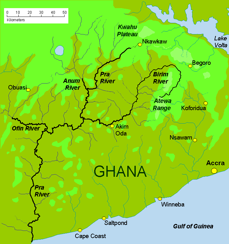
, the easternmost and the largest of the three principal rivers that drain the area south of the Volta
Lake Volta
Lake Volta is the largest reservoir by surface area in the world, and the fourth largest one by water volume. It is located completely within the country of Ghana, and it has a surface area of about 8,502 km² . Lake Volta lies along the Greenwich Meridian, and just six degrees of latitude...
divide. Rising in the Kwahu Plateau
Kwahu Plateau
The Kwahu Plateau is a long plateau in Ghana. It forms the country's watershed, separating the two main river networks in the country....
near Mpraeso
Mpraeso
Mpraeso is the capital of the Kwahu South District in Ghana, located at an altitude of 367 m on the Kwahu Plateau, which forms the south-west boundary of Lake Volta. Mpraeso is about three hours' drive north-west from Accra...
and flowing southward for 240 km through rich cocoa and farming areas and valuable forests in the Akan lowlands, the Pra enters the Gulf of Guinea
Gulf of Guinea
The Gulf of Guinea is the northeasternmost part of the tropical Atlantic Ocean between Cape Lopez in Gabon, north and west to Cape Palmas in Liberia. The intersection of the Equator and Prime Meridian is in the gulf....
east of Takoradi. In the 19th century, the Pra served as the border between the Ashanti Confederacy and the Gold Coast
Gold Coast (British colony)
The Gold Coast was a British colony on the Gulf of Guinea in west Africa that became the independent nation of Ghana in 1957.-Overview:The first Europeans to arrive at the coast were the Portuguese in 1471. They encountered a variety of African kingdoms, some of which controlled substantial...
.
The Pra has many cataracts, notably the Bosomasi Rapids at Anyinabrim, and for most of its length is not navigable even by canoe. However, in the early part of the twentieth century the Pra was used extensively to float timber to the coast for export. This trade is now carried by road and rail transportation. The main tributaries are the Ofin, Anum and Birim
Birim River
The Birim River is one of the main tributaries of the Pra River in Ghana and the country's most important diamond-producing area, flowing through most of the width of the Eastern region. The river rises in the east of the Atewa Range, flows north through the gap between this range and the Kwahu...
rivers. The northern part of the Pra is still worked for artisan gold with metallic mercury, which has caused some contamination. The Birim river valley is a major source of diamonds.
Oda
ODA
*ODA or Oda may refer to:*Oda , a typical Albanian room*Oda , is a room within harem especially in the Ottoman Empire- Computing :* Open Data Center Alliance - Data Center and Cloud Infrastructure Standards...
is the commercial centre of the northern Pra basin.

