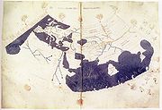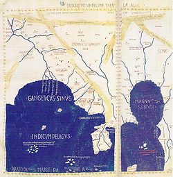
Ptolemy's world map
Encyclopedia


Ptolemy
Claudius Ptolemy , was a Roman citizen of Egypt who wrote in Greek. He was a mathematician, astronomer, geographer, astrologer, and poet of a single epigram in the Greek Anthology. He lived in Egypt under Roman rule, and is believed to have been born in the town of Ptolemais Hermiou in the...
's book Geographia
Geographia (Ptolemy)
The Geography is Ptolemy's main work besides the Almagest...
, written c. 150. Although authentic maps have never been found, the Geographia contains thousands of references to various parts of the old world, with coordinates for most, which allowed cartographers to reconstruct Ptolemy's world view when the manuscript was re-discovered around 1300 AD.
Perhaps the most significant contribution of Ptolemy and his maps is the first uses of longitudinal and latitudinal lines and the specifying of terrestrial locations by celestial observations. When his Geographia was translated from Greek
Greek language
Greek is an independent branch of the Indo-European family of languages. Native to the southern Balkans, it has the longest documented history of any Indo-European language, spanning 34 centuries of written records. Its writing system has been the Greek alphabet for the majority of its history;...
into Arabic
Arabic language
Arabic is a name applied to the descendants of the Classical Arabic language of the 6th century AD, used most prominently in the Quran, the Islamic Holy Book...
in the 9th century and subsequently into Latin in Western Europe at the beginning of the 15th century, the idea of a global coordinate system revolutionized medieval Islamic and European geographical thinking and put it upon a scientific and numerical basis.
Contents
The map distinguishes two large enclosed seas, the first one being the Mediterranean, the second one being the Indian OceanIndian Ocean
The Indian Ocean is the third largest of the world's oceanic divisions, covering approximately 20% of the water on the Earth's surface. It is bounded on the north by the Indian Subcontinent and Arabian Peninsula ; on the west by eastern Africa; on the east by Indochina, the Sunda Islands, and...
(Indicum Pelagus), which extends into the South China Sea
South China Sea
The South China Sea is a marginal sea that is part of the Pacific Ocean, encompassing an area from the Singapore and Malacca Straits to the Strait of Taiwan of around...
(Magnus Sinus) in the East. The major geographical locations are Europe
Europe
Europe is, by convention, one of the world's seven continents. Comprising the westernmost peninsula of Eurasia, Europe is generally 'divided' from Asia to its east by the watershed divides of the Ural and Caucasus Mountains, the Ural River, the Caspian and Black Seas, and the waterways connecting...
, the Middle-East, India
India
India , officially the Republic of India , is a country in South Asia. It is the seventh-largest country by geographical area, the second-most populous country with over 1.2 billion people, and the most populous democracy in the world...
, Sri Lanka
Sri Lanka
Sri Lanka, officially the Democratic Socialist Republic of Sri Lanka is a country off the southern coast of the Indian subcontinent. Known until 1972 as Ceylon , Sri Lanka is an island surrounded by the Indian Ocean, the Gulf of Mannar and the Palk Strait, and lies in the vicinity of India and the...
(Taprobane), the Malay Peninsula
Malay Peninsula
The Malay Peninsula or Thai-Malay Peninsula is a peninsula in Southeast Asia. The land mass runs approximately north-south and, at its terminus, is the southern-most point of the Asian mainland...
(Aurea Chersonesus or "Golden Peninsula
Peninsula
A peninsula is a piece of land that is bordered by water on three sides but connected to mainland. In many Germanic and Celtic languages and also in Baltic, Slavic and Hungarian, peninsulas are called "half-islands"....
") and beyond it China
China
Chinese civilization may refer to:* China for more general discussion of the country.* Chinese culture* Greater China, the transnational community of ethnic Chinese.* History of China* Sinosphere, the area historically affected by Chinese culture...
(Sinae).
The Geographia and the maps derived from it probably played an important role in the expansion of the Roman Empire
Roman Empire
The Roman Empire was the post-Republican period of the ancient Roman civilization, characterised by an autocratic form of government and large territorial holdings in Europe and around the Mediterranean....
to the East. Trade throughout the Indian Ocean
Indian Ocean
The Indian Ocean is the third largest of the world's oceanic divisions, covering approximately 20% of the water on the Earth's surface. It is bounded on the north by the Indian Subcontinent and Arabian Peninsula ; on the west by eastern Africa; on the east by Indochina, the Sunda Islands, and...
was extensive from the 2nd century, and many Roman trading ports have been identified in India
India
India , officially the Republic of India , is a country in South Asia. It is the seventh-largest country by geographical area, the second-most populous country with over 1.2 billion people, and the most populous democracy in the world...
. From these ports, Roman embassies to China are recorded in Chinese historical sources from around 166.
The Danish historian Gudmund Schütte
Gudmund Schütte
Gudmund Schütte was aDanish philologist and historian specialized inthe Danish prehistory.-Bibliography :...
attempted to reconstruct the Danish part of Ptolemy's world map. This derivative includes several place- and tribe
Tribe
A tribe, viewed historically or developmentally, consists of a social group existing before the development of, or outside of, states.Many anthropologists use the term tribal society to refer to societies organized largely on the basis of kinship, especially corporate descent groups .Some theorists...
-names, some of which can be interpreted to their
contemporary equivalent. The most prominent feature of the map is the peninsula
Peninsula
A peninsula is a piece of land that is bordered by water on three sides but connected to mainland. In many Germanic and Celtic languages and also in Baltic, Slavic and Hungarian, peninsulas are called "half-islands"....
Jutland
Jutland
Jutland , historically also called Cimbria, is the name of the peninsula that juts out in Northern Europe toward the rest of Scandinavia, forming the mainland part of Denmark. It has the North Sea to its west, Kattegat and Skagerrak to its north, the Baltic Sea to its east, and the Danish–German...
placed north of the river Albis
Elbe
The Elbe is one of the major rivers of Central Europe. It rises in the Krkonoše Mountains of the northwestern Czech Republic before traversing much of Bohemia , then Germany and flowing into the North Sea at Cuxhaven, 110 km northwest of Hamburg...
Trêva, west of the Saxonôn Nesôi
Nesoi
In Greek mythology, the Nesoi were the goddesses of islands. Each island was said to have its own personification. They were classified as one of the ancient elemental gods called Protogenoi....
(archipelago
Archipelago
An archipelago , sometimes called an island group, is a chain or cluster of islands. The word archipelago is derived from the Greek ἄρχι- – arkhi- and πέλαγος – pélagos through the Italian arcipelago...
), east of the Skandiai Nêsoi
Nesoi
In Greek mythology, the Nesoi were the goddesses of islands. Each island was said to have its own personification. They were classified as one of the ancient elemental gods called Protogenoi....
, which itself lies west of a larger island Skandia. Skandia is home to the Goutai
Goths
The Goths were an East Germanic tribe of Scandinavian origin whose two branches, the Visigoths and the Ostrogoths, played an important role in the fall of the Roman Empire and the emergence of Medieval Europe....
in the center, and the Phiraisoi
Firaesi
The Firaesi or Phiraisoi are a people listed in Ptolemy’s Geography .Ptolemy’s view of the region is not very precise, but he places them on the east side of what he believed to be an island, Scandia...
in the east.
North of Jutland lies a third archipelago Alokiai Nêsoi
Nesoi
In Greek mythology, the Nesoi were the goddesses of islands. Each island was said to have its own personification. They were classified as one of the ancient elemental gods called Protogenoi....
. South of the Albis lives the Lakkobardoi
Lombards
The Lombards , also referred to as Longobards, were a Germanic tribe of Scandinavian origin, who from 568 to 774 ruled a Kingdom in Italy...
and to its north
the Saxones
Saxons
The Saxons were a confederation of Germanic tribes originating on the North German plain. The Saxons earliest known area of settlement is Northern Albingia, an area approximately that of modern Holstein...
. The west coast of Jutland is home to the Sigulônes, the Sabaliggio, the Kobandoi, the Eundusioi and the northernmost Kimbroi (possibly Cimbri
Cimbri
The Cimbri were a tribe from Northern Europe, who, together with the Teutones and the Ambrones threatened the Roman Republic in the late 2nd century BC. The Cimbri were probably Germanic, though some believe them to be of Celtic origin...
). The center and east is home to the Kimbrikê (possibly Cimbri
Cimbri
The Cimbri were a tribe from Northern Europe, who, together with the Teutones and the Ambrones threatened the Roman Republic in the late 2nd century BC. The Cimbri were probably Germanic, though some believe them to be of Celtic origin...
), the Chersonêsos and the Charudes
Charudes
Charudes is the scholarly Latinization of an Germanic tribe known in Ptolemy as the Charoudes. They are stated to have lived on the east side of the Cimbric Chersonese, Ptolemy's term for Jutland...
.
External links
- Cosmographia by Claudius Ptolemaeus in The European Library 2nd image
- Ptolemy and other early maps http://www.mlahanas.de/Greeks/PtolemyMap.htm

