Raktamaritika
Encyclopedia

Raktamaritika is one of the lost kingdoms of Thai history. Raktamaritika is a Sanskrit
Sanskrit
Sanskrit , is a historical Indo-Aryan language and the primary liturgical language of Hinduism, Jainism and Buddhism.Buddhism: besides Pali, see Buddhist Hybrid Sanskrit Today, it is listed as one of the 22 scheduled languages of India and is an official language of the state of Uttarakhand...
name meaning red earth land, while in Chinese records it is named Chi-Tu-Guo (Chinese: 赤土国, pinyin: Chì-tǔ-guó, Chi – red, Tu – earth, Guo – country or state). The Sui Dynasty
Sui Dynasty
The Sui Dynasty was a powerful, but short-lived Imperial Chinese dynasty. Preceded by the Southern and Northern Dynasties, it ended nearly four centuries of division between rival regimes. It was followed by the Tang Dynasty....
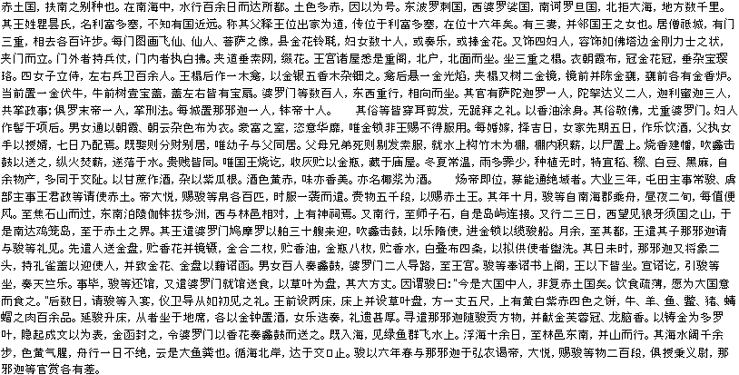
(581–618) chronicles records an advanced kingdom called Chitu in 607, when Chang Chun was sent as an ambassador there.
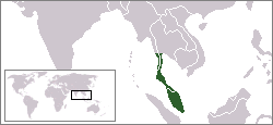
Location of Raktamaritika


Phatthalung Province
Phatthalung is one of the southern provinces of Thailand. Neighboring provinces are Nakhon Si Thammarat, Songkhla, Satun and Trang.-Geography:...
/ Songkhla
Songkhla Province
Songkhla is one of the southern provinces of Thailand. Neighboring provinces are Satun, Phatthalung, Nakhon Si Thammarat, Pattani and Yala. To the south it borders Kedah and Perlis of Malaysia....
area. The ruins around the Songkhla lake
Songkhla Lake
The Songkhla lake is the largest natural lake in Thailand, located on the Malay peninsula in the southern part of the country. Covering an area of 1,040 km² it borders the provinces of Songkhla and Phatthalung. Despite being called a lake, this water surface is actually a lagoon complex...
such as Bang Kaeo
Amphoe Bang Kaeo
Bang Kaeo is a district of Phatthalung Province, southern Thailand.-Geography:Neighboring districts are Pak Phayun, Pa Bon, Tamot, and Khao Chaisoni of Phatthalung Province, and Krasae Sin of Songkhla Province....
in Phatthalung or Sathing Phra
Amphoe Sathing Phra
Sathing Phra is a district in the northern part of Songkhla Province, southern Thailand.-Geography:Neighboring districts are Singhanakhon of Songkhla Province, Pak Phayun of Phatthalung Province, Krasae Sin and Ranot of Songkhla Province again...
in Songkhla then might be one of the cities of Raktamaritika.
Songkhla vicinity theory
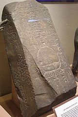
The inscription of the Buddhagupta Stone found in Kedah mentioned a Raktamaritika, the meaning is red earth land, to be the home town of a seafarer named Buddhagupta.The old name of Songkhla is Singgora (City of Lions), which coincides with the fact that according to the Chinese chronicles the capital of Chitu was Sing-Ha
Singh
Also see SinhaSingh is a common title, middle name, or surname in Northern India and South India used by sikhs warriors and kings. eg. Man Singh I, Maharana Pratap Singh. It is derived from the Sanskrit word Siṃha meaning "lion and used by Ahir kings of Nepal". It is also used in Sri Lanka by...
(means lion) and also the nearby Singhanakhon district.
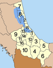
The location of Songkhla and its districts around the Songkhla lake :
| No. 1 | Mueang Songkhla Amphoe Mueang Songkhla Mueang Songkhla is the capital district of Songkhla Province, southern Thailand.-Geography:Neighboring districts are Chana, Na Mom, Hat Yai and Singhanakhon of Songkhla Province... |
| No. 2 | Sathing Phra Amphoe Sathing Phra Sathing Phra is a district in the northern part of Songkhla Province, southern Thailand.-Geography:Neighboring districts are Singhanakhon of Songkhla Province, Pak Phayun of Phatthalung Province, Krasae Sin and Ranot of Songkhla Province again... |
| No. 9 | Rattaphum Amphoe Rattaphum -Geography:Neighboring districts are Khuan Niang, Bang Klam and Hat Yai of Songkhla Province, Khuan Kalong of Satun Province and Pa Bon of Phatthalung Province.-Administration:... |
| No.15 | Singhanakhon Amphoe Singhanakhon Singhanakhon is a district in the northern part of Songkhla Province, southern Thailand.-Geography:Neighboring districts are Mueang Songkhla, Hat Yai, Khuan Niang of Songkhla Province, Pak Phayun of Phatthalung Province and Sathing Phra of Songkhla Province again... |
This name may also be related to Tambralinga
Tambralinga
Tambralinga was an ancient kingdom located on the Malay Peninsula that at one time came under the influence of Srivijaya. The name had been forgotten until scholars recognized Tambralinga as Nagara Sri Dharmaraja. Early records are scarce while estimations range from the seventh to fourteenth...
because there is "Tam" (means red) in this name as same as Raktamaritika and Tampapanni. And this state has appeared in 642, the same area of the central Malay peninsula after Chitu has already faded away from the history.
The best evidence supporting this theory is the mention that when the envoys left Chitu, the sailing took 10 days to reach Champa
Champa
The kingdom of Champa was an Indianized kingdom that controlled what is now southern and central Vietnam from approximately the 7th century through to 1832.The Cham people are remnants...
, which indicates the kingdom was located at the ‘red earth’ areas such as Rattaphum
Amphoe Rattaphum
-Geography:Neighboring districts are Khuan Niang, Bang Klam and Hat Yai of Songkhla Province, Khuan Kalong of Satun Province and Pa Bon of Phatthalung Province.-Administration:...
because Rattaphum means red earth as well.
Raktamaritika in Chinese chronicle

Gautama Buddha
Siddhārtha Gautama was a spiritual teacher from the Indian subcontinent, on whose teachings Buddhism was founded. In most Buddhist traditions, he is regarded as the Supreme Buddha Siddhārtha Gautama (Sanskrit: सिद्धार्थ गौतम; Pali: Siddhattha Gotama) was a spiritual teacher from the Indian...
) and the king is Li-Fu-Duo-Se. According to Chinese records, Chitu was built by peoples who sailed from the coast of Funan. Centuries later, the local inhabitants, replaced Funan peoples... ...Chitu is a derivation nation of Funan, located in within the southern sea, sailing hundred days to reach, the majority terrain was red, thus named Red Earth country. East bordering Po-Lo-La, West bordering Po-Lo-So, South bordering Ho-Lo-Tan, North reaching the sea, thousands of square miles in land area. The king has three wives and the kingdom embraced Buddhism. The city that he keep his court is Seng-Chi (Sing-ha). ...".

