Ranongga
Encyclopedia

New Georgia Islands
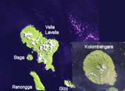
The New Georgia Islands are part of the Western Province of the Solomon Islands. They are located to the northwest of Guadalcanal. The larger islands are mountainous and covered in rain forest. The main islands are New Georgia, Vella Lavella, Kolombangara , Ghizo, Vangunu, Rendova and Tetepare...
group of Western Province
Western Province (Solomon Islands)
Western Province is the largest of the provinces of the Solomon Islands. The area is renowned for its beautiful tropical islands, excellent diving and snorkelling, coral reefs and WWII wrecks, ecotourism lodges, and head-hunting shrines...
, Solomon Islands
Solomon Islands
Solomon Islands is a sovereign state in Oceania, east of Papua New Guinea, consisting of nearly one thousand islands. It covers a land mass of . The capital, Honiara, is located on the island of Guadalcanal...
.
History
Ranongga was sighted in 1787 by sailors Read and Dale.On August 18, 1959, a seismic sea wave was generated off the west coast of Ranongga Island, at 08 hr 05 min. Soon after, large waves were observed soon in Vori, on the northern coast of the island. The sea receded by 15m and then returned to its original position.
Geography
Ranongga is a 28 km (17 mi) long, narrow island, located 8 km (5 mi) north-east of Simbo IslandSimbo
Simbo is an island in the Solomon Islands; it is located in the Western Province. It was known to early Europeans as Eddystone Island. Simbo is actually two main islands, one small island called Nusa Simbo separated by a saltwater lagoon from a larger one...
and south-west of Gizo
Gizo
Gizo is the capital of the Western Province in the Solomon Islands. With a population of 6,154 , it is the second largest town in the country. It is situated on Ghizo Island approximately 380 kilometers west-northwest of the capital, Honiara, and is just southwest of the larger island of Kolombangara...
, the capital of Western Province. The highest point is Mt. Kela (869m)
2007 earthquake
In April 2007, an earthquake rocked Ranongga Island, along with many parts of the Solomon IslandsSolomon Islands
Solomon Islands is a sovereign state in Oceania, east of Papua New Guinea, consisting of nearly one thousand islands. It covers a land mass of . The capital, Honiara, is located on the island of Guadalcanal...
. Land thrust from the quake extended out the shoreline of Ranongga Island by up to 70 meters (230 ft) according to local residents. This has left many once pristine coral reefs exposed on the newly formed beaches.
Demographics
Most of the villages are situated on the eastern side of the island. The Ghanongga languageGhanongga language
Ghanongga is an Oceanic language spoken by about 2,500 people on Ranongga Island, Solomon Islands....
is spoken by about 2500 people on the Ranongga Island.

