River Kent
Encyclopedia
The River Kent is a short river in the county of Cumbria
in England
. The river originates in hills surrounding Kentmere
, and flows for around 20 miles (32 km) into the north of Morecambe Bay. The Lake District National Park
includes the upper reaches of the river within its boundaries.
The river passes through Kentmere, Staveley
, Burneside
, Kendal
and Sedgwick
. Near Sedgwick, the river passes through a rock gorge which produces a number of low waterfalls. This section is popular with kayak
ers as it offers high quality whitewater
for several days after rain.
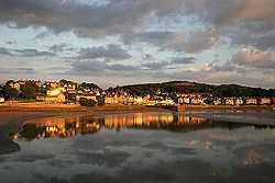
The village of Arnside
lies alongside the Kent estuary.
On high spring tides, a tidal bore
known as the Arnside Bore
forms in the estuary opposite Arnside. The wave is often about 0.5m high.
, Sprint
and Gowan
join the Kent to the north of Kendal, with the river also joined by the River Gilpin
and River Winster
as it nears its estuary.
Lingmell Gill (into Kentmere Reservoir)
Skeel Gill and Bryant's Gill
Ullstone Gill
Nunnery Beck
Kill Gill
Hall Gill
Park Beck
Hall Beck
River Gowan
River Sprint
River Mint
River Gilpin
River Bela
River Winster
, which was constructed in the mid-19th century to control the flow of the river for the benefit of water mills. The river was used to power numerous mills in the past , including two at Staveley, Kentmere water mill, and also the James Cropper paper factory at Burneside. One of the weir
s at Staveley produces electricity for Staveley Mill Yard
via a micro hydro
scheme. In 2010 planning permission was granted for a hydro-electric scheme at Kentmere.
, primarily as an important habitat for the endangered
White-clawed Crayfish (Austropotamobius pallipes
).
Fish species include salmon
and trout
. In the twentieth century fish ladders were constructed alongside the dams of mill-ponds to allow migratory fish to swim up to Kentmere.

Cumbria
Cumbria , is a non-metropolitan county in North West England. The county and Cumbria County Council, its local authority, came into existence in 1974 after the passage of the Local Government Act 1972. Cumbria's largest settlement and county town is Carlisle. It consists of six districts, and in...
in England
England
England is a country that is part of the United Kingdom. It shares land borders with Scotland to the north and Wales to the west; the Irish Sea is to the north west, the Celtic Sea to the south west, with the North Sea to the east and the English Channel to the south separating it from continental...
. The river originates in hills surrounding Kentmere
Kentmere
Kentmere is a valley, village and civil parish in the Lake District National Park, a few miles from Kendal in the South Lakeland district of Cumbria, England. It is historically part of Westmorland...
, and flows for around 20 miles (32 km) into the north of Morecambe Bay. The Lake District National Park
Lake District National Park
The Lake District National Park is located in the north-west of England and is the largest of the English National Parks and the second largest in the United Kingdom. It is in the central and most-visited part of the Lake District....
includes the upper reaches of the river within its boundaries.
The river passes through Kentmere, Staveley
Staveley, Cumbria
Staveley is a village in the District of South Lakeland in Cumbria, England. It is situated northwest of Kendal where the River Kent is joined by its tributary the Gowan.-Geography:...
, Burneside
Burneside
Burneside is a small village in South Lakeland in Cumbria, England. It is located to the north of Kendal and to the south east of Staveley, on the River Kent, just upstream from the confluence of the River Sprint...
, Kendal
Kendal
Kendal, anciently known as Kirkby in Kendal or Kirkby Kendal, is a market town and civil parish within the South Lakeland District of Cumbria, England...
and Sedgwick
Sedgwick, Cumbria
Sedgwick is a village and civil parish in Cumbria, England, south of Kendal. Its main point of interest is Sedgwick House, built in 1868 by...
. Near Sedgwick, the river passes through a rock gorge which produces a number of low waterfalls. This section is popular with kayak
Kayak
A kayak is a small, relatively narrow, human-powered boat primarily designed to be manually propelled by means of a double blade paddle.The traditional kayak has a covered deck and one or more cockpits, each seating one paddler...
ers as it offers high quality whitewater
Whitewater
Whitewater is formed in a rapid, when a river's gradient increases enough to disturb its laminar flow and create turbulence, i.e. form a bubbly, or aerated and unstable current; the frothy water appears white...
for several days after rain.
The village of Arnside
Arnside
Arnside is a village and civil parish in Cumbria, England. It faces the estuary of the River Kent on the north eastern corner of Morecambe Bay, within the Arnside and Silverdale Area of Outstanding Natural Beauty...
lies alongside the Kent estuary.
On high spring tides, a tidal bore
Tidal bore
A tidal bore is a tidal phenomenon in which the leading edge of the incoming tide forms a wave of water that travel up a river or narrow bay against the direction of the river or bay's current...
known as the Arnside Bore
Arnside Bore
The Arnside Bore is a tidal bore on the estuary of the River Kent in England.The bore occurs at high spring tides in Morecambe Bay opposite the village of Arnside....
forms in the estuary opposite Arnside. The wave is often about 0.5m high.
Tributaries
The rivers MintRiver Mint
The River Mint is a river in Cumbria, England. The Mint starts life at Whelpside at the confluence of Bannisdale Beck, running south-east from Bannisdale Head, and a smaller stream draining a group of small valleys from headwaters in The Forest, Combs Hollow and Mabbin Crag.The river runs south to...
, Sprint
River Sprint
The River Sprint is a river in Cumbria, England with its source high up on the south-facing side of Harter Fell. It flows into the River Kent just to the south of Burneside....
and Gowan
River Gowan, Cumbria
The River Gowan is a short river in Cumbria, running easterly through the village of Ings before joining the River Kent at Staveley....
join the Kent to the north of Kendal, with the river also joined by the River Gilpin
River Gilpin
The River Gilpin is a river in the English county of Cumbria. Formerly, the river was in the county of Westmorland.The river rises near Gilpin Lodge in the vicinity of Bowness-on-Windermere and flows in a general south-by-south-easterly direction through Gilpinpark Plantation.At Crosthwaite, the...
and River Winster
River Winster
The River Winster is a river in the English county of Cumbria. The Winster was the boundary between the ancient counties of Lancashire and Westmorland....
as it nears its estuary.
Lingmell Gill (into Kentmere Reservoir)
Skeel Gill and Bryant's Gill
Ullstone Gill
Nunnery Beck
Kill Gill
Hall Gill
Park Beck
Hall Beck
River Gowan
River Sprint
River Mint
River Gilpin
River Bela
River Winster
Energy
Near the source of the river is Kentmere ReservoirKentmere Reservoir
Kentmere Reservoir is a water storage facility situated in the Kentmere valley in the county of Cumbria, England. It is located 10.5 km north-northeast of the town of Windermere...
, which was constructed in the mid-19th century to control the flow of the river for the benefit of water mills. The river was used to power numerous mills in the past , including two at Staveley, Kentmere water mill, and also the James Cropper paper factory at Burneside. One of the weir
Weir
A weir is a small overflow dam used to alter the flow characteristics of a river or stream. In most cases weirs take the form of a barrier across the river that causes water to pool behind the structure , but allows water to flow over the top...
s at Staveley produces electricity for Staveley Mill Yard
Staveley Mill Yard
Staveley Mill Yard is a former bobbin mill, which is now now used for a variety of different local industries, shops and other commercial ventures. It is situated in the centre of the village of Staveley, Cumbria, just off the main street.-History:...
via a micro hydro
Micro hydro
Micro hydro is a term used for hydroelectric power installations that typically produce up to 100 kW of electricity. These installations can provide power to an isolated home or small community, or are sometimes connected to electric power networks....
scheme. In 2010 planning permission was granted for a hydro-electric scheme at Kentmere.
Wildlife
The river is a designated Special Area of ConservationSpecial Area of Conservation
A Special Area of Conservation is defined in the European Union's Habitats Directive , also known as the Directive on the Conservation of Natural Habitats and of Wild Fauna and Flora...
, primarily as an important habitat for the endangered
Endangered species
An endangered species is a population of organisms which is at risk of becoming extinct because it is either few in numbers, or threatened by changing environmental or predation parameters...
White-clawed Crayfish (Austropotamobius pallipes
Austropotamobius pallipes
Austropotamobius pallipes is an endangered European freshwater crayfish, and the only species of crayfish native to the British Isles. Its common names include white-clawed crayfish and Atlantic stream crayfish.-Distribution and ecology:...
).
Fish species include salmon
Salmon
Salmon is the common name for several species of fish in the family Salmonidae. Several other fish in the same family are called trout; the difference is often said to be that salmon migrate and trout are resident, but this distinction does not strictly hold true...
and trout
Trout
Trout is the name for a number of species of freshwater and saltwater fish belonging to the Salmoninae subfamily of the family Salmonidae. Salmon belong to the same family as trout. Most salmon species spend almost all their lives in salt water...
. In the twentieth century fish ladders were constructed alongside the dams of mill-ponds to allow migratory fish to swim up to Kentmere.


