River Roach
Encyclopedia
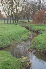
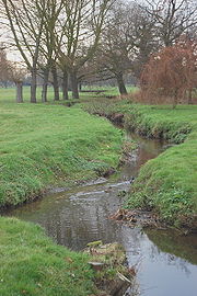
The River Roach is a river that flows entirely through the English
county of Essex
. It flows through the town of Rochford
and joins the River Crouch
at Wallasea Island
.
 Rochford takes its name from Rochefort, Old English for Ford of the Hunting Dogs. The River Roach was originally called the Walfleet (Creek of the foreigners). It was renamed the Roach in what is known as a back formation. This is where it is assumed that Rochford means ford over the River Roach so they renamed the river to fit the theory.
It has its source near Bull Wood in Hockley
. It runs south-west and passes south of the Grove Playing Field in Rayleigh and the Rayleigh Sewage Works, where it's flow is augmented by the discharge from the reed-bed purification system. From here through the Cherry Orchard Jubilee Country Park, under the B1013 and on into Rochford via the Golf Course before discharging into the northern arm of the estuary of the River Roach some 1.5 km upstream of the Horse and Groom public house. The River Roach joins the River Crouch at Wallasea Ness, The combined estuaries then discharge into the North Sea at Holiwell Point
 Light aircraft based at Southend Airport use the Roach as a navigation aid to guide them back to the runway
.
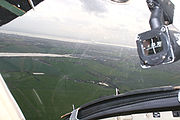
When flying visually the visibility is not always good enough to see long distances, so pilots use geographic features to confirm their position with what is shown on their charts. The Roach flows past Purdeys Industrial Estate, Rochford, which is very close to the threshold of Runway 24. Pilots returning from a flight north east of the airport would use the Roach to help align themselves with the runway.
The Roach can be seen in the centre left of the photo. The runway can just be seen to the left of the Compass
. The photo was taken 2.25 miles (3.6 km) or 1.96 nautical miles (3.6 km) from the runway threshold.
England
England is a country that is part of the United Kingdom. It shares land borders with Scotland to the north and Wales to the west; the Irish Sea is to the north west, the Celtic Sea to the south west, with the North Sea to the east and the English Channel to the south separating it from continental...
county of Essex
Essex
Essex is a ceremonial and non-metropolitan county in the East region of England, and one of the home counties. It is located to the northeast of Greater London. It borders with Cambridgeshire and Suffolk to the north, Hertfordshire to the west, Kent to the South and London to the south west...
. It flows through the town of Rochford
Rochford
Rochford is a small town in the Rochford district of Essex in the East of England. It is sited about 43 miles from Central London and approximately 21 miles from the Essex county town, Chelmsford...
and joins the River Crouch
River Crouch
The River Crouch is a river that flows entirely through the English county of Essex.The distance of the Navigation between Holliwell Point which is north of Foulness Island and Battlesbridge is 17.5 Miles, i.e. 15.21 Nautical Miles.-Route:...
at Wallasea Island
Wallasea Island
Wallasea Island lies in Essex, England. It is bounded to the north by the River Crouch, to the south east by the River Roach, and to the west by Paglesham Pool and the narrow Paglesham Creek....
.

It has its source near Bull Wood in Hockley
Hockley
Hockley is a large village and civil parish in Essex, England located between Chelmsford and Southend-on-Sea. More specifically it lies between Rayleigh and Rochford. It came to prominence during the coming of the railway in the 1890s and at the 2001 census had a population of 13,616 people, many...
. It runs south-west and passes south of the Grove Playing Field in Rayleigh and the Rayleigh Sewage Works, where it's flow is augmented by the discharge from the reed-bed purification system. From here through the Cherry Orchard Jubilee Country Park, under the B1013 and on into Rochford via the Golf Course before discharging into the northern arm of the estuary of the River Roach some 1.5 km upstream of the Horse and Groom public house. The River Roach joins the River Crouch at Wallasea Ness, The combined estuaries then discharge into the North Sea at Holiwell Point
Navigation aid

Runway
According to ICAO a runway is a "defined rectangular area on a land aerodrome prepared for the landing and take-off of aircraft." Runways may be a man-made surface or a natural surface .- Orientation and dimensions :Runways are named by a number between 01 and 36, which is generally one tenth...
.
When flying visually the visibility is not always good enough to see long distances, so pilots use geographic features to confirm their position with what is shown on their charts. The Roach flows past Purdeys Industrial Estate, Rochford, which is very close to the threshold of Runway 24. Pilots returning from a flight north east of the airport would use the Roach to help align themselves with the runway.
The Roach can be seen in the centre left of the photo. The runway can just be seen to the left of the Compass
Compass
A compass is a navigational instrument that shows directions in a frame of reference that is stationary relative to the surface of the earth. The frame of reference defines the four cardinal directions – north, south, east, and west. Intermediate directions are also defined...
. The photo was taken 2.25 miles (3.6 km) or 1.96 nautical miles (3.6 km) from the runway threshold.

